Produce and Present a Weather Forecast
Have you ever wanted to present the weather? Thanks to this Google Maps app now you can.
Using the application you can drag and drop weather symbols onto a Google Map to create your very own weather map. When your map is completed you can then watch a fly-through of your weather map. During the fly-through you can stand in front of your computer monitor and pretend that you are a real-life TV weather presenter. For added BBC realism you can even give the world the finger.
Currently you can place the weather symbols anywhere in the world but the presentation fly-through only works for the UK. The map developer says however thay he has plans to automate the generation of the fly-through route based on the symbol positions, which will mean that it will work for wherever you place the symbols. There are also plans to add more weather symbols for temperatures and for the wind.
Thursday, August 19, 2010


Data Animations with Google Maps
Timemap
Timemap is a Javascript library to help create Google Maps with the SIMILE timeline. The Timemap page on Project Hosting on Google Code has a number of really good examples of how to implement the SIMILE Timeline with Google Maps. A couple of the examples, in particular, are very impressive. One creates a Temporal Heatmap from a Google Spreadsheet and the other has some great Polygon Tweening.
Temporal Heatmap from a Google Spreadsheet

In this example the map markers increase in size to show the cumulative deaths from asbestosis and silicosis in Texas over time. As you move the timeline forward the circular map markers grow to reflect the cumulative number of deaths.
This is a great way to show any cumulative increase in data on a map. I'd really like to see an example that shows the growth in population by country over a number of centuries.
Polygon Tweening

This example uses a custom filter to smoothly tween a polygon between a beginning set of vertices and an ending set. The example doesn't seem to be a demonstration of any particular dataset but I can think of some great ways that this could be used.
This could be used to great effect to show the growth of an urban area over time. I'd love to see this used to illustrate the urban sprawl of London as it has crept out over the centuries to swallow up the surrounding countryside.
Timemap is a Javascript library to help create Google Maps with the SIMILE timeline. The Timemap page on Project Hosting on Google Code has a number of really good examples of how to implement the SIMILE Timeline with Google Maps. A couple of the examples, in particular, are very impressive. One creates a Temporal Heatmap from a Google Spreadsheet and the other has some great Polygon Tweening.
Temporal Heatmap from a Google Spreadsheet
In this example the map markers increase in size to show the cumulative deaths from asbestosis and silicosis in Texas over time. As you move the timeline forward the circular map markers grow to reflect the cumulative number of deaths.
This is a great way to show any cumulative increase in data on a map. I'd really like to see an example that shows the growth in population by country over a number of centuries.
Polygon Tweening
This example uses a custom filter to smoothly tween a polygon between a beginning set of vertices and an ending set. The example doesn't seem to be a demonstration of any particular dataset but I can think of some great ways that this could be used.
This could be used to great effect to show the growth of an urban area over time. I'd love to see this used to illustrate the urban sprawl of London as it has crept out over the centuries to swallow up the surrounding countryside.
Andy Dell is putting Hounslow on the map
Andy Dell is building some great 3D models of his local area, to the point where the Hounslow Chronicle did a story about him and his work (which I discovered via the 3D Warehouse Twitter account).

As you can see from the image above, he does excellent work with great attention to detail. The image above (of the Duke of York Pub), notice the roof overhang, expanded bay windows, tables, the Pub sign, the fence in back, etc. It's very well done.
So far 21 of his models have been accepted into Google Earth, which you can view in theGoogle 3D Warehouse.
The rest of Hounslow is still pretty bare in Google Earth, but with people like Andy on the job it'll be coming to life a little more every day.
The World's Happiest Countries Are ...
Yesterday I posted about Survey Mapper's happiness survey, which seems to suggest that Brazil is the happiest country. Here are some more maps exploring the 'happiness' ratings of the world's countries:
World's Happiest Countries

According to Forbes the Danes are the happiest people in the world.
Mibazaar has created this Google Map to display the results of the Forbes Happiest Countries list. The list is based on results from a Gallup World Poll that surveyed thousands of respondents in 155 countries, between 2005 and 2009.
The poll asked respondents to reflect on their overall satisfaction with their lives and asked questions about how each subject had felt the previous day. Mibazaar's map of the results uses numbered map markers so that you can tell at a glance where a country ranks on the list. The countries are also listed in the map sidebar in descending order.
Tweet Sentiments

TweetSentiments.com provides a snapshot view of the world's mood via a heat map from an analysis of Tweets. The site uses Natural Language Processing and Machine Learning technologies to analyse Tweets from around the world and then presents the results on a Google Map.
Happiness Map

Denmark also seems to be one of the happiest countries on Adrian White'sHappiness Map (pdf).
World's Happiest Countries
According to Forbes the Danes are the happiest people in the world.
Mibazaar has created this Google Map to display the results of the Forbes Happiest Countries list. The list is based on results from a Gallup World Poll that surveyed thousands of respondents in 155 countries, between 2005 and 2009.
The poll asked respondents to reflect on their overall satisfaction with their lives and asked questions about how each subject had felt the previous day. Mibazaar's map of the results uses numbered map markers so that you can tell at a glance where a country ranks on the list. The countries are also listed in the map sidebar in descending order.
Tweet Sentiments
TweetSentiments.com provides a snapshot view of the world's mood via a heat map from an analysis of Tweets. The site uses Natural Language Processing and Machine Learning technologies to analyse Tweets from around the world and then presents the results on a Google Map.
Happiness Map
Denmark also seems to be one of the happiest countries on Adrian White'sHappiness Map (pdf).
Facebook Places
 Facebook Places was launched tonight.
Interestingly the screenshots used in the launch and on the Facebook Blog all seem to use Google Maps. However the Bing Community blog says that it is using Bing Maps and seems to have the screenshots to prove it. My guess is that Facebook Places is using Google Maps for its iPhone app and Bing Maps on the Facebook website.
Unfortunately, for the rest of the world, Facebook Places at the moment is only available in the United States.
Facebook Places will allow you to check-in to locations, find friends who are nearby, track location history and find places and venues nearby. If a friend checks in nearby to your current location you will get a notification. Facebook Places will also allow you to tag photos and friends. Tagging friends essentially means that you can check-in your friends when they are at a location with you.
Facebook Places also looks like it will have place or venue pages. Each place will have its own page on Facebook. These place pages will show you who else is checked in right now at this location.
Facebook are launching an API for Places. The Read API is launching tomorrow. The Read API will let you access your check-ins and your friends' check-ins. There will also be a Write and Search API. This is currently in closed Beta.
Places comes with a number of privacy controls. By default your check-ins can only be viewed by your friends on Facebook. However it is possible to change your privacy settings to allow anyone to view your location data. Users will also be notified when they are tagged by a friend. You can then remove the tag if you want. You can also change your settings so that your friends can't tag your location.
Facebook today also announced a number of partners who will be utilising Places. These include Gowalla, foursquare, Yelp and Booyah.
If you have an iPhone you can use Facebook Places with the most recent version of the Facebook application for iPhone. You also can access Places fromtouch.facebook.com if your mobile browser supports HTML 5 and geolocation.
Open Street Map Routing, Directions & Export
OpenStreetMap (OSM) gets even more powerful with directions and routing tools.
Find, View and Export your custom directions.
Designed Routes for:

Simply have a start and end location - midpoints/waypoints can be included.

Directions 'explain' your routes, like a satnav would, turn by turn, includes all road names.

Export, a very useful component lets you export in GPS exchange format (.gpx) or waypoints (.wpt) format.
The map with route (above) example:
http://nroets.dev.openstreetmap.org/demo/index.html?lat=54.6&lon=-3.8&zoom=5&layers=B000TTTTT&v=motorcar&adj=recommended&markers=!50.06626%2C-5.71482!58.64026%2C-3.06984
Find, View and Export your custom directions.
Designed Routes for:
- Car
- Heavy Goods Vehicles
- Goods Vehicles
- Public Service Vehicles (Buses)
- Motorcycles
- Bicycles
- Pedestrian
- Moped

Simply have a start and end location - midpoints/waypoints can be included.

Directions 'explain' your routes, like a satnav would, turn by turn, includes all road names.

Export, a very useful component lets you export in GPS exchange format (.gpx) or waypoints (.wpt) format.
The map with route (above) example:
http://nroets.dev.openstreetmap.org/demo/index.html?lat=54.6&lon=-3.8&zoom=5&layers=B000TTTTT&v=motorcar&adj=recommended&markers=!50.06626%2C-5.71482!58.64026%2C-3.06984
The Iterative Web App: New Stacked Cards Interface for Gmail on iPad.
In April 2009, we announced a new version of Gmail for mobile for iOS and Android. Among the improvements was a complete redesign of the web application's underlying code, which allows us to more rapidly develop and release new features that users have been asking for, as explained in our first post. Today’s topic for the The Iterative Web App, a series where we continue to release features for Gmail for mobile, is the Stacked Cards Interface on the iPad.
When we announced our new interface for Gmail on the iPad, we requested feedback on how we could improve this experience for tablet devices. In June, we responded with a new compose screen. Today, we’re addressing the top feedback by launching a new “stacked card” interface for selecting and managing multiple conversations.

In the past, performing actions on selected conversations was awkward. There were two similar toolbars on the screen: one on the bottom left and the other on the top right. The former affected the selected conversations, while the latter affected the currently open conversation. Since the toolbars’ buttons looked similar, it was easy to mistakenly use the wrong toolbar. Sound confusing? It was.
In the new interface, selected conversations are displayed stacked on the right panel for easy organizing, archiving or deleting. The second toolbar is gone so it’s always clear which conversations you’re working with.
This new interface has also been an opportunity for our team to experiment with CSS3 transitions, which give mobile web applications a similar look and feel to native applications. More details on the implementation are posted on the code blog.
To try the Gmail webapp on the iPad, just go to gmail.com in Safari. For quick access, create ahomescreen link. Please note that the new interface is only available in US English for now.
When we announced our new interface for Gmail on the iPad, we requested feedback on how we could improve this experience for tablet devices. In June, we responded with a new compose screen. Today, we’re addressing the top feedback by launching a new “stacked card” interface for selecting and managing multiple conversations.

In the past, performing actions on selected conversations was awkward. There were two similar toolbars on the screen: one on the bottom left and the other on the top right. The former affected the selected conversations, while the latter affected the currently open conversation. Since the toolbars’ buttons looked similar, it was easy to mistakenly use the wrong toolbar. Sound confusing? It was.
In the new interface, selected conversations are displayed stacked on the right panel for easy organizing, archiving or deleting. The second toolbar is gone so it’s always clear which conversations you’re working with.
This new interface has also been an opportunity for our team to experiment with CSS3 transitions, which give mobile web applications a similar look and feel to native applications. More details on the implementation are posted on the code blog.
To try the Gmail webapp on the iPad, just go to gmail.com in Safari. For quick access, create ahomescreen link. Please note that the new interface is only available in US English for now.
Wednesday, August 18, 2010
Get Local Tips on Google Maps
Geosay

Geosay is a local information Google Map for finding out what people are saying about different locations on foursquare, Twitter and Wikipedia.
To use the map just enter a location and you can see all the results directly on the Google Map. The results are also listed in the map sidebar, ordered by distance.
It is easy to create a marker for Geosay. Just add the hashtag #geosay to any geolocated tweet and it will be stored in the Geosay database and appear on the map. Geosay has a mobile version of the map. Just go to http://geosay.com in the browser of your mobile phone and you can find local tips wherever you happen to be.
Geosay is a local information Google Map for finding out what people are saying about different locations on foursquare, Twitter and Wikipedia.
To use the map just enter a location and you can see all the results directly on the Google Map. The results are also listed in the map sidebar, ordered by distance.
It is easy to create a marker for Geosay. Just add the hashtag #geosay to any geolocated tweet and it will be stored in the Geosay database and appear on the map. Geosay has a mobile version of the map. Just go to http://geosay.com in the browser of your mobile phone and you can find local tips wherever you happen to be.
A Big Thank You to our Growing Community of Bike Map Contributors
When we added U.S. biking directions to Google Maps back in March, we were eager to see the response from the cycling community. Through our partnership with the Rails-to-Trails Conservancy, we had detailed bike lane and trail information for 150 cities; and for the rest of the country, we recommended routes based on other data such as the size of the road, speed of traffic and hill steepness. On one hand, it would’ve been ideal for our directions feature to know about all the bike lanes and trails in the country. But on the other hand, we were aware that biking directions were one of our most-requested features and we wanted to provide information for bicycling fans as soon as possible.
So rather than wait, we decided to launch biking directions in “beta” and ask our community of bicycle-bound users for their help improving our bike maps. Through our “Report a problem” tool, any user can send us corrections or recommend improvements, and receive notifications from Google when their report has been resolved. We always knew the cycling community would be a passionate bunch, but the response to both our biking directions feature and our call to join in the effort to improve our bike maps has surpassed our happiest expectations.
More than 10,000 people have submitted about 25,000 suggestions for improvements to our bike maps. With their help, we’ve added bike lane and trail data for an additional 80 cities since our initial launch. This is an exciting and humbling response from the Google Maps community. It’s like having 10,000 new members of our bike maps team, contributing their time and energy to make Google Maps more useful for everyone.
These contributors have impacted biking directions across the nation - in small and large ways. Here are some examples of suggestions we’ve received:
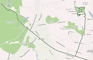

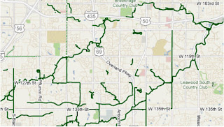
This is how we’ll build a great cycling map: Bit by bit, getting better with every tip and suggestion that users share about the lanes and trails they’ve ridden.
We want to say “Thank you!” to all those who’ve answered our call for bike map contributions. Clearly our users are passionate about helping to make our maps better, so we’re working hard to make the improvement process even easier and to speed up the processing time for user contributions.
In the meantime, happy biking! Just remember that our biking directions are still in beta, and to always use your judgement - don’t ride down any road that makes you uncomfortable. And if we’ve recommended a road that shouldn’t be used by the average bicyclist, let us know!
So rather than wait, we decided to launch biking directions in “beta” and ask our community of bicycle-bound users for their help improving our bike maps. Through our “Report a problem” tool, any user can send us corrections or recommend improvements, and receive notifications from Google when their report has been resolved. We always knew the cycling community would be a passionate bunch, but the response to both our biking directions feature and our call to join in the effort to improve our bike maps has surpassed our happiest expectations.
More than 10,000 people have submitted about 25,000 suggestions for improvements to our bike maps. With their help, we’ve added bike lane and trail data for an additional 80 cities since our initial launch. This is an exciting and humbling response from the Google Maps community. It’s like having 10,000 new members of our bike maps team, contributing their time and energy to make Google Maps more useful for everyone.
These contributors have impacted biking directions across the nation - in small and large ways. Here are some examples of suggestions we’ve received:
- One user simply pointed out to us, “Wall Township Bike path - http://www.wallrec.com/bicycling.htm.” Our response to that short and sweet message?Here it is:

- Some else sent a note saying, “CSUS - there has been a bike/foot traffic tunnel that connects elvas ave to College town dr for about 6 years. it is located between 64 & 65 st.” Well, that’s handy to know! Done:

- And yet another user shared, “Cycle/hiking path continues to the East across Switzer and connects with the path that is currently shown on google maps ~2.5 miles to the ENE at 130th and Metcalf Ave. Details on Overland Park website http://www.opkansas.org/Resource_/PageResource/Maps-And-Stats/Maps/Adobe-Acrobat-PDF-Maps/bike_route_plan.pdf Thanks.” Awesome! Overland Park is nowlooking pretty good for cyclists:

This is how we’ll build a great cycling map: Bit by bit, getting better with every tip and suggestion that users share about the lanes and trails they’ve ridden.
We want to say “Thank you!” to all those who’ve answered our call for bike map contributions. Clearly our users are passionate about helping to make our maps better, so we’re working hard to make the improvement process even easier and to speed up the processing time for user contributions.
In the meantime, happy biking! Just remember that our biking directions are still in beta, and to always use your judgement - don’t ride down any road that makes you uncomfortable. And if we’ve recommended a road that shouldn’t be used by the average bicyclist, let us know!
Google Maps - Your Personal Travel Guide
Nile Guide

Nile Guide is a great trip planner and personal travel guide. The site lets you explore areas you might like to visit for hotels, restaurants and other points of interest and create your own personalised travel itinerary.
To start planning your trip with Nile Guide you just need to enter your destination. Nile Guide will then give you an overview of your destination and allow you to view Hotels, Things to Do, Restaurants, Nightlife and Events. The points of interest are even displayed on a Google Map.
To add a place you want to visit you just need to click on the 'Add to List' link and it will be added to your 'My Guide'. Once you have added a number of destinations to your travel itinerary you can then organise your guide. You can drag and drop your different picks on to different days of your trip and you can view the locations of your choices on a Google Map.
When you have completed your personal travel guide if you press 'Print my guide to go' Nile Guide will create a printable version of your very own travel itinerary.
Nile Guide is a great trip planner and personal travel guide. The site lets you explore areas you might like to visit for hotels, restaurants and other points of interest and create your own personalised travel itinerary.
To start planning your trip with Nile Guide you just need to enter your destination. Nile Guide will then give you an overview of your destination and allow you to view Hotels, Things to Do, Restaurants, Nightlife and Events. The points of interest are even displayed on a Google Map.
To add a place you want to visit you just need to click on the 'Add to List' link and it will be added to your 'My Guide'. Once you have added a number of destinations to your travel itinerary you can then organise your guide. You can drag and drop your different picks on to different days of your trip and you can view the locations of your choices on a Google Map.
When you have completed your personal travel guide if you press 'Print my guide to go' Nile Guide will create a printable version of your very own travel itinerary.
Subscribe to:
Posts (Atom)