Friday, August 13, 2010

Tracking Bands with Google Maps

Music Enthusiast

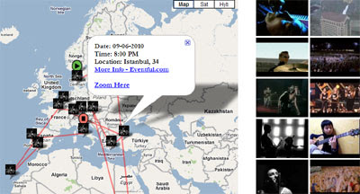
If you want to find where your favorite band or artist is playing you could do worse than search Music Enthusiast. Music Enthusiast searches Eventful for upcoming concerts and plots the results on a Google Map. 

To view the scheduled concerts of a band or artist you just need to enter their name. Music Enthusiast then searches Eventful and adds a map marker for each concert date it finds. It even plots the concerts in chronological order. The green marker shows the first concert on the tour and the red marker shows you the location of the tour's finale.

Music Enthusiast also searches YouTube for you. So once you have finished searching for concerts you can click on a YouTube thumbnail and watch a video of your favorite band.

Hat-tip: Mapperz

Google Earth Enterprise 4.0 now available

The Google Earth Enterprise team has long focused on bringing the innovative features of Google Earth and Maps to businesses, enabling them to create their own mapping applications from their existing data archives. Over the years we’ve released new features that have expanded the options for rapid, secure dissemination of geospatial data with Google Earth Enterprise (GEE), and with today’s release of GEE 4.0, we’re happy to announce support for two more important capabilities: mobile-based access to GEE systems, andGoogle Earth Enterprise Portable Solution. We’re also excited to let you know about the latest versions of the Google Earth Enterprise Client and Plug-in.

Mobile Access to your Globes

In February we released a native Google Earth client for Android
to the Android Market. With GEE 4.0, the Android Google Earth client has been updated to support direct connections to customers’ globes, which permits their end-users to view their organization’s 3D globe, including all imagery, terrain, and vector layers, with support for custom vector search.

Google Earth Enterprise Un-Plugged

Some of you might have heard during a recent Directions Media Webinar that many of our GEE customers need to provide their end users with access to geospatial data for situational awareness, even when those users are in environments with limited or no Internet connectivity. To support this, GEE 4.0 introduces a new feature that permits authenticated end users to extract portions of a published GEE globe -- including all imagery, terrain, vectors, KMLs, and search -- and serve the data locally from their own laptops or other storage devices using a native, cross-platform, light-weight Portable Earth System.

Check out this video to see how the portable capability works.


Google Earth Enterprise Client 5.2
GEE 4.0 also has full support for the new Google Earth 5.2 client, with its many great new features, such as elevation profiles, native MGRS support, client-side data regionation, and the new embedded web-browser.

Google Earth Plug-in Updates
In addition to performance improvements, the latest release of the Google Earth Plugin includes support for historical imagery databases and the ability to connect to multiple globes simultaneously.

Existing customers can find GEE 4.0 upgrade information by logging into the Google Enterprise Support Portal.

Imagery of the flooding in Pakistan

UPDATE, 13-August: Google has now put out a blog entry with a lot more info from their Crisis Response team about the flooding -- read it here.
A few days ago we told you that Google was seeking imagery and data for the flooding in Pakistan. While they're still working to acquire more data, NASA has released some imagery of the country and it's quite stunning.
pakistan-flooding.jpg
You can view/download the images on the NASA Earth Observatory site. You can also view it by downloading this KML overlay -- be warned that the image is approximately 9 MB, so it'll take a little while to load.
If you wish to offer your resources to help, Network for Good has a list of organizations that are accepting contributions, along with a description of what each organizations will do with your donation.

Mapping Happiness with Google Maps

Mappiness

Two academics at the London School of Economics are carrying out research into how the environment affects people's happiness. To help them gather the data for this research they have launched an iPhone app called mappiness. 

If you download the app you will receive a notification between one and five times a day. The notification will ask you to open the app, briefly report how you're feeling and who you're with, where you are, and what you're doing. If you're outdoors and you're happy to, you'll be asked to take a photo of your surroundings as well.

You can also open the app and report on your feelings and situation, unprompted, as often as you like.

Anyone can keep an eye on the research being gathered by checking out the mappiness Google Map. The map shows the outdoor places where mappiness users have most recently reported feeling happy. If you click on an information window you can also view the photograph taken at that happy moment.

If charts and graphs are more your thing you can also check out the happiness meters and a graph of happiness levels charted over the past few days.

Is that a body in Street View?

For those people concerned about privacy in Google Street View, this almost takes it to a new level. A story has been going around that Google accidentally captured images of the body of young girl in the street outside her home. Frankly, the images are quite convincing:
dead-girl-in-streetview.jpg
Fortunately, the girl is perfectly fine and was just playing around. Her name is Azura Beebeejaun, and she's simply amused by all of the attention! She said she was just playing with friends when the car went by.
azura-standing.jpg
It's possible that Google will remove the image, but in the meantime you can view it in Google Maps here or in Google Earth with this KML file.
What's the strangest thing you've seen in Street View?

Friday Fun with Google Maps

Song Lyrics as Google Maps Directions

BuzzFeed have been having fun this week turning song lyrics into Google Maps directions. Their readers have joined in the fun and there are even more suggestions in the comments.

Fata Morgana

I rather like this Google Map that has used the Map Styles function to create a Google Map that only includes the name labels. It is surprising how may locations are still clearly recognisable just from the shapes created by the names. 

Bing Maps - CachEye


CACH'EYE is a free personalised geocaching map service based on a Bing Maps application. Each user can define the content of his personal cachemap. Cache data are imported from Pocket Queries, from GPX- / LOC-Files or are exported from Geocaching Swiss Army Knife (GSAK) and visualised in an easy-to-use interactive map.

CachEye BING Maps OSM Layer
Clear, creative mapping for geocaches around the world.

Version 1.1 has many new features

  • Caches and additional waypoints now can be imported into the map directly from your Pocket Queries using the PQ-ZIP-File or still by using a GSAK-macro (as in V1.0), Up to 3000 caches plus waypoints may be displayed.
  • A single cache may be imported and visualized on the map via a GPX- or LOC-File.
  • Caches and additional waypoints now are associated to each other. With Focus/cache the map highlights and zooms to all waypoints of a specific cache.
  • ToDo-Lists assist you in quick and easy route planning. Todo-lists are named and you can maintain several lists.
  • Now you may move solved "Mysteries", "Multicaches" and "Other Caches" to corrected coordinates on the map in case you did not import this cache from GSAK.
  • Openstreetmap also can be used as the basemap.
  • Measure distance tool
  • Altitude display (approx.) in Cache/Waypoint/Marker Popup
  • Metrics (km/miles) may be changed in account settings / information.
  • Displays waymarks on the map for GSAK-based datasets
  • Invoke the "Log Your Visit" page directly from within the map
  • Better appearance on 800x600 screen resolution
Map Demo:
http://demo.cacheye.org/

More information on CachEye
http://www.cacheye.org/panel/front