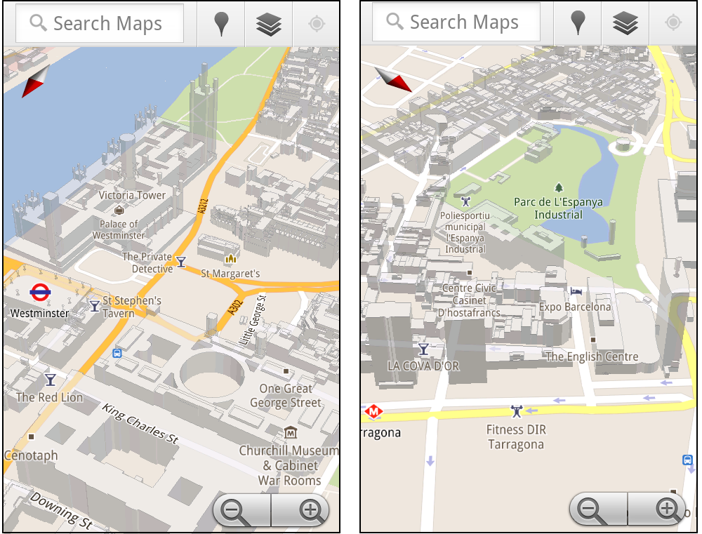
Google have today added 3D buildings to Google Maps in more cities around the world. The new cities include London, Paris, Barcelona, Stockholm, Singapore, Lisbon, Boulder, and 11 major cities in South Africa.
In Google Maps the 3D buildings look pretty cool but they really only come to life on Google Maps for mobile. On Google Maps for mobile you can rotate, tilt, and zoom in and out on the buildings.

My guess is that at some point soon Google will look to implement the rotate and tilt views in Google Maps for the desktop.
The rotating buildings obviously make more sense on mobile maps where the orientation of the map can rotate to reflect your view. However this would be a great feature to be able to access via the Google Maps API. I could see this being a popular tool with many map developers.
Via: Google LatLong

Like many big cities Boston has very fluid neighborhood boundaries. Two people living next door to each other can often have very different ideas of which district they live in.
To try and clear up some of the confusion around Boston's boundaries Boston.com has created a Google Map that shows the different boundaries used by the Boston Redevelopment Authority, by the police, by the city and those determined by zip code.
Using the map you can drag the map pin around to view the different district boundaries at different locations.
Exploring Boston's Tangled Boundaries
Cooler Planet: Solar Energy Installation Map

Cooler Planet has created an animated time-line with Google Maps to show the progress of solar installations in California from 1999 through to 2011.
Using data from Go Solar California Statistics the map lets you view time-lines of 'total installs', 'total watts', 'watts per install' and 'total carbon saved'. It is fascinating using the map to view how solar power installations have blossomed in California over the last decade.
Google Maps now lets you search with 'descriptive terms'. Google describes 'descriptive terms as "the phrases which are most frequently used to describe ... places".
So, for example, if I want to find a pub that has quiz nights I can just type in 'quiz night' into the search bar on Google Maps. I will then be shown all the places that have 'quiz night' mentioned in reviews and other information gathered about the venue.

Other descriptive terms that I can imagine myself using a lot are 'great coffee', 'free wifi', 'free delivery' and 'live music'.
I'm sure I'll be using this new feature a lot!
Walking the Edit

Walking the Edit is an innovative iPhone app that allows you to create a mapped video. It is a great way to create a guided video walk or a video about your neighborhood.
Using the app you can take a walk through a neighborhood and the iPhone app tracks your progress and stores the location of the videos that you take on your journey. When you have finished your walk the app then creates a Google Map of your route with your synchronised video.
The videos are displayed on your automatically created map by small map markers. The size of the marker represents the duration of the video at that location. When you play the video the map view synchronises to the location of the video.
Sk8loc8

Sk8loc8 provides a searchable Google Map of over 1800 skateparks and skateshops around the world.
You can search the map by location and view nearby Skateparks, Recommended Parks, Skate Shops and Unconfirmed Skateparks. You can also click on the map to load nearby skating locations or to add the location of a missing skatepark.
Longboarding and Skateboarding Map

Here is a great map to help skateboarders find the best places to skate in their neighborhood. Edmonton longboard and skateboard shop Local 124 has created this worldwide Longboarding and Skateboarding Map of crowdsourced skating routes.
Anyone can add a route to this Google Map of skating spots and the map can be searched by location and by category. If you click on a map marker you can read details about the spot, rate it and leave comments.
A map sidebar lists the latest routes added to the map and it is also possible to view the locations of upcoming sessions and races on the map.
Toronto is Trending

Toronto is Trending has one of the coolest welcome screens I've ever seen on a website. When you go to Toronto is Trending you are presented with a full-screen video of Toronto. Twitter speech bubbles then appear above some of the moving pedestrians in the video and follow them down the street.
If you switch to the 'map view' you can then see the latest Tweets and check-ins made in Toronto on a Google Map view of the city. The map also displays a number of hotel, ticket and package deals.
The numbered map markers let you see how many people have checked into particular venues. You can select which category of venue you wish to see displayed on the map using the icons at the top of the map.
Altogether if you want to find the most happening venues in Toronto right now then you need to visit Toronto is Trending.
Toronto’s Most Dangerous Intersections

Global Toronto has mapped out Toronto's most dangerous intersections for pedestrians. By looking at the accident history data for 1337 intersections in the city Global Toronto has been able to identify which pose the most danger to pedestrians.
Global Toronto devised an 'accident ratio' for each intersection by combining two sets of data: accidents by intersection from 2000-09 and the average daily pedestrian head-counts at each intersection.
The Google Map shows in red the intersections that have the highest accident ratio.
Bangkok Traffic

Bangkok Traffic is a driving directions application for the Thai capital that also displays real-time traffic information.
To get driving directions you can drop two map markers on a Google Map or enter your starting point and destination into the search box. Your route is then displayed on the map and listed in the map sidebar.
Also displayed on the map is real-time traffic information, showing current traffic speeds on the city's roads. It is also possible to click on the webcam map markers to view real-time images from the city's traffic cams.
Prey
Prey is a great way to recover your laptop or phone if it is stolen. If your laptop is stolen and you have have signed up to Prey you can track your computer with the help of Google Maps.
Prey uses either your device's GPS or the nearest WiFi hotspots to triangulate and grab a fix on its location. It can then show you the location of your stolen property on a Google Map. All you have to do then is report the thief's address to the police and await the return of your computer.
Prey also comes with some other handy features, such as being able to take a photo of the thief with your laptop's webcam or being able to take a screenshot remotely (perhaps catching the thief's name whilst they are on online).
Storify has a really interesting account of how someone managed to recover their stolen laptop with the help of Prey and some Twitter friends.
Flow

Water for People is a charity helping people in developing countries through the development of locally sustainable drinking water resources, sanitation facilities, and hygiene education programs.
Water for People are using remote technology to display real-time reports about whether their water and sanitation projects are working or failing. The map allows field workers, volunteers and others to record data from tens of thousands of water points around the world.
Flow uses categorised markers to show which projects are currently functioning, broken or functioning with problems. The links in the map side-panel allow users to quickly zoom to Water for People's different projects around the world.
Asian Carp Map

Reporter Tina Lam and photographer Brian Kaufman have embarked on a 13 day journey through seven states to track how far the invasive species of the Asian Carp are getting to the Great Lakes.
A Google Map is being updated regularly with photographs and reports of their findings. The map includes a time-line so that you can follow the pair's progress chronologically as well as geographically.
If you click on any of the mapped photographs an information window opens so that you can read the submitted report. You can also click through to read the story on the Detroit Free Press.
Canada & UK Post-Elections Round-up

Patrick Cain this week has spotted some post-election Google Maps from theVancouver Sun and The Guardian.
In Canada the Vancouver Post's map looks at the loss of seats by the federal Liberal party in British Columbia, whilst The Guardian maps the results of the British referendum on the Alternative Voting system.
The Guardian's map shows how there was very little support for the Alternative Voting system outside of a few London boroughs, the university towns of Oxford and Cambridge and central Glasgow and Edinburgh.
The Google Places API is now on general release and a Places Library has been added to the Google Maps API.
The new Places Library allows map developers to display venues in Google Places on a Google Map. The venues can be added either via a bounding box or within a radius of a centre point. The displayed venues can be refined by type (e.g. gym, food, zoo, art gallery etc) or by name (e.g. Starbucks).

The Places Library can also display details about the returned venues, including full address information and user ratings.
The Places Library for the Google Maps API doesn't seem to support check-ins. So if you want to give your users the ability to check-in at venues it looks like you will have to use the Google Places API itself with your Google Maps.
Via: Google Geo Developers Blog
Groupon Now

Groupon has finally turned on location and has become a lot more useful in the process. Groupon Now lets you view the nearest deals to your location on a Google Map. It is available both from your desktop and from your mobile device.
Actually Groupon Now is a bit of a misnomer. It should more accurately be called Groupon Later because, for now, it is only available in Chicago. If you are lucky enough to live in the Windy City then you can enter your address and search for deals by category.
The results of your search are displayed on a Google Map and each deal comes with a timer informing you just how long you have left to redeem your deal. The application works really well and, once a few more cities are added, should help to cement Groupon's position as the leading deal-of-the-day provider.
PigeonMap

Pigeon Map is a free classifieds website that uses Google Maps to let you find classified ads near your location.
The classified ads come in many categories with advanced search options. You can search by location and by category, including 'deals', 'events', 'jobs' and 'for sale'. Results of a search are then displayed on the map.
Users can also post their own classified ads to the map by completing a short form.
Radiactivdad

Since the recent disaster at the Fukishima Nuclear Power Plant we have seen a number of Google Maps that show the location of nuclear power plants around the world.
For example Zeit-Online created the American Nuclear Power Plants Map to show how many Americans live near nuclear power plants. Another trend has been to create Google Maps that display radiation measurements.
Radiactivdad is a Google Map that displays the locations of Spain's nuclear power plants and also the results of radiation monitors in the country that have been connected to the web using Pachube.
Contando Estrelas: Chernobyl 25 Years Later

Today marks the 25th anniversary of the accident at the Chernobyl Nuclear Power Plant in the Ukraine. Google Maps' satellite view gives us a great insight into the devastation of this once thriving area.
Italian website Contando Estrelas has written an informative article on the destruction of the area around the nuclear power plant in Chernobyl, which it has illustrated with satellite views from Google Maps.
The article shows images of the power plant itself, the now ghost town of Pripyat (including a Ferris wheel that had been constructed for the May 1st celebrations), abandoned ships in a port to the north of Chernobyl and a graveyard of trucks, tanks, helicopters and other vehicles used after the explosion of 1986 (all of which had to be abandoned because of their exposure to high radiation levels).
The article is in Spanish.
Generate a Panorama

'Generate a Panorama' lets you click on a Google Map and see a representation of the view from that location.
For example, below is the generated view from the summit of Mont Blanc looking due west. As you can see all the peaks in your view are marked on the created panorama.

To generate your own view you just need to click on the map. You can drag a polyline to choose the direction you wish to view and you can also adjust the span of the view.
Also See
Hey What's That - The original and first Google Maps based panorama generator.
Mere Sverige

Mere Sverige (More Sweden) is a tourism promotion site for Sweden aimed at the Danish market. The site is therefore in Danish. More Sweden uses Google Maps to provide Danish visitors to Sweden with all the accommodation and sightseeing information that they will need.
The map includes some very nice features. In particular the numbered marker clustering solution is well thought out. Numbered markers show the number of points of information at a location. If you mouse-over the marker a small information window opens with preview thumbnails of the individual locations. If you click on the marker the map zooms in so that you can view the individual markers.
Markers on the map are divided into the categories of 'experiences, 'accommodation' and 'transport' and each of these categories is further subdivided. For example 'accommodation' contains sub-categories of hotels, B&B's etc.
Checkin Mania: Check-in Deals

Check-in Deals lets you find all the local businesses offering deals through Foursquare. All you have to do is type in your location and you can view all your nearby deals on a Google Map.
As well as being displayed on the map all the deals are listed in the map sidebar. You can filter the displayed deals by 'Newbie Special', 'Check-in Special', 'Mayor Special' etc. If you click on the sidebar listing the location of the selected venue is displayed on the map
The Royal Zombie Wedding

There is a Royal Wedding taking place this Friday in London.
As you can imagine the burning question on everyone's lips is:
Can the wedding survive a zombie attack?
Thanks to the makers of Class 3 Outbreak, the Google Maps zombie game, we can now simulate the effects of a zombie attack on Westminster Abbey during the royal wedding and discover the answer to this important question.
After extensive testing of the simulator I can attest that things don't bode well for William and Kate. By my reckoning the happy couple will enjoy about five minutes of married life before joining the leagues of the walking dead.
On a more happy note a zombie attack won't make much difference to the royal family. It has been rumoured that the Queen's husband Prince Philip has been zombified for the last twenty years with very little noticeable effect on his ability to perform his royal duties.
As a reward for their work on the The Royal Zombie Wedding game creatorsBinary Space have been awarded a permanent room in the Tower of London by the UK government.
Royal Wedding Tweets Map

Judging by the number of Tweets with the hashtag #royalwedding I'm guessing that some kind of wedding is coming up. Mibazaar has also picked up on this strange trend and has created a Google Map to show all the latest royal wedding chatter on Twitter.
The map displays the latest tweets with the #royalwedding hashtag that have been posted from in and around London. The map animates to show the latest Tweets, so it is possible to just sit back and read how people are reacting to this wedding.
The map is already showing a huge amount of activity. I hope it can cope with the amount of Twitter messages that will be flying around on Friday 21st.
MyPetrolPlace.com

This new Google Maps based application allows you to work out the cost for your car or motorbike journey in India based on the current cost of petrol in your city.
To use MyPetrolPlace.com enter a starting point and a destination. Then add the number of kilometres per kilogram your vehicle normally achieves. The application then calculates your daily and monthly fuel expenditure.
Your journey is also displayed on a Google Map. You can change the displayed route by dragging the markers. All the metro cities and state capitals in India are supported by the application.
Psyked: Experiments with HTML5 Geolocation

Your real name is Jason Bourne and at this very moment CIA spy satellites are honing in on your location in an attempt to track you down ...
James Ford has been experimenting with geolocation in HTML5. The result is this rather scary Google Map with an unmanned aerial vehicle type of interface.
The map detects your location (in my case with amazing precision) and then proceeds to load a lot of information about your location. For my UK address the information included the road I live in and my postcode.
I really think it is time that we found out a little more about these Treadstone guys ...
Zeit-Online: American Nuclear Power Plants Map

German newspaper Zeit-Online has created a Google Maps application that shows how many Americans live near nuclear power plants.
The map includes a distance slider tool that lets you visualise how many people live within different distances of a nuclear power plant. For example, the voluntary evacuation zone around the Fukushima power plant is currently 18 miles. Using the Zeit-Online map we find that a total of 16,040,474 Americans live within 18 miles of a nuclear plant.
You can use the slider to adjust the radius around the nuclear power plants. The number of people living within the radius is then shown. Clicking on a power plant on the map brings up more information about the location in the map sidebar.
Google have added new 45° imagery on Google Maps for Rome.

New bird's eye views have also been added in:
St Louis, MO
Honolulu, HI
New Orleans, LA
Rome, Italy
North Austin, TX
West Norfolk, VA
Scottsdale, AZ
San Rafael, CA
Palm Springs, CA
Lake Forest, CA
Boulder City, NV
Aerial View Map

I've updated my Aerial View map to include some of the amazing sights around Rome captured in Google's new 45° imagery. The map also includes some pretty stunning imagery from Venice, the USA and South Africa.
Google Maps Colorizr

The Styled Maps feature, released in the Google Maps API last year, has proved really popular. It allows map designers to alter the look of Google Maps to match the design of their websites or to emphasise particular map features.
Google's Styled Map Wizard is a great tool for experimenting with and perfecting a style for your Google Map. However the Styled Map function and the Map Wizard both use HSL colors rather than HEX RGB colors, which may be confusing to some users.
The advertising agency stadt.werk has created a new wizard that lets you design your map style in the more familiar HEX RGB colors. The Google Map Colorizr conveniently transfers your HEX RGB colors to the HSL colors used by Google Maps and allows you to cut and paste the code of your finished map style.
The Google Map Colorizr even has a dynamic URL. So if you want to ask someone's opinion about a particluar map style you can send them a link.