Friday, January 28, 2011

Friday Fun with Google Maps

Street View Art

Photographer Michael Wolf is currently exhibiting at the Peurs sur la Ville exhibition at the Monnaie de Paris. His exhibition consists of a series of images collected from Google Street View.

Google API Periodic Table

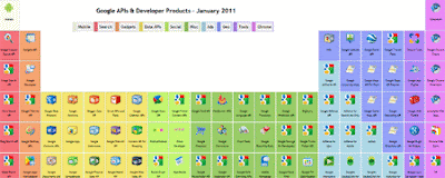
I love this periodic table of all the Google API's. Not only does it look neat, it is pretty useful as well. Geo developers will be mostly interested in the blue API's, which are all geo related.

More Fun With Google Reviews


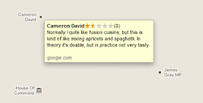
Google Maps in the UK is displaying a restaurant at the Houses of Parliament called the 'Cameron David' (David Cameron is the British Prime Minister). If you click on the icon there are a number of reviews. For example this handy guide on how to find the (non-existent) restaurant,

"Difficult to find. For those struggling to find David Cameron, walk towards Thatcher then take a sharp right."

Street View Hunting

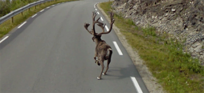
Google Sightseeing have been Street View hunting and managed to bag this impressive looking reindeer in Norway.

______________

Labels:

Google Map of Egyptian Protests

Aljazeera: Mapping Egypt's Day of Wrath

Aljeezeera are using Google Maps to provide up-to-date information about the geographic spread of today's protests in Egypt.

The website of Aljeezeera is displaying two maps, one that shows the location of protest locations in Cairo and the other showing the protests being held elsewhere in the country.

The maps are also accompanied by the video above which also uses Google Maps satellite imagery to provide some context about the locations of the protests.

______________

The Wrath of Grapes on Google Maps

Where it Went Down


Ever had one of those mornings when you have woken-up hungover and a niggling feeling that you probably did something really stupid the night before? At some point during the day the memories start to come back and you begin to wish the earth would open you up and swallow you whole.

Really your only hope is that the rest of the world has suffered collective amnesia and that the whole episode will pass by unnoticed or at least unremarked.

Well MTV believe that rather than be embarrassed about your drunken exploits you should celebrate them and share them with the world on their 'Where it Went Down' Google Map.

To help promote the television season of Skins, MTV want you to "share the places where memories were made - and the scattered pieces of nights you can’t really remember."

And remember kids prospective employers are always really impressed when they Google your name and discover that you are capable of downing "16 bottles of vintage champagne" and then taking part in "a threesome, a foursome and ludicrous amounts of E."

Thursday, January 27, 2011

Foreclosure for Google Maps Real Estate


Google Maps users in the US, UK, Australia, New Zealand and Japan until now have been able to search for real estate directly on Google Maps. However Google today announced that they are removing real estate results from Google Maps.

The search giant gives two main reasons behind the removal, low usage and the impending retirement of the Google Base API. Real estate will be discontinued on Google Maps on February 10, 2011.

Via: Google LatLong: Retiring real estate on Google Maps

Wednesday, January 26, 2011

A Customised Campaign with Google Maps

Give a Minute

Give a Minute has used the Google Maps API to create a very interesting campaign. The Give a Minute campaign is encouraging people to post ideas about how they can improve their cities.

The site contains four customised Google Maps, one each for Chicago, Memphis, New York and San Jose. Each map replaces the Google Map tiles with a custom image of the city. The latest ideas submitted to the site are then overlaid on the image in the form of post-it notes.


Using the usual Google Maps navigation controls you can zoom in and read any of the submitted ideas. You can also order the ideas by 'most recent' and 'most shared'.

______________

Labels:

View Snow Depths on Google Maps

Snowdepth Map

This Google Map shows the snow depths at European ski resorts.

The map uses colored map markers to show at a glance the depth of the snow at different resorts. If you click on a resort's map marker you can click through to view a full snow report for the selected resort.

The same site also provides a Google Map of the current weather conditions. This map includes options to view today's and tomorrow's weather conditions at European ski resorts.

______________

Labels:

Help a Toad Across a Road?

Frog Life

Frog Life has used the Google Spreadsheets Map Gadget to create a Google Map of toad migration routes in the UK. The map is designed to highlight locations where toads could encounter problems crossing roads during the spring breeding season.

The map shows places where toads are known to cross roads. It provides information on whether road signs or volunteer crossing schemes are in place at each location and provides contact information for those who wish to volunteer to help toads cross roads during the breeding season.

Via: BBC

______________

Labels: ,

Tuesday, January 25, 2011

The World's Newspapers on Google Maps

Newspapermap

This Google Map provides a great way to browse nearly 10,000 of the world's newspapers.

The newspapers are categorised on the map by language. Each information window contains links to the websites of the listed newspapers and to read the papers through Google Translate.

If you visit the site on your mobile you can view a special Google Map customised for phones. The mobile site has been built with the jQuery Mobile framework so will work on most mobile phones.

Google Boost: Now Appearing On Mobile Phones

Back in October we announced Google Boost, a new advertising solution to help local businesses connect with potential customers in their area. Today we are excited to announce that Boost ads can appear on Google Search results pages on Android and iPhone devices.


Consumers increasingly use mobile devices to search for products and services, and Boost will give advertisers the opportunity to reach these customers exactly when they are looking for local businesses on their phones. This feature will automatically take effect for current and future Boost advertisers.

In case you aren’t familiar with Boost, it’s Google's new advertising product that helps business owners quickly create an online advertising campaign that targets local customers. Using information from the business’s free Google Places listing, Boost automatically suggests and creates text ads that appear on Google Search and Google Maps results pages.

Google Boost is now available in all U.S. cities to select business types. To find out if your business is eligible, sign in to your Places account (or create a free one if you haven’t yet) and visit the Dashboard. If Boost is not currently available to your business, fill out this short formand we’ll notify you when it is.

Ye Olde San Francisco on Google Maps

Time Shutter

Time Shutter is another great Google Maps based website that allows people to see how cities used to look and how they have changed. Users can upload historical images to the site and browse through the images submitted by others.

Currently the site is concentrating on historical images of San Francisco but images for New York will also soon be added. The site includes many postcards of San Francisco from around 1900 and includes a historical map overlay featuring the Chevalier Commercial, Pictorial and Tourist Map of San Francisco from 1903.

Time Shutter is also available as a free iPhone application.

A Google Maps Guide to Hotels in Lima

Hospedate.pe

Here is the first ever Peruvian Google Maps mashup to feature on Google Maps Mania. Being one-eighth Peruvian myself I hope it is only the first of many.

Hospedate.pe is a Google Maps based guide to hotels in Lima. The map allows you to search for hotels by location and order the results by price or by the hotel's rating.

If you click on a hotel's map marker you can get details about the services provided, the address of the hotel, a link to the hotel's website and view the hotel's rating.

______________

Labels: ,

The Top 5 Historical Photograph Maps

What Was There

What Was There uses Google Maps to show historical photographs in their modern physical context.

Anyone can upload a photograph to What Was There with two straightforward tags to show the pictures location and date. The fun however really comes from browsing the uploaded photographs superimposed on the modern view in Street View.

What Was There includes a slider that allows you to adjust the transparency of the photograph. This really helps in allowing you to compare the photo to the current Street View.

Historypin

This joint effort from Google and We Are What We Do allows anyone to add historical photographs to Google Maps.

Historypin includes a great interface allowing users to superimpose a photo on the Street View of the location shown in the picture. When users upload photographs to the site they are invited to tell the stories behind the pictures. This makes browsing the uploaded photographs a fascinating experience.

SepiaTown

SepiaTown is a website that geo-tags historical photographs on Google Maps.

You can search the map by location and the thumbnails of available historical photographs will be displayed on the Google Map. You can click on a thumbnail image to see a larger version with file and credit information, as well as notes and commentary.

If you have your own historical photographs you can add them to the map.

LookBackMaps

LookBackMaps is a collection of historical photographs that can be compared to the same current view as seen on Google Maps Street View.

The photographs are geotagged and displayed on a Google Map. Users of the map can select a date range for the photographs that they wish to view. To view a photograph alongside the current Street View just click on any of the pictures inside the information windows.

To add your own historical photographs to the map you just need to register with LookBackMaps.

HistoGrafica
The Flat Iron Building in 1903
HistoGrafica is an on-line community whose aim is to show in pictures how the world has changed through time. In essence HistoGrafica is an archive of old photographs and pictures tagged on a Google Map.

Bonus Map

There and Then

'There and Then' is my attempt to create a map based portal to view some historical films, uploaded to YouTube, superimposed over their current Street View.

When you select to view a particular Street View you need to use the buttons beneath the map to control the embedded video.

Monday, January 24, 2011

Your Twitter Followers on Google Maps

Your Twitter Followers Mapped

Here's a cool way to view what your Twitter followers are saying, on a Google Map. Your Twitter Followers Mapped animates through the latest Tweets from people you follow on Twitter.

To view your followers on the map just change the name in the URL to your Twitter user name. Once the page loads the map will then animate through the latest messages from your followers. You can then just sit back and watch.

Also See

Map My Following
An application that lets you view on a Google Map the locations of people who follow you on Twitter.

_____________

Cycle the Alps with Street View

Cycling the Alps

Cycling the Alps is a Google Map with a lot of information and some very nice features for anyone who is interested in cycling the Alps.

The application has featured on Google Maps Mania in the past but has recently added some nice Street View tours using the Directions Map widget wizard.

If you fancy a relaxing virtual Sunday cycle ride through the Alps then check out these two trips:

Galbier
Bonette

Friday, January 21, 2011

Google Maps Adds A Fuel Cost Calculator


Google Maps has added a fuel cost calculator to driving directions on Google Maps in Europe. At the moment the estimated fuel costs seem to only appear in driving directions in Europe and not in the USA, Canada nor Australia.

The fuel cost estimation appears at the bottom of the driving directions in the map sidebar. If you click on the estimation a calculator opens allowing you to adjust the price, the type of vehicle you drive or switch between petrol and diesel.


_____________

The Big Blue Marble on Google Maps

Earth Snapshot

Earth Snapshot is a website dedicated to the observation of the Earth. The site posts daily satellite images and provides information on storms, hurricanes, fires and meteorological phenomena.

The website includes a map created with the Google Maps API and satellite images from the Envisat satellite. The map also includes map markers to show the location of the last 100 articles on Earth Snapshot.

The articles take a closer look at the most interesting of the latest satellite images. The map markers are categorised to indicate if the related article concerns the weather, environment or a fire etc.

Friday Fun with Google Maps

Subway Symphony Map

Alexander Chen has built a New York subway map in HTML5 and Javascript. That in itself is impressive but Alexander has improved on Vignelli's subway map by turning the subway lines into the strings of a musical instrument. The strings are played by the movement of the subway trains.

Atlantis Found on Street View

Weekly World News claim to have found the lost city of Atlantis on Google Maps. Whatever you think of Weekly World News' Photoshop skills their claim is at least more convincing than this attempt by the British newspaper The Sun to claim to have found Atlantis in Google Maps' bathymetry imagery.

MacGyver - How to use a Map
In this episode of MacGyver the eponymous hero shows us why Google Maps will never fully replace the good old traditional paper map.


Via: @druidsmith

Community News on Google Maps

OpenFile

OpenFile is a new collaborative community news site for Canada. Anyone can submit a story to OpenFile and reporters are then assigned to the story. However anyone can add comments, images, video and helpful links to the story.

Currently OpenFile covers four cities: Vancouver, Hamilton, Toronto and Ottawa. The dedicated page for each city includes a Google Map that shows the location of the user submitted stories.

If you select any of the map markers you can then click through to read the story in full. The web page for each story also includes a smaller Google Map highlighting the location of the story.

Tuesday, January 18, 2011

Twitter Google Map of Who You Follow

Map My Following

From the same developer as MapMyFollowers comes Map My Following. This new application lets you view on a Google Map the locations of people you follow on Twitter.

The screenshot above represents the geographical distribution of people who I follow on my @KeirClarke Twitter account. As you can see I almost exclusively follow people from northern Europe and the USA. If you come from Italy or Spain it appears you have very little chance of being followed by yours truly on Twitter.

I'm also a little surprised by the geographical distribution of the people I follow in the USA. As I mainly follow people in the geo / tech industries I would have expected to see far more markers on the west coast than on the east coast.

As well as showing a map view of people you follow you can view a word-cloud of 'common friend terms'. You can also click on any of your followers and view a Google Map showing the location of who they follow.

_____________

Arrange a Game with Google Maps

Pickup Sports

Pickup Sports is a Google Maps based application to help you find or organise a local 'pickup' sports game.

If you connect to the application with a Facebook account you can use Pickup Sports to arrange a game in your area. You can also use the map to find pickup games organised in your neighborhood. Different sports are shown with appropriate map markers and details are available by clicking on the markers and viewing a game's information window.

Pickup Sports is available on your desktop and as an app for your iPhone or Android mobile. Windows Phone 7 and Blackberry support is also in the pipeline.

Google Maps Mackerel Mission

Fish Fight MackMap

In the UK broadcaster Channel 4 are backing a campaign to persuade Britain's fish & chip shops to put mackerel on the menu alongside the traditional cod & chips.

The UK's traditional love of cod means that cod is being over-fished whilst mackerel is fished in a controlled and sustainable way. Hence the campaign to get the British to try a little mackerel & chips.

The broadcaster is using Google Maps to show the fish & chip shops in the UK that have agreed to serve mackerel and those who are still not serving the sustainable fish. Channel 4 is crowd-sourcing its campaign so, if your local fish & chip shop is not included, you can add it to the map.

Monday, January 17, 2011

Social Networking with Google Maps

LikeOurselves

LikeOurselves uses Google Maps to help you find people, around your current location, who share your interests. LikeOurselves shows you where these people are, tells you what you have in common and provides you with the means to let you chat.

Once you share your location with LikeOurselves you can view the venues around you where people are currently checked-in on a Google Map . If you then select a venue you can view the people who are available to chat.

If you are ready to chat you can select the the 'hi' option. If anyone else has also selected the 'hi' option you are then free to chat to each other.

LikeOurselves is available from your desktop or from your mobile so you can find potential friends either at home or when out and about.

_____________

Labels:

Fusion Table Queries on Google Maps

London Teenage Murders 2005-2010

I'm a big fan of Google Fusion Tables and this Google Map of London's teenage murders over the last six years is a great example of the powerful query functions available with Fusion Tables.

The map allows you to view the locations of all of London's teenage murders from 2005 to 2010. You can query the map by year and also by age, gender and cause of death. After each query the Google Map uploads the relevant data from the Fusion Table dynamically.

The application also uses Fusion Tables to list the names of the victims beneath the map. A drop-down menu lets you select from any of the six years. The victims details for the selected year are then displayed below the map.

_____________

Labels: , ,

Finding Coupons on Google Maps

" layout="standard" show_faces="true" width="450" action="like" colorscheme="light">RadarFrog - Local Deals Map

RadarFrog offers local and national deals and coupons nationwide across the USA. To help you find local deals RadarFrog uses Google Maps to show you all the deals currently available in your area.

You can search the map by address and by category. The resulting deals and coupons are then displayed on the map. If you click on any of the map markers you can view the details of the deal and click through to find out more and print any coupons offered.

_____________

Labels: ,


Sunday, January 16, 2011

Aerial Photo Map of the Australian Floods

NearMap

Brisbane, 13th Jan 2011


Brisbane, 12th Sept 2010

NearMap is an aerial photo map of Australia that updates and adds new imagery every month. The amazing level and frequency of coverage on NearMap means that it gives a unique overview of the devastation caused by the Australian flooding.

A great feature of NearMap is a time-line that allows you to compare the most recent aerial imagery with historical imagery. The screenshot at the top of this post was taken on the 13th Jan 2011. Using the time-line we can see how this location usually looks, without flooding, by viewing the same location on 12th Sept 2010.

NearMap uses OpenStreetMap rather the Google Maps API but I think it deserves to sneak through the normally strict screening process of Google Maps Mania.

Also See
_____________

Labels:

Sunday Best

This week Google Maps Mania has spent a lot of time reporting on Google Maps produced in response to the flooding in Australia. The most informative map was produced by the Google Crisis Response team but the map with the most emotional impact has to be Panedia's map of 40 panoramic images of the flooding in Brisbane.

Meanwhile the New York Times took time out to acknowledge the anniversary of the Chilean earthquake with a visualisation of satellite images taken before and after the quakes.


Panedia - Brisbane Flooding Panoramas


Destruction in Haiti, Then and Now


Google Crisis Response - Queensland Floods


_____________

Labels:

Saturday, January 15, 2011

Cell Tower Triangulation

Skyhook - Coverage Map

Skyhook provide a location system based on Wi-Fi positioning, GPS and cell tower triangulation. It uses the hundreds of millions of Wi-Fi access points around the world to provide accurate location information.

To pinpoint location Skyhook uses a massive reference network of the known locations of over 250 million Wi-Fi access points and cellular towers. Skyhook's extensive coverage area includes most major metro areas in North America, Europe, Asia, and Australia.

The Skyhook Coverage map uses Google Maps to display the extent of Skyhook's huge network. The map includes a search option that allows you to search the map by address.

Local Faves
If you wish to uses Skyhook's data in an iPhone application you can connect via Local Faves.

Local Faves is an SDK that enables location features in iPhone apps. Developers can use Local Faves to simply and quickly add location tagging, check-ins, user rankings and cool map visualizations of where content was viewed.

Friday, January 14, 2011

More Google Maps 45º Imagery

Google Maps have released more Bird's Eye imagery in a number of US cities.


Tower of the Americas, San Antonio

The new cities given Google Maps' oblique satellite views are:

Contra Costa County, CA
Escondido, CA
Long Beach, CA
Norfolk, VA
New Orleans, LA
San Antonio, TX
St Petersburg, FL
Tucson, AZ
Van Nuys, CA

I've updated my pick of Google Maps Aerial Views - Aerial View Map - to include aerial imagery from the latest cities added.


Via: Google LatLong

Google Maps Under 10k

10k Apart
10k Apart was a competition to build a web app in less than 10 kilobytes. A number of the entries used the Google Maps API.

Street View Funny took time out of their busy schedule of travelling and archiving the world of Street View to sift through the 10K Apart competition for the Google Maps entries.

HeatmapJS

HeatmapJS is an HTML5 application that allows you to quickly create heat maps with your data. To create a map you just need to enter your data and HeatmapJS will magically create a heat map with Google Maps.

Once you generate a heat map, you can save it and share the link with your friends / readers.

SunCalc Lite

SunCalc Lite is an app that shows sun movement and sunlight phases during a given day at a given location with a nice visualization on Google Maps.

You can see the full (not under 10k) version of this application at SunCalc

Rick-Fare Map

This entry enables you to know how much you should pay for an auto-rickshaw trip.

To work out the potential cost of your fare you need to click on the map to select your starting location and then click on the map again to show your destination. You can also drag the markers around to update routes.

Big Picture Small World

This app uses the Yahoo! Query Language to display images from The Big Picture on a Google Map. The app uses YQL to analyse the image captions for geographical names and then places them on a map.

A list of links below the map allows you to load images from different Big Picture collections.

Australian Flooding Twitter Maps

Historic Flooding in Australia - Tweets Mapped

Here is another Google Map that displays Tweets about the current flooding in Australia.

The map animates through the latest Twitter messages that use the hashtag #qldfloods. Many of the messages displayed on the map are informative, outlining help available and giving updates on the latest news about road closures etc.

Tweak the Tweet Queensland Flooding is also mapping the #qldfloods Twitter messages.

Also See
You can donate to the Flood Relief Appeal here.

Thursday, January 13, 2011

Snapr - the iPhone Photo Mapping App

Snapr - Map View

Snapr is an iPhone application for sharing geo-tagged photographs. With Snapr's free application for iPhone you can take pictures and upload them to the Snapr Google Map and to your Twitter account.

If you zoom into any location on the Snapr map you are shown the latest 20 photographs taken in that area. When you view an individual image the map is set to the time when that image was taken.

Registered users of Snapr can pick favorites, add comments, and manage their individual photostream ('My Snaps'). If you don't have an iPhone you can visit the Snapr mobile optimised site m.sna.pr and upload photos by visitingm.sna.pr/upload/.

Via: Mashable

Google Crisis Response - Queensland

Queensland Floods

The Google Crisis Response team has produced what looks to be a very useful Google Map for anyone affected by the current flooding in Australia.

The map initially shows the levels of flooding but also includes a number of other layers. A layer showing Queensland road closures should be very useful for anyone in that area. There is also a layer to view the locations of evacuation centres.

The map includes two layers displaying third party data. One from ABC displays the towns and cities affected by the floods and another from SBS shows the worst affected areas.

Also See
You can donate to the Flood Relief Appeal here.

_____________

Labels: ,

360 Panoramas of the Brisbane Floods

Panedia - Brisbane Flooding Panoramas

I've been watching the news reports about the current flooding in Australia but nothing I have seen has quite had the emotional impact of this Google Map of 360 degree panoramas shot in Brisbane today.

The map includes 40 interactive panoramas of the flooding in Brisbane that can be viewed directly from the map. The flood has affected more than 25,000 properties in the Brisbane area. Queensland Premier Anna Bligh says it is "the worst natural disaster in our history and possibly in the history of our nation."

These interactive panoramas give a first person view of the floods and are therefore able to convey incredibly effectively the impact that the flooding has had on the city.

Have a look at the panoramas and then donate to the Flood Relief Appeal.

_____________

Labels: ,

Wednesday, January 12, 2011

Australia Flooding Tweets on Google Maps

Tweak the Tweet Queensland Flooding

Tweak the Tweet is a platform that uses Twitter as a two-way communication channel for information during emergencies, crises, and disasters. The platform is using Google Maps to show the latest Tweets about the current flooding crisis in Australia.

There are two Google Maps, Map by Type and Map by Time. Both maps show the latest Tweets that include the hashtag #qldfloods.

Map by Type colour-codes the Tweets by category, including 'photos', 'missing' and 'shelter'. Map by Time categorises the Tweets by how recently they have been posted.

You can donate to the Flood Relief Appeal here.

Hotpot Now on Google Maps

Hotpot

Google's local recommendation engine Hotpot is now more closely tied with Google Maps. If you are a Hotpot user when you visit Google Maps you will see a stream listing the most recent rating and review activity of your Hotpot friends.

With Hotpot, Google are making local search results for places on Google more personal and relevant. When you visit Hotpot you can view nearby places, search for local businesses and restaurants and read reviews.

With Hotpot you can share your favourite places and your ratings with your friends and see the places they’ve recommended. So, for example, if you want to go to a restaurant you can see at a glance which restaurants have been recommended by your friends.

When you now use Google Maps you will be able tell at a glance what places your friends have been visiting and what places that they recommend.

Via: Google LatLong

People Search on Google Maps

Spokeo

Spokeo is a people centred search engine that lets you search for information about people by name and location.

If you enter someone's name into the Spokeo search engine the results are returned on a Google Map. The results are clustered on the map and organised in the map sidebar by state.

If you drill down to view an individual results it is possible to view the individual's address, phone number and estimated house value. Paid subscribers to Spokeo can also view an individual's social network profiles, where available.

_____________

Labels:

Tuesday, January 11, 2011

The NYT Examines the Destruction in Haiti

Destruction in Haiti, Then and Now

The New York Times has created an eye-opening interactive feature using aerial photos from GeoEye and Google Maps to show Port-au-Prince before and after the earthquake in Haiti last January.

Using the application is it is possible to view aerial imagery from both before and after the earthquake. The imagery includes shots of the tent cities that were created after the quake as well as highlighting some of the damaged structures in the city.

_____________

Labels: ,

Google Maps of the Australian Floods

The tragedy of the flooding in Australia seems to just keep getting worse and worse. Flash floods in the Brisbane area have left nine dead and at least 70 missing nearby.


All Things Spatial map of the Australian floods

Arek, of Australian mapping blog All Things Spatial, has written a great post about how the government is often slow to respond to such crisis with GIS projects.

Because governments are often slow to respond community lead projects in the GIS arena are a great solution. For example, ABC has just released the ABC Qld Flood Crisis Map, built on the Ushahidi platform.


ABC Qld Flood Crisis Map

The map is an attempt to crowdsource reports on the Queensland floods and the recovery operations. The Ushahidi platform is especially useful as it can be configured to send SMS alerts to registered users.

Arek also points to the Australian Early Warning Network that republishes Bureau of Meteorology information and sends emergency alerts to mobile phones, home phones, pagers and via SMS or e-mail. The Australian Early Warning Network is maintained by a private company.

Arek has himself produced a Google Map to show the huge extent of the area affected by the flooding.

You can donate to the Flood Relief Appeal here.

Via: All Things Spatial