Monday, November 29, 2010

Facebook Location Updates on Google Maps

Fourtrace

Fourtrace is a research project from the University of California, Santa Barbara. The application uses location updates that users from Foursquare have made publicly available through Twitter, and presents them on a Google Map.

To use Fourtrace you just need to enter a Facebook user name and then the user's location history will be presented on a map. If the user name is rejected then the person you searched for probably hasn't connected their Foursquare account with Twitter.

If the Foursquare account is connected to Twitter you can then visualise all the location check-ins made on Foursquare. If you click on the map markers you can also read the Tweet made from that location.

________________

Labels:

Limp Bizkit Videos on Google Maps

Follow the Nookie

Fans of Limp Bizkit will be sure to love this Google Map that displays hundreds of Limp Bizkit videos taken from the band's tours.

You can select to view videos from 1996 to 2010 using the drop-down menu. Once you have selected a year Limp Bizkit's tour appearances from that year are displayed on the map. If you click on any of the displayed map markers live videos from that concert are shown in the map sidebar.

If you select a video from the sidebar you can watch the video directly from the map.

Sunday, November 28, 2010

UK Jobs on Google Maps

" layout="standard" show_faces="true" width="450" action="like" colorscheme="light">TotalJobs

UK job searching website TotalJobs has introduced a new Google Maps based interface to display jobs vacancies geographically.

Totaljobs attracts 2.9 million jobseekers each month. The new maps tool allows up to 200 jobs to be located on just one map. People searching for jobs in London, for example, are able to search for jobs within a specified distance of their chosen location and see these highlighted on the map.

If you click on a map marker you can view the job details and potential jobs can then be selected and dropped into your job basket.

________________

Labels: ,


Saturday, November 27, 2010

Kayaking Around New Zealand

NZKayaker

Tim Taylor set off today to try to set the record for making the first continuous solo circumnavigation of New Zealand by kayak. You can follow Tim's progress live on a real-time Google Map.

Tim is using the SPOT Personal Tracker to show his progress on his journey. SPOT Personal Tracker allows you to send and save your location with a SPOT GPS unit and display your location in near real time using Google Maps.

Tim will be kayaking over 5000 km on his journey, which will take him about 100 days. He hopes to finish his attempt sometime in April 2011.

________________

Labels: ,

Thursday, November 25, 2010

Report Local Problems with Google Maps

Neat Streets

Australian website Neat Streets allows anyone to report community problems which are then passed on to the appropriate authorities. The application works in both Australia and New Zealand.

You can download a Neat Streets application for the iPhone, Blackberry, and Android based phones. With the apps you can take pictures and submit community problems directly from your smartphone. The latest submitted photos and problems are displayed on a Google Map on the Neat Streets website home page.

Using Neat Streets you can report road obstructions, vandalism, potholes, fallen trees, abandoned trolleys, litter, and graffiti. Neat Streets then automatically forwards the reports to the appropriate authority based on the GPS location

Also See
  • SeeClickFix - US site for citizens to report local problems
  • FixMyStreet - UK site, allows citizens to report local problems. All problems are then passed onto local government
  • Verbeterdebuurt - Dutch local problems reporting site
  • Gerecht Geht Anders - German local problem reporting website


________________

Labels: ,

Visualise GPS Tracks with Google Maps


Breadcrumbs

Breadcrumbs is a great application that allows you to view your GPS tracks using Google Maps and the Google Earth browser plug-in.

Using Breadcrumbs you can create map based visualisations of your GPS tracks and include geotagged photographs and videos. The application includes automatic geotagging of your photos and videos and an easy to use editing tool that enables you to correct GPS points. It is also possible to add information and markers to illustrate interesting points on your tracks.

Completed tracks can be shared via a Breadcrumbs public page for each track and through direct integration with Facebook.

________________

Labels: ,

Google Maps Tutorials

Geocodezip - Using the Google Maps API v3

Geocodezip has put together a great list of examples and tutorials for creating Google Maps with V3 of the Google Maps API (and V2).

The examples range from the very simple (for example adding coloured map markers to a map) to more complex examples (such as animated driving directions). The list includes a number of examples of ways to use driving directions, polygons, polylines and create custom information windows.

If you are interested in or involved in creating Google Maps mashups then this long list of Google Maps examples and tutorials will undoubtedly prove very useful.

________________

Labels:

Mapping the Recovery Act

Signs of a Failed Stimulus

The website for Republican Members of the House Committee on Oversight and Government Reform are using Google Maps to show the location of billboards that display where money has been spent as part of the American Recovery and Reinvestment Act.

The Republican members of the committee claim that $192 million stimulus dollars are being spent on these signs. If you click on any of the map markers you can view the submitted sign. Strangely information about the number of jobs created by the projects behind each sign is missing from the map.

USDA ARRA Projects Map

The USDA ARRA Projects Google Map shows the locations of United States Department of Agriculture projects funded by the American Recovery Act of 2009.

Is is possible to search the map by location, by agency or by funding amount. The map also includes some cool navigation tools, such as mouse-over state overlays and marker clustering. There is even the option to add your own comments on how your tax dollars are being spent.

________________

Labels: ,

Mapplets to transition out of Google Maps

Earlier this year we announced the deprecation of Google Mapplets. As part of the deprecation plan for Mapplets we will shortly be switching from rendering Mapplets within Google Maps, to rendering them on a dedicated Mapplets page:

http://maps.google.com/maps/mapplets?moduleurl=http://www.google.com/ig/modules/geoscratchpad.xml

In conjunction with this transition the Google Maps Directory will be closed, and links to Mapplets will be removed from the My Maps tab in Google Maps.

Bookmarks for existing Mapplets will continue to work. They will be automatically redirected to the new Mapplets page for the relevant Mapplet. The Mapplets page also has the minimum necessary UI elements so that it is better suited to embedding in third party sites using an iframe.

However because the Mapplets page is not part of the Google Maps application, Mapplets will no longer have access to Google Maps user profiles, which means that User Preferences will no longer be stored between sessions. Users accessing Mapplets will now always see the default behaviour when the Mapplet first loads.

The above changes will be made on or shortly after Wednesday December 8th 2010. If your web site recommends one or more Mapplets by linking to the Directory we recommend that you update your site to link directly to the Mapplets page, or embed the relevant Mapplets page in your site, as soon as possible.

Wednesday, November 24, 2010

How ratings and reviews work on Google Places


Ratings, reviews and recommendations play an important role in helping people find great places they love. Now that Google Hotpot is available, we want to take the opportunity to share some details on how the Google ratings and reviews system works and remind you of some of the features we’ve launched over the last couple of months.

Whether you’re trying to find a restaurant for some out-of-town relatives or looking for a reputable watch repairman in your neighborhood, your decision-making process is likely to include reading reviews online so you can pick a place that’s right for you. Google helps you find these helpful perspectives about local businesses and services regardless of where on Google you started your search.

Where reviews appear
On the Place page of a business, the “Reviews from around the web” section shows results from the most relevant review sites from across the Web.

In the “Reviews from Google users” section you can read additional reviews that people have posted directly on Google Places. And of course, you can rate the place and write your own review to share your opinions with your friends and other users.


And now with Hotpot, some Place pages may also include a new section called “Recommended because,” which shows you what the friends you’ve added in Hotpot think about various places through their star ratings and reviews.


Also with the addition of Hotpot, if you’re signed in, we’ll use the ratings and reviews from you and your friends to show personalized recommendations in Google search results. These opinions from the people you trust will also be available when searching on Google Maps and Google Maps for Android.


How we handle reviews
We want people to see ratings, reviews and recommendations that are relevant, helpful, and trustworthy. Unfortunately not all reviews and ratings found across the web are entirely honest or legitimate. So to protect both business owners and customers from fake or malicious reviews, we have systems in place that may remove individual reviews from appearing in our products. Our review posting guidelines offer tips for writing thoughtful reviews and provide reasons why reviews are sometimes removed.

Sometimes our algorithms to combat abuse may flag and remove legitimate reviews by mistake. We know this is frustrating when it happens, so we work hard to minimize these instances in our effort to provide reviews that are authentic and useful.

How to flag or respond to reviews
If you believe a review in the “Reviews by Google users” section violates our posting guidelines, you can use the “Flag as inappropriate” link next to the review to report it. We will then investigate if the review violates our guidelines.


However, it’s important to remember that reviews are a forum for users to share both positive and negative opinions. We do not arbitrate disputes and more often than not, we leave the review up.

If you received a review you do not agree with for your business, you can publicly respond on your Place page using business owner responses to reconcile the situation. We know a negative review can be frustrating, but don’t be discouraged. We also provide suggestions on how to engage with customers online to address their concerns and potentially turn an initially negative experience into a positive one.

For the benefit of users who read about other people’s experiences to determine where they want to go, we’re constantly working to improve our review system. At the same time, these continual tweaks also help business owners who use these methods of feedback to learn more about what their patrons think about their offerings.

We hope you continue sharing your thoughts to help yourself and others discover great places, and that the reviews and recommendations you receive from us help you find spots you really love. And if you’re a business owner, we also hope these ratings and reviews bring happy customers through your door.

UKSnow Map Back in Action

#uksnow

If you live in the UK and are a little miffed at the cold weather then you can at least be thankful for Ben Marsh's #uksnow map. With snow now falling in Scotland and northern England #uksnow has sprung back to life.

The app searches Twitter for real-time snow reports and displays them on a Google Map. The map itself has been spruced up with a little Styled Mapsgoodness.

If you want to add your own observations to the map you just need to Tweet the hashtag #uksnow, the first half of your postcode, and rate the snow that is falling out of ten (0/10 for nothing, 5/10 for steady snow and 10/10 for arctic blizzard conditions).

________________

Labels: , ,

Danish Google Maps Mashups Roundup

Find Toilet

If you are ever desperate for the loo in Denmark you will be thankful for this Google Map. Find Toilet is a map of public toilets with some excellent search options.

Using the map it is possible to find a toilet by town or by region. It is also possible to search for public toilets in a radius of any given location. Lastly, you can also search for a toilet by type, for example handicapped or unisex toilets.

Kobenhavens Biblioteker

Kobenhavens Biblioteker uses Google Maps to show the locations of libraries in Copenhagen.

The map includes real-time map markers that show not only the libraries locations but also indicate whether each library is currently open or closed. If you mouse-over any of the markers an information window opens displaying the library's address and opening hours.

If you click on a map marker you will be taken directly to the library's dedicated page on the website.

Feriepartner Danmark

Feriepartner Danmark lets you search for holiday accommodation in Denmark. The site uses Google Maps to show the locations of properties returned from any search.

You can search for holiday accommodation by date, location and by the number of beds. The location of each returned result can be viewed in a pop-up Google Map. The map also includes a link to get the driving directions to the property from any location.

________________

Labels:

Happy Thanksgiving!


Happy Thanksgiving in Google EarthTomorrow is Thanksgiving Day in the US, and I had planned to be up in Michigan hanging out with relatives, but we're staying home in Atlanta with a few sick little girls. Tomorrow morning I was going to run the Turkey Trot 10K in Detroit, which would have been pretty cool. You can view the route in Google Earth (KML), thanks to MapMyRun.

Instead, I'll be taking it easy and enjoying time with family, eating the big meal, and watching the Lions lose.

A few years ago, Frank created the world's largest Thanksgiving greeting card. You can check it out in Google Earth. Feel free to share the link with your friends or family. (By the way, if you look closely, you'll see a placemark with a turkey icon. Check out the placemark for a little Thanksgiving trivia.)

Google Maps Encourage Serendipity

Serendipitor

Serindipitor is an interesting iPhone app that gives you walking directions that are designed to encourage serendipitous experiences. The app combines directions generated by Google Maps with instructions for action and movement inspired by Fluxus, Vito Acconci, and Yoko Ono, among others.

To use the app you just need to enter a starting point and a destination. The app then maps your route with added suggestions for possible actions to take at given location. The actions are "designed to introduce small slippages and minor displacements within an otherwise optimized and efficient route".

A really cool feature of the application is that you can get directions based on the time you have available. Therefore it is possible to get walking directions not just for the quickest route but that match the time you have available.

Explore London in 3D during the Barclays ATP World Tour

During the 2010 Winter Olympics, EarthvisionZ released a very slick site to support the games -- olympicsin3d.com. It was very well done, and an excellent use of the Google Earth Plug-in.

Now, in cooperation with the ATP (Association of Tennis Professionals), they've brought us "Explore London in 3D", a similar tool that helps you explore the city of London during the World Tour Finals that are happening right now.

atp.jpg

To explore the city, simply head over the site and browse around. There are links to various points of interest (hotels, restaurants, etc), as well as direct links to view the stadium in 3D or view a current weather overlay of the city.

Bahamas Nautical Charts on Google Maps

GeoGarage Marine

Marine GeoGarage uses the Google Maps API to display about 260 nautical charts for the seas around the Bahamas, the Turks & Caicos islands, Hispaniola and the Caribbean.

The source of the charts comes from Wavey Line Publishing which has been surveying the region for many years. The charts are overlaid above the normal Google Maps tiles and a slide control allows you to adjust the transparency and compare the chart to the map tiles below.

A good example of the accuracy of the charts is the Orange Cay island, which Google Maps does not show, neither in the map view nor in satellite view.

Monday, November 22, 2010

Amsterdam Coffee Shops on Google Maps

WeedMaps

WeedMaps is a community website allowing medical marijuana patients to connect with other patients in their geographic region.

The site contains a number of Google Maps showing the location of medical marijuana dispensaries in various US cities. WeedMap also includes a Google Map of Coffee Shops in Amsterdam.

Each mapped listing includes user ratings and reviews. If you click through on the map you can view the full details of each listing including the address and opening hours.

The Price of Weed

Some enterprising supporters of the free market have developed this Google Map to track the retail price index of marijuana. In order to gauge the true street value of this globally traded product the Price of Weed has decided to crowdsource the cost of marijuana and post the results on a handy Google Map.

Currently the map only shows marijuana prices in the USA and Canada. Other countries will be added to the map once the data begins to flow in. If you click on a map marker you can view the average prices for weed in that location. You can also view the latest submission below the map.

Warning: Please remember the value of your investment in this market could go up in smoke.

Also See

Potlocator - medical marijuana dispensaries
Medical Marijuana Shopping - more medical marijuana dispensaries

Toronto Video Guide on Google Maps

My City Lives

Here is your personal video guide to the city of Toronto. My City Lives is a platform that allows people in Toronto to share their experiences of the city’s public spaces and organizations by posting videos to a Google Map.

The submitted videos are represented on the map by thumbnail images of the videos. To watch a video you just have to click its thumbnail.

It is possible to refine the videos shown on the map by 'Most Viewed', 'Food', 'Coffee', 'Date Ideas', 'Missed in Connection' and 'Nuit Blanche'. It is also possible to refine the results by a custom search.

Gothic France on Google Maps

Mapping Gothic France

Mapping Gothic France is a joint project between the Visual Media Center in the Department of Art History and Archaeology at Columbia University, the Visual Resources Library at Vassar College, and the Columbia University Libraries.

The project uses the Google Maps API and custom map tiles to present the locations of France's Gothic buildings. Using the map it is possible to browse the listed buildings geographically. It is also possible to view buildings by the approximate date of their construction and view historical maps of the period overlaid on the main map.

Mapping Gothic France also contains a number of essays and stories of France's Gothic buildings. The essays also use the Google Maps API to illustrate the referenced Gothic buildings.

Google Map of Tourist Attractions

RueFind

RueFind is a website that explores interesting tourist attractions around the world. The site includes a Google Maps interface to the over one thousand tourist attractions in its database.

The map shows each of the locations listed on RueFind using thumbnail images of each attraction. If you click on any of the thumbnail images you can read a description of the attraction and click through to view the attraction's main page on RueFind.

It is also possible to vote for your favourite attractions. RueFind will be publishing the results showing the best tourist attractions very soon.

Friday, November 19, 2010

Real-Time German Buses Map

Real-Time Reutlingen Buses Map

This real-time Goggle Map shows the current location of every bus in the German city of Reutlingen.

The map shows the city's bus routes with coloured polylines. The location of each bus-stop on each line is also clearly shown. The location of all buses on the network is shown in real-time with animated bus icons. If you click on any of the bus icons you can receive information about the bus' number and its current destination.

In the future the developer plans to add a real-time traffic overlay and live tracking of regional trains.

________________

Labels:

Fusion Tables

Spatial Queries

The spatial queries that were recently added to Fusion Tables mean that it is now very easy to create a very powerful Store Locator using just Google Maps and Fusion Tables. If you have a Fusion Table that contains your store data you can easily create a Google Map that will load the stores within a defined area or load the nearest stores to a given location.

Using the bounding box spatial query you can load points within a predefined area. You can also use the 'distance' query to load the stores nearest to a given point.

Load Nearest Points

We can use the getCenter function to get the latitude and longitude at the centre of the map. It is then possible to load the nearest points of interest in our Fusion Table to this point. The following function will load the ten nearest points to the current centre of the map.

function loadNearest() {
layer.setQuery("SELECT Country FROM 188044 ORDER BY ST_DISTANCE(Country, LATLNG( " + map.getCenter().lat() +', '+ map.getCenter().lng() + ")) LIMIT 10");
}

We can then add a button to the map to call the function with

onclick="loadNearest()"

Bounding Box

It is now also possible to easily create a bounding box with Fusion Tables. Using a bounding box we can define an area on the map and load in all the points from a Fusion Table that fall within that area.

function boundingBox() {
layer.setQuery("SELECT Country FROM 188044 WHERE ST_INTERSECTS(Country, RECTANGLE(LATLNG(35.77, -12.57), LATLNG(66.6, 37.3)))");
}

We can add a button to the map to call the bounding box with:

onclick="boundingBox()"

This Spatial Queries demo shows the bounding box in action. To add the 'ditance' query just add the code I have outlined above.

Saturday, November 13, 2010

Recording Your Tracks with Google Maps

Xtracked

Xtracked turns your mobile phone into a personal and professional GPS tracking system. The site uses Google Maps, charts and reports to display and analyse your recorded tracks.

The homepage of Xtracked provides a demo of a track displayed on a Google Map. Markers show the locations on the track where the maximum speed was reached and the maximum altitude on the track.

It is also possible to follow your tracks with Street View. The Street View implementation is synchronised to the chart view. When you mouse-over the chart the map is centred at your current location and the Street View panorama reflects the actual view you had when passing that location (by setting its POV).

If you click on the 'More' button you can turn on Traffic and Bicycle layers and switch to Satellite, OpenStreetMap and CloudMade map tiles.

You can learn more about Xtracked at:

Xtracked on Blogger: http://xtracked.blogspot.com/
Xtracked on Twitter: http://twitter.com/xtracked
Xtracked on Picasa: http://picasaweb.google.com/Xtracked/Xtracked20

Costa Rican-Nicaraguan Country Border Updated on Google Earth

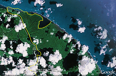
Last week, we were informed of a data error regarding the border between Costa Rica and Nicaragua in Google Maps. We said we would update our data for this region. We have now updated the border data on Google Earth, and we are working on updating this border on Google Maps as well.


As always, you can report errors about Google Earth through our Data Reporting Page or about Maps through the Report a Problem tool, where available.

Thursday, November 11, 2010

Film Locations on Google Maps

Movie Locations Guide

Website Movie Locations Guide has created three Google Maps to show movie locations in three cities, New York, Los Angeles and London.

As well as the three dedicated city maps each film listing in the Movie Locations Guide shows a Google Map for each of the locations listed on the site. For example, if you look up The Big Lebowski five locations used in the film are listed and you can view each on a Google Map.

Filmaps

Filmaps is a film locations website that also uses Google Maps to show the locations of movies. Filmaps want to help movie fans find the locations in their favourite films.

It is possible to search Filmaps for a particular film or it is possible to search a location to see which film was made there. For example, a search for the Eiffel Tower reveals that four films in the Filmaps database have used the famous landmark as a location.

Each film has its own Google Map. When you are browsing a film's locations it is very easy to add another location if you know of one that hasn't already been added. To do so you just press the 'add a location button' and complete a very short form.

________________

Labels:

Real-time Alerts with Google Maps

Alert Map

This live Google Map from the Emergency and Disaster Information Services (EDIS) in Hungary shows the latest earthquakes, volcano eruptions, floods and other disasters around the world. The map also shows the major oceanic rifts and transform faults.

If you click on any of the mapped emergencies and disasters you can click through to view more details on the incident. Beneath the map there is also detailed information about earthquake and volcano activity around the world, as well as news of Earth approaching objects in the next 30 days, tsunami information, geomagnetic storms and the currently mapped emergencies.

________________

Labels: ,

Google Earth: a window to greater learning


We love hearing stories about how people all over the world use Google Earth. Richard Allaway, a teacher at the International School of Geneva - Campus des Nations, recently shared his thoughts on the importance of Google Earth in his classroom. With Google Earth, Richard is able to create a unique experience in which he and his students can travel the world, exploring everywhere from the bottom of the Atlantic Ocean to the peaks of the Smoky Mountains. We loved his story so much, we want to share it with you too!

Here's what Richard had to say:
There are two windows in my classroom. One window looks past the buildings of the International Labour Organization, Geneva's Jet d'Eau, and onwards to the Alps.

Google Earth’s representation of the view from Richard’s classroom window

Through the other window we can see Mount Etna, the meanders of the Mississippi, all the way to the buildings of Ancient Rome and even significant earthquakes that have happened in the last seven days. This “other” window is Google Earth.

I am a humanities teacher at the International School of Geneva - Campus des Nationsworking with students ages 11 to 18 years old. But Google Earth is an important tool in any teacher’s toolbox because it provides a free and accessible gateway to far-off places. I use Google Earth to enhance my students’ learning opportunities and help them better understand the places we discuss. From our classroom, we can visit the landscapes that we can’t normally see through the limited viewpoint of a real window.

For example, we’ve taken a tour through the limestone landscapes of the Yorkshire Dales in the United Kingdom. Guided by a Google Earth tour and supporting worksheet, my students explored the unique limestone features and saw for themselves how geological processes shape our environments.

To study the possible eruption of Mount Rainier in the American northwest, we used Google Earth to visualize the hazards and the corresponding management strategies. Students were then challenged to use Google Earth or Maps to plan an escape route for what is considered to be a low-probability, but high-consequence event.

Information in Google Earth about Mount Rainier

GeographyAllTheWay.com is the website I use to organize and deliver my teaching resources. Students can access it from any location, whether they’re at the library, at home, on their computers and on their smart phones. It’s a continually developing project, but also a service that I welcome my fellow educators to use to help support their own lesson planning.
We love hearing inspirational stories like Richard’s, so if you want to share a cool experience you’ve had using Google Earth, tell us - we’re listening!

Tuesday, November 9, 2010

New Aerial Imagery Released


Google have released new aerial imagery on Google Maps.

Google's aerial view is similar to Bing Map's bird's eye view, giving an oblique rather than an overhead view. The new imagery is available in Tuscon, Arizona. So far I haven't found any new imagery elsewhere but I'm sure there must be more.

This Aerial View Map now includes aerial imagery from Tucson, a number of other US locations and from Venice and South Africa.

Bird's Eye View

This application places Bing Maps' Bird's Eye View side by side with Google Maps' aerial view. You can view the same locations as seen by Bing and Google Maps.

I have added an image from the Pima Air and Space Museum in Tuscon to the map.

The state of the Berlin Wall, 21 years later

It was exactly 21 years ago today that the Berlin Wall fell. In honor of that anniversary, Virtual Berlin has released a very impressive and comprehensive "3D Virtual City Model" using the Google Earth Plug-in.

berlin-wall.jpg

It allows you to view a ton of data about the wall, including some great comparisons between 1989 and today. They use 3D models, historical imagery, and a variety of other tools to make it incredibly feature-rich.

Finding a lost family with Google Earth

A neat story from British Columbia yesterday; a family was hiking on Mount Tzouhalem this past Sunday when they got lost in the dark on their way back down the mountain. When calling for help, they described the area around them (fences, horses, etc). One of the search managers started up Google Earth, found an area that matched their description, and helped lead to their rescue!

As you can see in the image below, the mountain is in relatively high-resolution in Google Earth, which helped make this possible:

tzouhalem.jpg

If you want to check out the mountain for yourself, you can fly there using this KML file. For more info, check out the full story on BCLocalNews.com.


jQuery and Google Maps

jQuery is a JavaScript library designed to simplify the client-side scripting of HTML. Over the years a number of JQuery demos and plugins have been developed to help you create Google Maps for your website. Here is a quick round-up of some of the best jQuery and Google Maps implementations:

Google Maps Slider

This nice Google Maps demo applies a mouseover event to a map sidebar. When you mouseover a listing in the sidebar the map pans to the selected location.

JQuery & Google Maps Tutorial

This is a great tutorial about how map developers can use JQuery to create custom Google Maps. I particularly like Step 7. of the tutorial which shows you how to replace the default information window in the Google Maps API with a custom information window.

Rotating Map Demo

Chris Heilmann has created his own rotating map demo using CSS3 and jQuery.

Use the 'L' and 'R' keys to rotate the map. Also try and pan the map for a little added fun.

Chris has posted a brief explanation on his blog Wait Till I Come! that will help you if you would like to replicate this effect in your own maps.

Google Maps Google Maps jQuery Plugin V1.01
Shawn Mayzes has created this jQuery Google Maps plugin. The plug-in includes a lot of features including custom map markers, geocoding and adding a Street View overlay.

imGoogleMaps 0.9 - Street View

imGoogleMaps is another jquery plugin with a full set of features. I have included it here because it is one of the few jQuery plugins that allow you to display Street View and a Street View control.


If you want to explore more jquery plugins Drag & Drop has a nice post, 10 jQuery Plugins for Easier Google Map Installation.

Monday, November 8, 2010

Google Search app for Windows Phone 7 - in the Marketplace now

Searching with Google on your Windows Phone 7 device just got easier. The Google Search app for Windows Phone 7 provides quick and convenient access to a rich set of search results, allowing you to search the web, images, local, news, and more.

This initial release of the Google Search app includes several features that help you to search faster - suggestions appear automatically as you type, you can choose to repeat a query from your search history, and your current location is used to provide more relevant results.


The Google Search app is a free download for all Windows Phone 7 devices and languages. Just search the Marketplace for “Google Search”, download, pin to Start, and the power of Google Search is only a click away.


Update: we have flipped the switch for the app to go live, but it doesn't seem the app is showing up everywhere just yet.

Movember Earth

Invented in 1999 by a group of Australians, the Movember Foundation fights to raise awareness and funds for a variety of men's health issues, such as prostate cancer. The word "Movember" is a combination of "Moustache" and "November"; growing a moustache during November is essentially the trademark symbol of the group.

GEB reader 'Damien' is a participant in the event, and decide to help give it a bit of promotion. Similar to our Halloween tradition of turning Google Earth into a pumpkin, Damien turned the earth in a giant smiley face with a moustache!

movember.jpg

You can download the model from the Google 3D Warehouse or download the KML directly.

You can learn more about the Movember Foundation at movember.com.

Virtual Tours with Google Maps

youVR

YouVR is a website that allows you to build embeddable virtual tours using photographs, videos and Google Maps.

Using youVR it is possible to create an online tour consisting of a Google Map with interactive hotspots that include photographs and/or videos. When you have created a tour you can an embed it in a website or blog by cutting and pasting a short piece of code.

You can also browse other users' tours on the Most Recently Added page on youVR.

Remembering WWII with Google Maps

Second World War Casualty Map

Just in time for Remembrance Day Patrick Cain has released this Google Map commemorating the 3,224 Torontonians who died in World War II.

During the Second World War Toronto kept a file of typed index cards at the city clerk’s office of soldiers killed in action or at German prisoner of war camps. The cards fill 12 boxes. Patrick has spent over 55 hours digitising the records and then geocoding the records to the homes listed as the next-of-kin address of those killed.

The result is this Google Map of Toronto residents killed in the war. The poppy shaped map markers indicate addresses. Where two or more people were killed in a household a number is displayed to show how many.

Patrick Cain has written a post on Open File called Remembering Toronto's Fallen from World War II. The post explores his reasons and methods for creating the map.

World War Two Timeline Project

The World War Two Timeline Project is an interesting attempt to chronologically and geographically, map the events of World War Two using the open source Simile Timeline. Using the map it is possible to view the major events of World War Two on a Google Map.

You can use the timeline, at the top of the map, to plot the progress of the war on the map. It is also possible to navigate the events of the war via tags. These tags include countries as well as subjects such as naval, aerial and land. The map creators say they have not finished adding data, so this map should become an even more useful resource over time.

Declassified Military Aerial Images Map

The Royal Commission on the Ancient and Historical Monument of Scotland are busy mapping declassified military aerial photographs on Google Maps.

The Aerial Reconnaissance Archives have millions of military reconnaissance images of locations throughout the world declassified by the UK Ministry of Defence. The archives range from Second World War Allied and German Luftwaffe reconnaissance photographs to Cold War imagery.

To date RCAHMS have mapped reconnaissance photographs in Belgium, Croatia, the Czech Republic, Denmark, France, Germany, Italy, the Netherlands and Poland. Using Google Maps to display the photographs means that users can compare the present day satellite view of locations with reconnaissance images from the past (mostly from World War II).