Monday, August 30, 2010

First Google Map with Facebook Places

Nearby Friends

Nearby Friends is a Google Maps based Facebook application that utilises the new Facebook Places check-in facility. The application allows you to view all your friends check-ins on one Google Map.

Nearby Places doesn't just show your friends' latest check-ins it also allows you to visualise their entire check-in history. If you click on any of your friends' thumbnail pictures displayed on the Google Map you can choose an option to view their 'Check-in History'.

When you select to view the check-in history of a friend you are presented with a Google Map showing all their check-ins. Each check-in is represented by a profile picture. The larger the picture the more recent the check-in. Each individual check-in is also connected to the next check-in with a polyline. Therefore you can click on the largest profile picture and track your friend's check-ins backwards all the way to the womb (well maybe not that far). 

Introducing our new YouTube channel for Google Mobile

By now, some of you may have noticed our new Google Mobile YouTube channel, with a fresh look that includes a video box that rotates along multiple axes (we love the Rubik’s Cube here at Google). As you click on and discover more videos, we hope you’ll have fun checking out all the ways the box can turn.

In our channel’s “featured” section, we highlight some of our mobile search capabilities -- like search by voice, sight, and location -- that really help you take advantage of your phone’s unique technology. Since we understand that these represent new modes of searching for many of you, we’re going to launch some new videos that help illustrate the variety of practical and fun ways that you can use these features. To start with, check out our “Shoot This” series of videos for Google Goggles. Goggles can actually recognize much more than just bar codes and book covers, and these videos really let you take Goggles for a test drive. You can navigate through these videos by clicking on the embedded annotations to fast-forward or rewind.

When looking at “all apps,” you can not only check out any of our latest videos at a glance, but also quickly sort them by mobile platform or by app.
We’ve also made it easier for you to share videos by email or through popular social networking sites.

We hope you enjoy trying out our new Google Mobile YouTube channel. We’ll be adding many more new videos, so please visit youtube.com/googlemobile and subscribe. Also, if you’ve already subscribed to our old channel, note that you need to subscribe to the new one separately.


Street View and The Wilderness Downtown

Some of us now live far away from the places where we grew up, and I’ve often found something quite evocative and wistful about looking at photos of the streets where I used to live. A few of us decided to capture this feeling of nostalgia in an interactive music experience that we developed for the web.

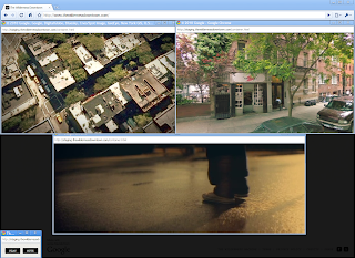
The music experience, called “The Wilderness Downtown,” was created by writer/directorChris Milk, with the band Arcade Fire and several of us at Google. Drawing upon Street View in the Google Maps API as well as features made possible by HTML5, we created what we hope is a unique and deeply personal experience of traveling 
down the streets where you grew up. All this is set to Arcade Fire’s new song “We Used to Wait” off their newly released album “The Suburbs.”


“The Wilderness Downtown” was made possible by recent developments in modern web technologies and modern browsers, and was built with Google Chrome in mind. As such, it’s best experienced in Chrome or an up-to-date HTML5-compliant browser.

You can launch the project and learn more about it on our Chrome Experiments site atwww.chromeexperiments.com/arcadefire. Enjoy the trip down memory lane!

A Google Maps Based Music Video

The Wilderness Downtown

This impressive Google Chrome experiment combines video, Google Maps and Google Street View and choreographed multiple windows to help demonstrate what is possible with HTML5. The experiment is an interactive interpretation of Arcade Fire's song "We Used To Wait" and was built entirely with the latest open web technologies, including HTML5 video, audio, and canvas.

The Google Map tiles used in the experiment are rendered, zoomed, and rotated in a scripted 3D environment. Animated sprites are composited directly over Google Maps satellite and Street Views. The animated sprites include flocking birds and animated trees.

The Google Maps API is also used for fetching dynamic routes to user chosen destinations and checking Street View content at points along the route. With so much going on the experiment is very processor intensive. It took about ten minutes to load on my desktop but the wait was definitely worth it.

Hat-tip: Street View Funny

Murder Maps

MurderMap

The Murder Map project aims to create the first ever comprehensive picture of homicide in London. On its completion, the developers say it will contain details of every murder and manslaughter committed in London from the crimes of Jack the Ripper to the present day.

At the moment the map seems to show murders in the UK capital just for 2010. You can filter the results shown on the Google Map of homicides by murder weapon.

All Murders Washington DC 2005-2009

Burgersub.org have a number of Google Maps that visualise murders in Washington DC and Baltimore. The maps include this Google Map of all Washington DC murders from 2005 and 2009.

Baltimore Sun - Baltimore Homicides

The Baltimore Sun has a Homicides Map that allows you to view all murders in Baltimore since 2007. The map allows you to refine the results by date, location, gender, race and cause of death.

New Orleans Murder Map
Shows homicides in the city in 2009.

LA Times Homicide Report

The LA Times uses Google Maps to show murders in Los Angeles. You can search the map by year, address or by name.

New York Times Homicide Map
The New York Times Homicide Map show murders in the Big Apple by year. The map includes a number of search options to refine the data by race, age, sex, murder weapon and locality.

Orlando-Area Murder Map 2010
This map from the Orlando Sentinel shows the locations of homicides committed this year.

Homicides in San Francisco 2007-2009

Google Map of San Francisco murders from the San Francisco Chronicle.

Birmingham, Alabama Murder Map
2009 murders in Birmingham visualised on Google Maps.

Drab i Danmark 2010
This map uses the SIMILE time-line with Google Maps to show murders in Denmark.

Hurricane Katrina, Five Years Later

Yesterday marked the five-year anniversary of Hurricane Katrina making landfall in New Orleans, Louisiana, causing over $80 billion in damage and killing nearly 2,000 people. Google Earth Blog offered a great deal of coverage to the event, as Google was able to contribute a variety of imagery updates and other resources to help. I had just started running Google Earth Hacks at that time, and users submitted quite a few KML files related to the hurricane.
Despite only being on the market as "Google Earth" for a few months (it was previously available as "Keyhole", though it was far less popular) many people, such as this couple, were able to use Google's oft-updated imagery of the area to see the condition of their home.
superdome-katrina.jpg
In early 2007, after having posted post-Katrina imagery in Google Earth, they reverted the default layer to pre-Katrina imagery. While this was only done to insure the highest quality imagery, Google caught a lot of flack for this and resolved it a few days later.
Late last week, Google posted a short entry that recognized the anniversary of Katrina. As they mention in the article, Google Earth's historical imagery tool is a great way to look back and see how the city changed from pre-Katrina, after the storm hit, and how it looks today.

Escalator Down at Metro Station

TBD.com: Map of WMATA Problems

TBD.com have used the Ushahidi Google Maps reporting system to create a map of Washington Metropolitan Area Transit Authority problems. The map allows TBD.com's readers to see at a glance where there are current problems on Washiongton's transit system.

Using Ushahidi's reporting system allows TBD.com to crowdsource current problems on the WMATA. Users are able to report problems by directly submitting a report, tweeting an alert with hashtag #tbdwmata or by emailing an alert.

Submitted problems on WMATA will automatically appear on the Google Map. The reports are also listed under the map in chronological order.