Thursday, July 29, 2010

Rain or Snow, Now You Can See Weather in Google Earth

It’s the middle of summer, but for those of us who long for the return of cold winter weather and warm cups of cocoa, throw on your favorite poncho and check out the weather in Google Earth 5.2. The latest version projects images of rain and snow over the areas with those weather patterns as it’s actually happening! First enable the clouds layer, then zoom in to a particular location where it might be raining or snowing. I’m willing to bet London is a likely spot, even these days, or the Lone Star state (pictured below) which is in the midst of tropical storm season. Currently, our precipitation data cover some areas in North America and Europe; you can see if it’s available in certain places by enabling the radar layer.


This is a fun and useful tool for anyone planning to travel or who wants to check a specific area where a friend of relative might be visiting or living. For example, in preparation for my recent trip to the American southwest, I decided to check on the status of Hurricane Alex a few days in advance:


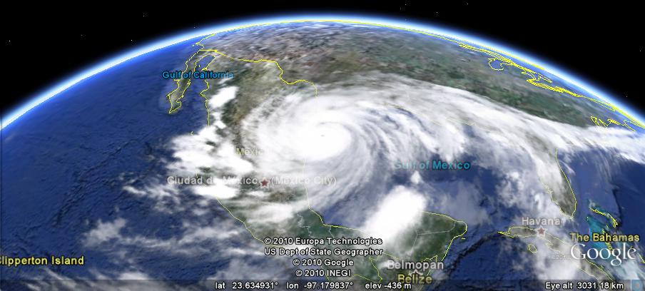
Via Google Earth, I could see that the hurricane was entering Mexico and Texas. Zooming close to ground, I saw that the Texas coastline was getting a bit of rain:


Luckily, I missed the hurricane by a couple of days!

You, too, can make like a meteorologist and track wet weather patterns ranging from light drizzle and snow to hurricanes and blizzards in Google Earth. Feel free to give it a try!

3D Satellite View with Google Maps

Stereoluchtfoto's van Amersfoort uit 1932

In July 1932 a plane flew over the Dutch city of Amersfoort and took 160 stereoscopic aerial photographs. Wessel Spoelder has pieced together 32 of these photographs and created this Google Maps mashup.

So if you have your 3D glasses hanging around after viewing Street View in 3Dput them on and check out Amersfoort from above in 3D. If you know Amersfoort you can even search the map by street name.

This is another great Google Map from ab-c media weblab whose panoramicStreet Views of churches in Utrecht is one of the most impressive maps I've seen this year.

The Orient Express Route on Google Maps

London to Istanbul by Train

One of my life's ambitions is to take the train from London to Istanbul following the route taken by the Orient Express. Guardian journalist Benji Lanyado did just that and has created this video map of his journey.

The map itself is just a simple My Map embedded on The Guardian website. The videos however are top-notch and definitely worth watching. They are even better, in my eyes, for having been uploaded to YouTube with the user name pottsy4england (there are bonus points available for the first person who can explain that name in the comments).

The nearest I have got to realising my ambition is creating this Google Map mashup of the route, The Orient Express, featuring a number of videos of cities along the journey. The map is a couple of years old now but still works OK.

Subway Traffic on Google Maps

New York City Subways

Here is another great example from the New York Times of a Google Map created to help illustrate a news story.

Every year, New York City Transit releases a station-by-station breakdown of ridership on the network. This NYT article examines which subway stations experienced a decline in traffic last year and which subway stations experienced growth.

Readers of the New York Times can use the Google Map to query the data themselves. The map gives a great overview of the yearly rises and falls of traffic and users can click on any subway station to view specific traffic data.

The map includes three main views which can be accessed via the menu at the top of the map. You can view a map of where ridership is down, where ridership is up and view the total traffic for the year.

Other New York Times Google Maps

Biking across Poland


GEB reader 'fjk' has recently completed a bicycle trip across much of northern Poland, and he did a great job of tracking the journey and augmenting it with photos and other information.
fjk-trip.jpg
A group of four of them completed to the trek to Swinoujscie, and they used a Garmin 60CSxto track their route.
To view the trip in Google Earth (as seen above), you can simply load this KMZ file. To see more of his adventures, check out his website.
It's great to see people sharing their journeys using Google Earth. If you missed it last month, a few GEB readers used the new "track" feature in 5.2 to show the progress of a 23km race that one of them participated in.
If you've created an interesting track in Google Earth recently, let us know about it and we may feature it in a future post.

World Motor Sports on Google Maps

Rally-Maps.com

Rally Maps uses Google Maps to show the locations of rallies all over the world. Rally Maps also maps a lot of rally videos.

If you click on a rally marker you can then select to view the rally's route marked out on the map. The route includes indicators to show the start and finish locations, spectator locations, the schedule of races and an elevation profile.

Users of Rally Maps can add their own videos to the maps. They can also add their favourite spectator locations for the different rallies.

Ordering Food with Google Maps

Go Mobo

Go Mobo allows users to place online and text message orders at their favorite restaurants.

To place an order diners first have to find which Mobo restaurants are nearby. To do this you just need to enter an address or zip-code. Go Mobo then displays a Google Map of restaurants in your location. The restaurants are also listed in the map sidebar, with the address, distance from your location and opening hours.

If you select a restaurant from the map you can then click through to the restaurant's menu and select what you wish to order. Once you have placed your order all you have to do is turn up, collect your food and eat.

Bike Thefts on Google Maps

Oak Park and River Forest Bike Theft Map

I cycle almost daily. My experience is that I have a bike stolen on average every other year. So over the years I've worked out that in the long run it is probably best to buy only the cheapest bikes in London.

I couldn't agree more then with the The Wednesday Journal of Oak Park and River Forest when they say that the "best way to avoid thefts is to be smart and informed". To help residents in this suburb of Chicago keep informed The Wednesday Journal are creating a Google Map each week to show the locations of bikes stolen

The map shows whether bikes were secured or unsecured when stolen and also shows arrests made related to the theft of a bike. Looking at the map there seems to be a cluster of thefts around South Boulevard. My guess is these are bikes mainly left at subway stations on the Green Line.