Friday, October 29, 2010

Google Map of Schools & Pot Dispensaries

School-Pot Map

Marijuana policy is a hot topic in California right now. Proposition 19, which would legalise various marijuana-related activities, is being voted on next Tuesday.

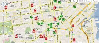
In an effort to help inform voters School-Pot Map shows the walking distances from San Francisco public schools to the nearest marijuana dispensary. For example, Marshall Elementary is only 142.2 yards from the nearest dispensary.

The marijuana dispensaries and the school locations are based on data from the San Francisco Department of Public Health and the San Francisco Unified School District.

3D panoramas of the protests in France

We first mentioned the excellent 360cities.net more than two years ago, and the site has been improving ever since.

They often post panoramas of current events and while the protests in France seem to be easing up, they were quite a big deal for a few days. 360cities captured some stunning panoramas of the protests, such as the one below:

They have quite a few more of them, and they're equally striking. Check them all out on the 360cities blog. You can also view panoramas from 360cities directly in Google Earth using their layer.

Have you submitted any panoramas to 360cities? Leave a comment and share the link with us so we can check it out.


Friday Fun with Google Maps

Fartsquare

It looks like Foursquare could have a new rival.

Via: TNW

Strangely Shaped Road

What will those soccer hooligans get up to next? It appears that Google aren't fans of English soccer team Newcastle United as they have drawn a huge penis over their ground, St James Park.

Street View Mural


Street View Funny found this superb mural in Montpellier, France.

Via: Street View Funny

Area 51 - Google Reviews

If this review for Area 51 is anything to go by not everyone is happy with the service they receive at Area 51 in the USA. The text reads:

"Poorly treated. I found that on arriving from my home planet of Diuahdhajissiannsa I was brought to this horrible place. I was extremely mistreated and was often probed. Would not recommend."

_____________

Thursday, October 28, 2010

Find a Job in Finland with Google Maps

Duunitori.fi

Duunitori.fi is a Finnish jobs search website that uses Google Maps to help users find jobs near their location.

Using the map users can search for jobs by location and by type. After you have entered your location and the areas of work you are interested in the resulting jobs are displayed on the map.

Duunitori.fi have devised their own clustering system which works very well. If you zoom out of your chosen location Duunitori.fi automatically loads more markers onto the map and can cope well with thousands of markers.

was developed by cloudingsky

Via: Esa

Dutch Random Street View Locator

StraatBlik

Random location and Street View generators seem to be all the rage at the moment. Here's another one.

Straatblik generates a random Street View from Google Maps' imagery in the Netherlands. To move to the next random view just press 'Volgende'.

My first random find was what looks like the world's largest spinning top. What can you find?

Bring Your Phone to Work Day: Managing Android Devices With Google Apps


With over 200,000 devices activated each day, Android is seeing rapid adoption, and today we are launching new administrative controls that make it possible to securely manage these devices in the Google Apps environment. With this launch, Google Apps provides a comprehensive mobility solution for all major mobile platforms. You can manage most mobile devices right from the browser, without having to deploy dedicated servers.

Many Android devices feature tight integration with Google Apps, including native applications for Gmail, Google Talk, and Google Calendar, as well as mobile access to Google Docs. Now any employee with an Android device running version 2.2 - personal or company-issued - can access their corporate information while allowing administrators to enforce data security policies such as:

  • Remotely wipe all data from lost or stolen mobile devices
  • Lock idle devices after a period of inactivity
  • Require a device password on each phone
  • Set minimum lengths for more secure passwords
  • Require passwords to include letters and numbers
When the employee leaves the company, the administrator can withdraw access to corporate info, which allows the employee to continue to use their device if it’s their own

These policies can be enforced on devices that have installed the Google Apps Device Policy application, which will be available from Android Market in the next few days. They will be available free to all Google Apps Premier and Education Edition customers in the next few days, and can be accessed from the 'Mobile' tab under 'Service Settings' in the Google Apps control panel.

To learn more about these updates in mobile device management for Google Apps, join us for a live webcast with Mayur Kamat, Google Apps Product Manager, on November 10, 2010 at 9 a.m. PDT / 12 p.m. EDT / 6 p.m. GMT. Register now

New in Google Maps for Android: Updated reviews, search filters, and Latitude real-time updating

Lately, we’ve been working on giving you even better ways to find nearby places with Google Maps for Android, such as the Places icon and rich Place pages. Today, we are launching Google Maps 4.6 with a new design for Place page reviews, more options to filter search results, and a Google Latitude real-time updating option.

Place page reviews
Now, you’ll see that Place pages on Android Maps share the same new design for displaying reviews as used by Place pages on your computer. You can see:

  • “Reviews from around the web” for highlighting sites that have high-quality reviews about the place.
  • “Reviews from Google users” for reviews posted directly to Google Maps by other users
Filter search results
Of course, you’ll first need to narrow down which Place page reviews to check out. In addition to distance and ratings, you can also filter results for some searches by:
  • Open now
  • Neighborhood
  • Related searches

Find the right place with the updated reviews section (left) or search results filters (right).

Google Latitude real-time updating
In Latitude, you can also choose an experimental “Real-time updating” option from an individual Latitude friend’s profile page to help meet up with them by temporarily seeing faster location updates (friends must have Maps 4.6 and Android 2.2+).

Get Google Maps 4.6 for Android 1.6 and above everywhere Maps is already available. Just search for Google Maps in Android Market (or tap here from your phone).

Visit our Help Center to learn more or tell us your feedback and questions in our Help Forum.

See How Cities Connect on Google Maps

Autobiopic CityLinks

Autobiopic is a Google Maps based tool to visualise your Foursquare check-ins. The application allows you to animate your recent check-ins on Foursquare and return the distance you have travelled.

Autobiopic has now developed a very cool visualisation tool called Autobiopic CityLinks. This new visualisation tool uses Google Maps to measure the connectivity between cities based on the number of visitors to Autobiopic who have checked into both of those cities.

If you enter a city into the search box you can view a map showing you the connectivity of Autobiopic users. The map shows where people from the city travel by drawing a line from a check-in made in the searched city to other cities that the Foursquare user has travelled to.

There are already 1,500 cities in the CityLinks database so you should be able to view a CityLinks visualisation for most of the major cities around the world.

Route Savvy App - Bing Maps

Whether you are going five or fifty places, the Route Planner app is a useful, unique map app that will get you from point A to Z in the shortest amount of time possible.Route Savvy App  Bing Maps

Find Shortest Routes or quickest routes with traffic and managing geocoding from Excel data.

How it Works

Route Savvy App Geocode - Bing Maps

The first step is to add destinations on the map. “RouteSavvy” makes it easy to quickly add a few or 100 destinations – you can click locations on the map, enter addresses manually on the left-rail, or upload an Excel file with addresses on each row. For demonstration purposes, I’ve shown eight points below. Each time you add a destination, the map auto-zooms and centres so you can see all the destinations at once.

Route Savvy App Import Excel - Bing Maps

"General users likely have between three and ten destinations when they plan trips that could benefit from route optimization. The value of this tool for business use is amplified when businesses may have 25 or more destinations to reach in a day. Other servicesonly allow up to 25 waypointsconsidering the Bing app can handle up to 100, we feel that we’ll be a strong choice for businesses who need great route optimization for lots of destinations. Realtor's who have multiple showings in a day, any business that does deliveries, shuttle services, technicians, and florists – just a few examples - will find this to be a great tool to make their lives easier with the “RouteSavvy” app."

View the new Map App: OnTerra’s “RouteSavvy” Route Optimizer

a

Google Maps Collages

Jenny Odell's Satellite Collection

Graphic Designer Sarah Odell has created a series of beautiful digital collages using cut-out imagery from the satellite imagery on Google Maps.

The image above is made up of various cargo ships and other boats found on Google Maps. The other digital prints include collages of swimming pools, grain silos & water towers and square mile images from the Great Salt Lake.


Also See

  • Apres Garde - Beautiful images found on Google Street View
  • Lehel Kovács - Hungarian designer using Google Street View as the starting point for
  • cityscapes
  • Virtual Paintout - paintings inspired by Google Maps Street View

Wednesday, October 27, 2010

Iraqi Civilian Deaths on Google Maps

Map of Iraqi Civilian Deaths on Familiar Locations

Mike Brennan has used the WikiLeaks Iraq War Logs to create a Google Map of civilian deaths in Iraq over a five year period.

The map uses the WikiLeaks data and Fusion Tables to show you the location of all the civilian deaths in Iraq. To help users get a little more perspective of what 65,649 deaths looks like you can overlay the data on maps of cities that you are familiar with.

For example, if you click on the New York City link you can view the same data transposed to the Big Apple:


The full list of cities that you can overlay the data on is: New York City, Washington, DC, Philadelphia, San Francisco, Los Angeles and Chicago.

Also See

Weather Forecasts with Google Maps

The Weather Land - Global Forecast System

The Weather Land uses Google Maps to show the current weather at your location or for any chosen location around the world.

When you first visit Weather Land the application automatically detects your location and displays a custom precipitation map for your country. You can then click on the map to load cities in the map sidebar.

If you click on any of the cities in the sidebar the local weather forecast for your chosen location is displayed. The weather for the next three days is loaded showing the forecast temperature, wind and precipitation.

_____________

Evolution: European OpenStreetMap


Evolution of European OpenStreetMap coverage from skobblertutorialson Vimeo.

Hence why Mapquest(Open) and Bing Maps (OSM App) are becoming more mainstream

Labels: , , , , ,


Sunday, October 24, 2010

Wikileaks Iraq War Logs - Part Two

A Day in the Life of the War

WikiLeaks has released the largest classified military leak in history, around 400,000 secret field reports from Iraq. The Guardian's - Every Death in Iraquses Google Fusion Tables to map every death in Iraq as found in the Wikileaks Iraq war logs.

The Guardian have also used Google Maps to visualise one day in the life of the war in Iraq. The day in question is 17th October 2006 in which 136 Iraqis were killed, 10 Americans died and hundreds of violent incidents occurred. The Guardian's visualisation maps the logs over the 24 hours minute by minute.

The visualisation uses a static Google Map with an interesting transparent overlay, the opacity of which is changed to reflect the time of day, making the map darker during night-time and lighter during the day.

Eksta Bladet - Vejsidebomberne i Irak

Danish newspaper Ekstra Bladet has used Google Fusion tables with Google Maps to map the attacks on the allied forces by roadside bombs (Improvised Explosive Devices).

Ekstra Bladet has analysed the 400,000 WikiLeaks Iraq war logs which show that nearly half of the fallen soldiers from the international forces were killed in attacks by roadside bombs: 2,065 soldiers were killed and 16,949 were injured.

The data for the map can be found in this Fusion Table.

Zoom Ind på Alle Rapporterne

Ekstra Bladet have also created a Google Map that shows all of the 391,832 war log reports.

The map uses the Maptimize marker clustering solution to effectively display the 391,832 markers.

Via: www.microformats.dk

WikiLeaks War Logs
WikiLeaks have themselves included a Google Map on every one of the war logs to show the location of the incident reported. You can search the war logs at WikiLeaks by type, date and location.

You can also download the data from The Guardian's Datablog.

Also See

UK Walking with Google Maps

Take a Walk

Clover in the UK have produced this Take a Walk campaign to encourage the British to get outside and do some walking. The site includes over 25,000 walking routes throughout the UK, ranging from 0.1 to 30 miles.

Using the site you can search for a nearby walk by address and distance. The resulting walks are then presented overlaid on Google Maps. All the routes for the campaign have been provided by MapMyWalk.

Via: Mapperz

Treasure Trails

Treasure Trails create fun treasure hunts around villages, towns and cities in the UK. Currently there are over 5oo Treasure Trails in locations all over the UK.

Treasure Trails provide a Google Map for each UK county showing the location of the available treasure trails in the region. To select a trail just click on one of the map markers. Unfortunately to actually view and print the trail you will then have to pay a small fee (£5).

The EPA Mobile App with Google Maps

myRight-to-Know

The United States Environmental Protection Agency has released a new mobile application that displays nearby facilities that report to the Toxics Release Inventory. It also displays the location of large permit holders in the Air, Water or Hazardous Waste programs that are expected to produce, manage or release TRI-reportable chemicals.

Using the app you can search for any address to view the results from the TRI for that location. The blue markers displayed on the map show facilities that submitted Toxics Release Inventory (TRI) reports for 2008. The grey markers show facilities that did not report to TRI for 2008 but that have other EPA records indicating they may release or manage TRI-reportable chemicals.

The myRTK test version is currently compatible with Firefox and Chrome browsers, and is not currently compatible with Internet Explorer. To access the test version of the myRight-To-Know application, visit m.epa.gov/myrtk from your mobile or desktop device

Wikileaks Iraq War Logs on Google Maps

The Guardian - Every Death in Iraq

WikiLeaks has released 400,000 secret field reports from Iraq. Wikileaks claim it is the largest classified military leak in history. The Guardian has used Google Fusion Tables to map every death in Iraq as found in the Wikileaks Iraq war logs.

If you want to create your own Google Maps visualisation (maybe adding a timeline) you can download the data from The Guardian's Datablog.

Also See

Friday, October 22, 2010

Friday Fun with Google Maps

Holy Bat Pools Batman

It seems Batman has been travelling the globe. Gizmodo recently found this large bat signal on Google Maps,


And IO9 has found Batman's Japanese Batcave in Okinawa.


Gawker Finds God

Not to be outdone by Gizmodo and I09, Gawker has discovered God floating above a lake in Quarten, Switzerland on Google Maps Street View.

Street View Driver Risks Imprisonment

In Ireland the Google Street View driver has bravely risked imprisonment by ignoring this no photography sign.

Via: Street View Funny

Google Maps Reflection

Pamela Fox of Google has created this rather nice reflection effect for Google Maps.

China's "Google Earth killer" launches

China's State Bureau of Surveying and Mapping today released their long-anticipated web-based mapping tool, Map World (天地图), Reuters reports. it's located athttp://www.tianditu.cn/ and you can give it a go right now; it's in Chinese only but the controls are intuitive enough.

mapworld.jpg

Just some very brief observations, as I have a flight to catch:

  • The 2D mapping tool, which lets you toggle between maps and satellite imagery, is available both for Mac and Windows browsers, and requires no additional plugins. Mapping tiles loaded quite responsively for me.
  • Imagery of Shanghai Expo 2010 and Beijing's Tiananmen Square is more recent than Google's imagery. Imagery of Kashgar is older than Google's imagery.
  • Unlike in Google Maps, Map World's projection squashes imagery and maps in the north-south direction. The Forbidden City is distinctly more square, and round buildings in Shanghai Expo are portrayed as oval.
  • The 3D viewing tool requires you to download and run "GeoGloberuntime.exe" as a web plug-in, so obviously it is a Windows only tool. Once installed, it promptly crashed my copy of Internet Explorer 9 upon use, so I can't report back more right now. I couldn't find any mention of a GeoGlobe runtime online, so I'm not sure if this is from a third-party vendor or home-grown. (In any case, beware installing software from a Chinese government agency website).
  • The maximum resolution for imagery in China (the only place I went looking) is lower than in Google Earth. I briefly went searching for censored content: Near the "secret" underground submarine base in Shandong province, tiles above a certain resolution simply don't load for me. I can't yet tell if this is the standard way of censoring Map World.
  • The 2D web mapping tool comes with area and distance calculators, as well as a feature editor. These are accessible via the links along the tool bar running above the map.

Overall, Map World feels quite robust, far more so than the France's GeoPortail and India's Bhuvan at launch. If you do get the 3D plugin to work over the weekend, please let me know.

Google releases a lot more 65 year-old historical imagery

We're big fans of Google Earth's "historical imagery" tool. We gave another overview of it last month, then followed up a few days later with a list of eight things you might use it for.

Google doesn't often announce releases of historical imagery, with the the most recent being more than eight months ago. However, Google has just pushed out historical imagery that covers nearly all of London from 1945!

map-room.png

This update includes a ton of great imagery. Another example they provide is of London's Heathrow Airport, 1945 and today:

heathrow.png

What other great things can you find in that old imagery?

Take a Walk - Clover Campaign

With over 25,000 walking routes throughout the UK. Short to long walks are available ranging from 0.1 to 30 miles.


Take A Walk Clover Maps
After entering your rough walk preferred location and the distance you are wanting to walk.
Some preset maps are also available.

Take A Walk Clover Maps
You chosen route is overlaid on a Google map and mileage markers are represented.
Routes can be printed or emailed/tweeted for later use or sharing.

Clover is behind the campaign with the routes provided byhttp://www.mapmywalk.com/

Find a Route with Clover
http://www.cloverfamily.co.uk/find-a-walk/

Labels: , , , , ,

Thursday, October 21, 2010

Voice Search in Russian, Polish, Czech and Turkish

Over the past few weeks we have launched Voice Search in four new languages: Russian, Polish, Czech and Turkish. Now, users in the Russian Federation, Poland, the Czech Republic and Turkey can simply say, in their own language, what it is that they are looking for. Try speaking queries like “концерты Юлии Савичевой” (tour dates for Yulia Svicheva), “przepis na pierogi” (recipes for pierogi), “obrázky Hradčan” (pictures of the Prague castle), or “istanbul hava durumu” (weather in Istanbul). Note that you will need to change your language setting on your phone and can’t speak all these languages into the app without changing your language setting first.


Voice Search is often preloaded on new Android devices. In that case, all that the user has to do is press and hold the search button and then start speaking. Some Android (2.0 or higher) phone users can download the Voice Search application from Android Market. On iPhone and other smartphones, Voice Search is a feature of Google Mobile App and is downloadable via m.google.com

French Demonstrations on Google Maps

360 Cities

A member of 360 Cities has posted a number of interactive panoramas of the demonstrations against the pension reforms in France.

You may have seen on the news this week that France has been hit by a number of strikes and demonstrations by workers angry at the government's attempt to raise the pension age from 60 to 62. These panoramas capture the demonstrations in Quimper in north-west France.

No one does demonstrations quite as well as the French. So if you want to experience a bit of virtual Gallic rebellion then check out these panoramas:

one
two
three
four
five
six
seven

New KMLs for Panoramio photos in Google Earth

Panoramio has just updated their network link KMLs that are used in Google Earth to make them faster and more useful. Not only is the link faster, but "The algorithm that is responsible for distribution and taking care of thumbnail overlaps has been improved as well and that is the reason you will now have a feeling of density that did not exist before, together with a better discoverability of the photos in the layer."

As you can see in the photo below, the new versions of the KML files show a lot more photos than before:

panoramio-kml.jpg

As they mention in their blog entry about this update, here is how you can download the various KML files:

1. Popular photos in Google Earth: http://www.panoramio.com/map/
(click on the link in the lower-left corner of the Site)
2. Popular photos in Google Earth (Including photos not selected for the Panoramio layer in Google Earth): http://www.panoramio.com/map/
(you need to select the box before downloading the file from the lower-left corner of the Site)
3. Recent Panoramio uploaded photos: http://www.panoramio.com/map/
(select the recent tab and then click on the link in the lower-left corner of the Site)
4. Photos from a specific tag: http://www.panoramio.com/tags
5. Your Photos: Go to your page http://www.panoramio.com/user/user_ID and click on the link that says "in Google Earth"

We've talked about Panoramio quite a lot over the past few years, and they get better with each update.

Have you uploaded many photos to them? Will you be adding more now that this feature has become even more useful?


Banned Books on Google Maps

Banned Books Map

This has to be one of the saddest maps I've seen in a while.

This week is Banned Books Week. Sponsored by the American Library Association, the American Society of Journalists and Authors and several other groups, Banned Books Week has been documenting the more than 1,000 books that have been banned at U.S. schools and libraries since it was first launched in 1982.

The map shows the locations of where books have been banned in the United States. Reading the books that have been banned, the ridiculous reasons for their banning and some of the disciplinary action faced by teachers and librarians for simply doing their jobs you can't help but weep for the small minded mentalities of some Americans and the lack of backbone shown by some of those in charge of our libraries and schools.

Sorry - rant over. The map itself is a very simple Google My Map but it works fairly well in showing the geographical distribution of books being banned.

Helping Schools with Google Maps

Fuel Your School

In California Chevron recently ran a Fuel Your School promotion. For every 8-gallon or more fill-up at a local Chevron station Chevron donated $1 to help support public education. The promotion was designed to help provide local public schools with supplies that teachers need for their classroom projects.

Chevron have now created a Google Map to highlight how and where Chevron donations are helping to fund classroom projects.

Using the map you can select to view the results for any city from a drop-down menu. Markers are then placed on the map to highlight the schools in the city that have been helped. If you click on a map marker you can read about how the school has benefited from Chevron's programme.

Wednesday, October 20, 2010

Flickr Boundaries on Google Maps

Boundaries

This Google Map of Flickr's crowdsourced boundaries is great fun as it allows you to check your notion of area boundaries with Flickr's crowdsourced definition.

Photo sharing website Flickr suggests a selection of place names when users geotag their pictures. These place names are used by Flickr to compute the shape of geographical areas. These area boundaries are then feedback into Flickr to help suggest those place names to users when they geo-tag their photographs.

Tom Taylor has created a Google Map that users can search to view Flickr's area boundaries anywhere in the world. Tom says that "whilst the shapes of places and neighbour results can be inaccurate, in areas of dense Flickr activity such as urban city centres, the results are often excellent."

As Tom points out on his site geographic identifiers are often very fluid. People often have different ideas about the boundary of areas than that held by local and national government, postal agencies and other parties. Using Boundaries you can compare your ideas of an area to those held by 'the cloud'.

Comet Hartley 2 will approach Earth over the next few days; view it in Google Earth

Starting today, the Comet Hartley 2 will be making its closest approach to Earth -- if you consider 19 million kilometers to be "close". Up here in the Northern Hemisphere, it will be visible to the naked eye if you're in a dark location in a moonless sky. Otherwise, binoculars and/or a telescope will be needed.

Of course, another way to view it is with Google Earth! Google has teamed up with the folks at Slooh.com to deliver live images directly into the "Sky" mode of Google Earth.

Go access the images, switch to "Sky" mode in Google earth, and then dig into the "Current Sky Events" layer and choose "Slooh Space Camera", as seen here:

slooh.png

The result with give you something like this:

slooth.jpg

We discussed Comet Holmes on here a few years ago, but this new layer is certainly the most in-depth we've ever seen for a comet.

Have you had a chance to see the comet yet? Do you plan to in the next few days? Tell us about it in the comments.