Saturday, July 10, 2010

Aerial Imagery Now on Google Maps


A few months ago Google released Aerial imagery for the Google Maps API for a few select cities in the USA. Today the aerial imagery has graduated to Google Maps and the coverage has increased as well.


Aerial imagery in Google Maps is obviously inspired by Bing Maps 'Birds' Eye' view. Somehow it seemed inevitable that after Bing Maps started copying 'Street View' that Google would respond with their own Bird's Eye view.

Currently 'Aerial' imagery is available in Dortmund, Venice, South Africa and selected locations in the USA. When the oblique view imagery is available an 'Aerial' button will appear next to the other buttons in Google Maps.

You can view some selected locations in Google Maps Aerial View from the USA and South Africa in this map I created with the Google Maps API. Imagery from the new locations will start appearing on this map soon ...


The Tales of the Murray Darling


The Australian Broadcasting Corporation's radio show Hack produced this Google Map to showcase the stories of the Murray Darling. The Murray Darling is Australia’s biggest river system covering more than a million square kilometres.

Hack travelled down the Murray Darling river broadcasting from a different place every day. You can listen to highlights from the journey directly from this Google Map. The programme clips are displayed on the map with small thumbnail map markers.

The map has offset the Google Maps satellite tiles to give the map an interesting perspective. Combined with the gorgeous custom map markers and effective use of photography and audio this really is a special Google Maps mashup.

Also See

Black Saturday - ABC's commemoration of the 2009 Victorian bushfires

German Google Maps Mashup Round-up


Geopaint is a Google Maps mashup with the map as a canvas and your mobile phone as a brush. Geopaint periodically fetches your current location and connects the dots to create line paintings of your movements.

It is possible to change the colour and the size of your brush as you move around. As well as creating your own geoglyphs with Geopaint you can view the paintings created by others.

Although developed in Germany Geopaint is in English and whilst it was developed for mobile browsers you can access it from your desktop computer.

This site uses Google Maps to show the weather in Germany. It is possible to view the current weather and the predicted weather for the next two days.

Wetterwolke.de also includes quick links to zoom in and view the weather in different German cities.

Wanderservice Schwarzwald is a hiking map for the Shwarzwald region of Germany. The map shows the location of hiking trails throughout the region.

As well as viewing hiking trails directly on Google Maps the site allows you to view transit routes, tourism points of interest and other layers.

This Google Maps mashup is a great guide for visitors to south-east Germany. The map includes a huge number of selectable layers for you to find things to do and see in the region.

The layers include, restaurants, museums, parks, churches and many more.

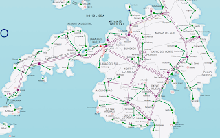
Maps of Mindanao Island, Philippines

Mindanao is a major island in Philippines and one of the three adiministrative regions of the country (the other two being Luzon and the Visayas). In terms of size it is second only to Luzon island. "The land of promise", as Mindanao is sometimes called, has an estimated population of 21,582,540, making it the second most populous island (compared to Luzon's approximately 45 million inhabitants and the Visayas' approximately 17 million.

The exact size of Mindanao island is 61,077 square kilometers, or 23,582 square miles.

Maps of Mindanao island in Philippines

Mindanao island map

Map of Mindanao Philippines island


Mindanao is a great place to visit if you keep aware of the political reality of the island. I hope the abovemaps of Mindanao assist you in your research and planning!

links for 2010-07-10


Google Maps Gets Short URL's


One of the most annoying things in Google Maps are the ridiculously long URL's you get when you click on the 'Link' option. These long URL's are particularly annoying if you wish to link to a location using Twitter. Until now if you wanted to share your location via Twitter you have been forced to run the Google Maps link through a URL shortening service.


Not any longer! Google Maps now has a short URL service. If you select the 'Short URL' option in Google Labs (the green bottle at the top of the map if you are logged into a Google account) you can now get short URL's for location links.

Once you have enabled the Short URL option whenever you click on the Google Maps 'Link' button you will be given a nice short URL instead of one those unfeasibly long ones.

Here's a link to the satellite image of the Eiffel Tower -http://goo.gl/maps/7nps

Google Maps Gets Short URL's


One of the most annoying things in Google Maps are the ridiculously long URL's you get when you click on the 'Link' option. These long URL's are particularly annoying if you wish to link to a location using Twitter. Until now if you wanted to share your location via Twitter you have been forced to run the Google Maps link through a URL shortening service.


Not any longer! Google Maps now has a short URL service. If you select the 'Short URL' option in Google Labs (the green bottle at the top of the map if you are logged into a Google account) you can now get short URL's for location links.

Once you have enabled the Short URL option whenever you click on the Google Maps 'Link' button you will be given a nice short URL instead of one those unfeasibly long ones.

Here's a link to the satellite image of the Eiffel Tower -http://goo.gl/maps/7nps