PinPoints
PinPoints is a clever short URL creator for locations, that will work with any mobile phone, no matter what mapping service it uses. PinPoints figures out what navigation software you have and will show the sent location on whatever map service you have available.
PinPoints allows an address, like "221B Baker Street, London" to be converted into something like http://directions.to/sherlockhomes. This URL can then be shared by email, SMS, Tweet etc. When someone then clicks on the link it will show the location on an online map. If you click on it via a BlackBerry device it will open in BlackBerry Maps, when you click on it via a Nokia smartphone it will open in Nokia Maps and for iPhone users it will open Google Maps and so on.
If you open a PinPoint created link in a browser you will be asked if you want to view the location in Google Maps or Bing Maps.
Wednesday, December 8, 2010
Street View imagery released in Romania
Google has just released Street View imagery in Romania, the first new release sinceGoogle Earth 6 came out last week.

As you know, Google Earth 6 completely changed the way that Street View imagery is handled. If you're not familiar with the changes, this video will show you how it works:
In addition, as pointed out by Google Earth Design, you can now include Street View when creating a tour in Google Earth! Rich even built a sample KML
It works just as you'd expect:
1. record a tour in the normal way,
2. drag and drop the pegman (orange man icon on the main screen controls) half way through to enter streetview
3. navigate around in streetview
4. click 'Exit Street View' button top left of your screen to exit street view
5. stop the tour.
He also includes a bit about the technical aspects of the KML that is generated:
GEarth 6 has spawned a new gx KML element: "gx:ViewerOptions", this element inserted into a FlyTo parent with"gx:option name="streetview"" tells GEarth to changes from normal to Streeview in the middle of a tour. ViewerOptions also allows historical imagery and sunlight conditions to be captured as well.
This certainly opens up a lot of possibilities for great new tours using Google Earth. Check out Rich's full article for more information, and let us know if you create any noteworthy tours using this new feature.
Google Maps Now with Vector Graphics
Google's Andy Rubin recently demoed at the Dive Into Mobile conference the soon to be released new version of Google Maps for Android.
The biggest change in Google Maps 5.0 for Android is that Google are dropping map tiles for vector graphics. The use of vector graphics will lead to two great improvements for Android mobile map users.
In the video above you can see the improvements that vector graphics provide in the display of 3d building outlines. The 3d buildings will have dynamic shading that update on the fly as you change the perspective of your view. The buildings also allow the maps to be rotated to orient to the direction your phone is facing and allow oblique views.
The new vector graphics will also give Google Maps much better caching capabilities. This should mean that Google Maps on your Android will work much better when you don't have a data connection.
Google Maps 5.0 is expected to be released in the next few days.
Google Maps Goes Above & Beyond
Trance Around the World with Above & Beyond
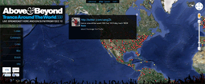
Above & Beyond's weekly 'Trance Around The World' radio show is syndicated on over 237 FM radio stations worldwide with a total estimated audience of 30 million. With such a wide range appeal it only seems natural to allow trance fans around the world to share their thoughts with this animated Google Map.
The map animates through the latest Twitter messages with the hashtags #tatw or #tatw350. The map also shows the locations of all of radio stations around the world that broadcast the show and the locations of upcoming trance events.
The map is also doing a very good job in promoting the TATW 350 event at the LA Palladium this Friday. There will be a seven hour broadcast of the event through local radio stations, Sirius XM and online via DI.FM and TATW350.com.
Via: All things spatial
Bing Maps Adds Malls

The preview lists a set of malls in the Seattle, Boston, and NY metro areas, including:
source:1. Bellevue Square, WA
2. Crossroads, WA
3. Redmond Town Center, WA
4. Shops at the Bravern, WA
5. Meridian Town Center, WA
6. North Bend Premium Outlets, WA
7. Seattle Premium Outlets, WA
8. Cascade Mall, WA
9. Everett Mall, WA
10. Kitsap Mall, WA
11. University Village, WA
12. Marketplace at Factoria, WA
13. Bellevue Place, WA
14. Lincoln Square, WA
15. North Gate Mall, WA
16. Pacific Place Mall, WA
17. Tacoma Mall, WA
18. West Field Southcenter Mall, WA
19. Southhill Mall, WA
20. Queens Center Mall, NY
21. Roosevelt Field Mall, NY
22. Chestnut Hill Mall, MA
http://www.bing.com/community/site_blogs/b/maps/archive/2010/12/07/bing-s-new-mall-maps-get-in-get-out-and-the-avoid-the-crowds.aspx
Real-Time Snow Ploughs on Google Maps
The City of Calgary - Road Conditions Map
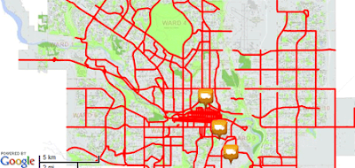
The City of Calgary are using the Google Maps API with custom map tiles to provide citizens with the latest road conditions in the city.
The map shows the priority routes in the city for snow ploughing and even shows the real-time locations of the city's snow ploughs. It is also possible to view the city's traffic cams so you can check for yourself that the roads have been ploughed.
The controls at the top of the map allow the user to zoom in and out and pan the map.
Hat-tip: Mapperz
Subscribe to:
Posts (Atom)