Tuesday, July 27, 2010

Afghanistan War Logs Mapped - Part two

Afghanistan War Logs: IED Attacks Map

The Guardian newspaper have created another informative Google Map from the WikiLeaks War Logs from Afghanistan. The Guardian's IED Attacks Map shows the location of 16,000 improvised explosive devices in Afghanistan over 5 years. The improvised explosive device (IED) is the Taliban's weapon of choice.

The map includes an animated timeline. If you press play at the bottom of the map you can watch the data being animated on the map from 2004 to 2009. It is even possible to view what data you wish to view on the map whilst it is being animated. The map includes markers for civilians, coalition troops, Afghan troops and others. You can select to view any combination of the map markers.

On Sunday The Guardian released the Afghanistan: The War Logs Map. The map geotags a selection of 300 of the key intelligence reports from the War Logs.

The Gulf Oil Spill Bird Tracker

eBird Gulf Spill Bird Tracker

eBird have created this Google Map to show bird sightings in the Gulf of Mexico. The map also displays an oil slick forecast for the next four days.

The oil slick forecast is provided by the National Oceanic and Atmospheric Administration. The bird observations are from eBird's own tens of thousands of users. The bird sightings on the map are indicated by red markers for sightings older than 30 days and yellow markers for more recent sightings.

You can change the bird species displayed on the map by clicking the 'more species' button and selecting one of the available bird species.

eBird Global Range Maps

eBird have also created this Google Map that displays a range map for any bird species around the world. There isn't any information available on how the map works but I assume the range maps are created by using the sightings for each species submitted by eBirds users.

To use the map you just need to enter the name of the bird species into the search box. The map will then display a heat map showing locations around the world where the species has been sighted.

Bird Observations
Finally, eBird also let you create a point map for any location, or a seasonal grid maps for the Americas for any bird species using Google Maps.

Other Birdwatching Maps

Google Places team answers questions via YouTube

When Google Places was reintroduced with its new name and additional features earlier this year, we thought it’d be an opportune time to experiment with a new way of engaging with our users. So we launched a Google Moderator page and invited business owners who use Google Places to ask and vote on questions and submit product ideas. Our team also committed to answering the top posts via video.

Many takes later, we’re excited to share eleven new videos that are now live on the Google Places YouTube Channel. While we’re aware that the film quality could be improved, we hope you enjoy putting faces to the names of our forum guides, seeing some of our team’s personalities reflected in the videos, and even getting to hear from a Google intern.

Video responses are a new method of interaction for us, so we’ll track viewership, business owners’ reactions and other factors to determine if this is a useful project we should continue. In the meantime, feel free to watch our most popular video to date about ranking from local product manager Jeremy Sussman, or any of our other video responses.


Happy viewing, and we hope these videos are helpful, informative and interesting for all you business owners using Google Places!

The Geospatial Revolution Project


The folks at Penn State Public Broadcasting are in the middle of creating a series of videos showing how geo-spatial technology is changing the world we live in.
They've released a five-minute video showing some of the content that will be in the series, and it's a great little video. Check it out:


According to their website, they have a list of problems that are aided heavily by geospatial information, such as:
  • fight climate change;
  • map populations across continents, countries, and communities;
  • track disease;
  • strengthen bonds between cultures;
  • defend the nation;
  • assist first responders in protecting safety;
  • enable democracy;
  • navigate our personal lives.
They plan to release the first episode in mid-September of this year, and we'll certainly be keeping an eye out for it. In the meantime, check out their site or follow them on Facebookor Twitter for the latest updates on the status of the project.

Guy Walks Across America - Google Map

The latest YouTube viral video is this amazing timelapse of someone walking across America.


The video is accompanied by a Google My Map of the route. The map includes behind the scene pictures and videos that were shot on the journey from Brooklyn Bridge to the Golden Gate Bridge.

TimeMap Berlin


This Bing Map lets you view historical maps of Berlin. The map features an innovative 'timescope' that you can drag over the modern map of Berlin whilst viewing the historical map through the timescope.

If you wish to view a different historical map of Berlin you can select a date from the bottom of the timescope. It is also possible to adjust the transparency of the historical map to view the modern map beneath. On the right hand side of the map are quick links to some of Berlin's top sights.

TimeMap Berlin

Finding a Health Clinic with Google Maps

Anthem Clinic Locator

Anthem Blue Cross in Virginia say that more than 60 percent of emergency-department visits by Anthem members are actually for non-emergency medical problems. ER wait times are at an all-time high, so patients with non-emergency problems can actually cause delays in doctors treating real emergencies.

To help their customers find medical care quickly when they can’t see their regular doctor Anthem Blue Cross have created a Google Map of health clinics, walk-in doctor offices and urgent care centers. They hope the map will help reduce the number of visits to ER by non-emergency patients.

The map allows Anthem customers to search by address or zipcode. Health clinics, walk-in doctor offices and urgent care centers are shown on the map by categorised map markers. The information window for each facility contains the full address, opening hours and an option to get driving directions.

London's Ping Pong Summer

Ping London

This summer the English Table Tennis Association have placed 100 ping-pong tables in London's squares, shopping centres, estates, offices and train stations. The campaign, named Ping, aims to get a million more people playing more sport by 2012.

So if you are in London and you fancy a game of outdoor table tennis then you should check out the Ping map. The Ping Google Map shows the location of all 100 table tennis tables.

The map sidebar has a nice feature that dynamically loads the nearest table tennis tables to the map centre as you pan the map. The listings in the sidebar also inform you how far the tables are from the current map centre.

Hat-tip: knowwhere

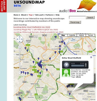
The UK SoundMap Beta - British Library


UK SoundMap starts with a pilot survey based on the Sheffield metropolitan area. The national survey will follow later in 2010. 
The UK SoundMap Beta - British Library


Make sure Location Services in Settings/General is switched on. Otherwise you can edit your recording on Audioboo FM and add a location by placing the microphone icon on the map at the place where you made the recording

How can I take part?

If you can make recordings in any location within the Sheffield area, please record your surroundings, describe them with tags and comments, then upload the recordings to our map. From there, a permanent public record of everyday sounds - the UK SoundMap - will be made accessible to everyone, while being stored at the British Library and made available to soundscape experts.

Want to add your sounds to the map then follow these steps;

  1. register with AudioBoo
  2. record & publish
  3. listen to soundscapes

Ways to record and publish

There are two ways. The easiest way is to use a smartphone.Alternatively you can use a web browser.

Listen to soundscapes

Once uploaded, your recordings will be found easily as locations on the soundmap and searchable by tags. Please allow 48 hours for your recordings to appear on UKSoundMap. You can meanwhile check your recordings right away on AudioBoo.fm

  • Just record your everyday surroundings.
  • What do your home, leisure and work environments sound like?


    • What sounds define these places and how do they make you feel? Some may be restful, some unpleasant - let us know why.
  • Does the sound of these places differ during the day?


    • What are the differences? Let us know what these sounds mean to you.
  • Where are the noisiest or quietest parts of your locality?


    • What makes it so noisy? What can be heard even when it's quiet?
  • Make as many recordings as you like at different locations and times.
  • Each recording may be up to 5 minutes long.
Map 
http://sounds.bl.uk/uksoundmap/map.aspx 

Source:
http://sounds.bl.uk/uksoundmap/index.aspx