Monday, August 23, 2010

The Hottest Events in Town on Google Maps

Hotlist

The Hotlist is a website that can show you the trending locations in your vicinity.

Hotlist uses Google Maps to show you upcoming events in your area and in your social network. The application shows you the venues that are generating the most buzz on social networks and can show you which events your friends are attending.

It is possible to connect to Hotlist with a Facebook account to see what your Facebook friends are up to. As of today Hotlist is also using the new Facebook Places API. This should ensure that you can now more easily find out what hot events your friends will be attending.

Via: Read Write Web

Google Mobile App for iPhone gets pushy

Ever missed an appointment or important email because you were away from your desk? Now Google Mobile App can help with push notifications from your Google account to your iPhone -- an icon badge shows you’ve got new mail in Gmail, and Google Calendar event reminders appear right on your home screen.


We’ve also added spiffy features to get you information faster -- when looking for flight info, weather, stock quotes or currency conversion you’ll see answers before you even hit ‘Search’.


You can get the update from the App Store by searching for ‘Google Mobile App’.

If you have any questions or comments, or if you want to learn more, please visit our help center.

The LA Times on Google Maps

The Los Angeles Times is becoming a prolific user of Google Maps. Here are just some examples of how the paper has used the Google Maps API to help illustrate news stories and give their readers access to local data.

Mapping L.A.'s Neighborhoods

The LA Times’ neighborhood map of Los Angeles County is a Google Maps interface to individual maps and statistics for 158 cities and unincorporated places and 114 neighborhoods within the city of Los Angeles.

The map allows readers to click on one of the highlighted regions on the map and then select an individual neighborhood. Once you have selected a neighborhood you can view information about schools, income, demographics and news from the area.

LA Magnet Test Scores

A Google Map created to compare the test scores of Los Angeles' magnet schools with other magnet schools and to their host schools.

L.A. Farmers Markets
A Google Map guide to Southern California farmers markets. It is possible to browse the markets by location and by the day of the week.

Where the Westside Starts
The Westside has no official defined border. Therefore the LA Times decided to ask its readers how they define the Westside.

The Times then produced two Google Maps; one to show The Times' definition of the Westside's geographical boundary and one to show the readers' ideas.

DOAG SIG Spatial 14.9. in Frankfurt-Dreieich

Eine jedes Jahr immer wieder sehr intereassante Veranstaltung findet am 14. September in Frankfurt statt: Die DOAG SIG SPATIAL.
Man kann den Event sogar noch um einen Tag verlängern zum "Hands-On" mit APEX und Oracle Maps.
Anmelden bitte über die DOAG Seiten.

Important Basics for Google Earth

[IMPORTANT NOTE: this post was initially written for Google Earth versions 4.0 through 4.2, but has been updated with tips covering Google Earth 5.2. For more info, you can read tips on navigating from the GE User Guide.]
Mount St. Helens in Google EarthIf you are new to Google Earth (GE), or looking for ways to improve how you interact with GE, then this entry may be of help. Additional resources are referenced below. Note: this blog entry assumes you are using Google Earth 5 or higher. For tips on Google Earth 4, you can view the Google Earth 4 user guide.
Learning to manipulate the mouse and keys to control GE is crucial to getting the most out of sightseeing the Earth. The first important thing to know is how to zoom in closer to the Earth. You have many ways to do this: double-clickyour mouse button (left button, if you have multiple buttons, to zoom in, right button to zoom out); use the mouse scroll-wheel (if you have one); use the + and - keys; or use the PAGE UP or PAGE DOWN keys to zoom more quickly. You can also use the navigation gadgets - the "+" and "-" buttons with slider on the far upper-right to change your altitude. The mouse scroll-wheel is probably the favorite method of most typical GE fans. All of these methods adjust your altitude above the Earth's surface. You can see your height above sea level in the lower right of the GE viewing window. You can move the Earth to position it where you want to see by clicking a point with the left mouse button and slide the cursor to the middle of the viewing window.
At first, many people don't realize Google Earth is much more than a map with aerial and satellite photos attached. GE uses data from NASA Space Shuttle missions which provides 3D terrain data for the entire land surface of the Earth. Let's demonstrate this.
Click on this link  to go to GE and fly to Mount St. Helens. Beautiful view right? But, try this: hold your SHIFT-DOWN key combination and watch GE tilt your view so you can see Mount St. Helens as a 3D mountain (if you don't - check to see that the "Terrain" layer is turned on). Very cool right? SHIFT-UP will tilt your view back up. You can also use the slider control at the upper right of the navigation control for tilting. A nice tip: hit the "u" key to tilt back straight up automatically. The "r" key will reset to north and tilt up.
An easier way to tilt and pan your view is to click and hold the middle mouse button or scroll wheel button (those of you who have a Mac with one mouse button have to use the above key or navigational control techniques - but, I would recommend getting a 3-button mouse). While you're holding the middle button if you move your mouse forward and backwards it will tilt the view. Side to side will pan your view around the point you are looking at.
While some of the tips no longer apply, this short 2 minute video tutorial from Google can help cover some of these navigation basics.
Related Resources:

MILF Location Finder

Gowalla MILF

I'm guessing the acronym used in the name of this application is entirely intentional and will probably ensure it gets a few more page hits than it might otherwise have done (it certainly caught my eye). In this case, however, MILF stands for 'Missing Items Location Finder' and not what you might have first thought.

The application uses Google Maps to help you locate Gowalla spots near you which contain items which are missing from your vault. To use Gowalla MILF you just need to log-in with your Gowalla account. Once logged in just double click anywhere on the map to scan that area for your missing items.

Via: Digital Urban

Irish Mileage Calculator uses Google Maps

MileageSheet

Least week I posted about Tripcatcher a Google Maps based mileage logger for the UK. MileageSheet provides a very similar service for Ireland.

MileageSheet allows you to manage mileage rates, subsistence rates and expenses. The application allows the user to create routes and record journeys. It can then calculate distances and work out the mileage expenses.

MileageSheet can record employee information that is required by the Irish Revenue Commissioners and keep track of their expenses. It can also review employees' mileage sheets and the amounts payable according to their assigned schemes.

Spatial Data Viewer on Bing Maps App

View
  • ESRI Shapefiles (.shp & .dbf files) [best under 300k]
  • GeoRSS Feeds (.xml with lat & lng)
  • Well Know Text (WKT)
Known as Ricky's Data Viewer
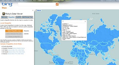
Bing Maps Shapefile Viewer
Loaded Shapefile (World Countries) in the Data Viewer using 'select shapefile' option, .dbf if your want to see attributes (table data).

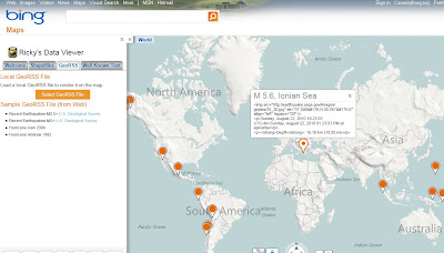
Bing Maps Viewing GeoRSS Feeds
GeoRSS (.xml) recent earthquakes feed from (USGS)

Full list of Bing Maps Apps.