So rather than wait, we decided to launch biking directions in “beta” and ask our community of bicycle-bound users for their help improving our bike maps. Through our “Report a problem” tool, any user can send us corrections or recommend improvements, and receive notifications from Google when their report has been resolved. We always knew the cycling community would be a passionate bunch, but the response to both our biking directions feature and our call to join in the effort to improve our bike maps has surpassed our happiest expectations.
More than 10,000 people have submitted about 25,000 suggestions for improvements to our bike maps. With their help, we’ve added bike lane and trail data for an additional 80 cities since our initial launch. This is an exciting and humbling response from the Google Maps community. It’s like having 10,000 new members of our bike maps team, contributing their time and energy to make Google Maps more useful for everyone.
These contributors have impacted biking directions across the nation - in small and large ways. Here are some examples of suggestions we’ve received:
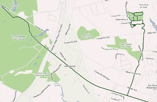
- One user simply pointed out to us, “Wall Township Bike path - http://www.wallrec.com/bicycling.htm.” Our response to that short and sweet message?Here it is:

- Some else sent a note saying, “CSUS - there has been a bike/foot traffic tunnel that connects elvas ave to College town dr for about 6 years. it is located between 64 & 65 st.” Well, that’s handy to know! Done:

- And yet another user shared, “Cycle/hiking path continues to the East across Switzer and connects with the path that is currently shown on google maps ~2.5 miles to the ENE at 130th and Metcalf Ave. Details on Overland Park website http://www.opkansas.org/Resource_/PageResource/Maps-And-Stats/Maps/Adobe-Acrobat-PDF-Maps/bike_route_plan.pdf Thanks.” Awesome! Overland Park is nowlooking pretty good for cyclists:

This is how we’ll build a great cycling map: Bit by bit, getting better with every tip and suggestion that users share about the lanes and trails they’ve ridden.
We want to say “Thank you!” to all those who’ve answered our call for bike map contributions. Clearly our users are passionate about helping to make our maps better, so we’re working hard to make the improvement process even easier and to speed up the processing time for user contributions.
In the meantime, happy biking! Just remember that our biking directions are still in beta, and to always use your judgement - don’t ride down any road that makes you uncomfortable. And if we’ve recommended a road that shouldn’t be used by the average bicyclist, let us know!
No comments:
Post a Comment