Thursday, April 14, 2011

Find a Parking Spot with Google Maps


Parking in Motion


Parking In Motion’s free iPhone app lets you find, reserve, and pay for parking spots across the US, Canada and Europe and also gives the driver occupancy information in certain locations in real time.

The app has coverage of the US, Canada and Europe with over 20,000 public parking lots enhanced with rates, hours, entrance points, and occupancy information. Using the app it is possible to view on a Google Map all the parking facilities for a location.

Markers on the map show the current occupancy rates at the different parking facilities shown. If you click on a marker you can view details about prices, the opening hours and its phone number.

The app is currently available for the iPhone and Android and Blackberry apps are also in the pipeline. 

Thursday, April 7, 2011

California School Funding on Google Maps

California School District Funding

This Google Map shows school district funding in California. Using the map it is possible to view funding levels in each district and also view the school district's academic performance.

If you click on a school district you can view details of the funding over the last three years together with a projection of the funding next year assuming there is no tax extension in California.

The map also displays State Senate districts. If you click on a Senate district you can view the name and party affiliation of the district Senator and their winning margin.

U.S. Cultural Landmarks on Google Maps

CultureNow

This Google Map is mapping the locations of history, art and architecture in the public realm. The project was started in New York, and has mapped a huge number of cultural locations in the city, but now also shows cultural landmarks across the USA.

It is possible to search the map by category (and there are a lot of them). So, for example, it is possible to refine a search for art galleries, museums or historic buildings etc. If you click on a map marker you can get more information about the listing.

Each listing also includes a list of other nearby cultural locations.

Mapping Nuclear Plants & Earthquake Data

The World's Nuclear Power Reactors

This German Google Map shows the locations of the world's nuclear power plants. It also shows the locations of all the power plants currently under construction, those that are suspended and those that have been shut down.

The map shows that Japan currently has plans to build another nuclear plant on its east coast at Ōma. I wonder if it will ever be completed.

The map also contains two layers that let you view world earthquake data (with a magnitude of 5 or greater) for the last twenty years.

Nuclear Power Plants and Earthquakes Map

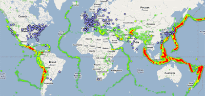
I've always wondered about the advisability of building nuclear power plants on top of fault lines. This Google Map shows global earthquake activity since 1973 and the locations of nuclear power plants around the world.

The map displays a heat map of 75,000 4.5+ magnitude earthquakes since 1973 based on data from the United States Geological Survey. I'm no expert but the map does make me question even more the advisability of building nuclear power stations in places such as Japan and California.

Where's This Picture From on Google Maps


Where the F##k is This?

This imaginatively named website allows you to ask the crowd where a photograph was taken.

If you have a picture and you are unsure of the location depicted you can upload it to Where the F##k is This and, if you are lucky, someone will know and show you its location on a Google Map.

Each picture is displayed with a Google Map. If you know the location depicted you can click on a Google Map to show the exact location and leave a comment.

The website includes a What's Hot section and a section for pictures that have already been located.The Lincoln Lawyer: A Novel

What's Going On with Google Maps

Map Channels Events

MLB All Star Game - Tuesday, 12 July 2011

Map Channels Events is a Google Maps based music and sporting events website with tens of thousands of events displayed at thousands of venues around the world. Using the website's interactive event calendar and Google Maps it is possible to find and buy tickets for all kinds of sporting, musical and theatrical events.

Map Channels Events has just added interactive floor-plan maps, supplied by Seatics, for many of its listed venues. The floor-plan maps allow customers to quickly compare prices in different sections of a stadium and see what kind of seating they are buying.

As well as the interactive floor-plans Map Channels Events includes a Google Map and Street View for each listed venue.

2012 Olympics on Google Maps

London Olympics Site

Today it has been gloriously sunny in London, so this afternoon I decided to take a stroll to the site of the 2012 London Olympics. I had my phone with me so I took a few photographs on my walk.

After uploading the photos to Picassa obviously the first thing that I thought of was to create a Google Map. There is nothing overly exciting about this map but I thought there might be some interest in having a look at the site of next year's London Olympics.

The satellite imagery on Google Maps for the Olympics Park was updated last month - so that's another reason to have looksie.

Tuesday, April 5, 2011

Historical UK Maps API

National Library of Scotland Maps API

The National Library of Scotland has released an API to give developers access to a map of the UK using out of copyright Ordnance Survey maps, dating from the 1920s to the 1940s.

The API uses Google Maps to create an interactive map based on tiles created from the Ordnance Survey Maps. You can see the basic map here. This map can be embedded into other websites and blogs just by copying and pasting the iframe code. You can even embed a map using a dynamic URL so that the embedded map is zoomed and centred on your chosen location.

However you can also use the API to create your own mashups. For examplehere is a map that has an added transparency slider, that allows you to view the Google Map tiles beneath the OS maps. 

Americas Rock on Twitter

Twitter Top 100 Users

This Google Map of the Top 100 Twitter users (based on the number of followers) reveals that only 7 of them live outside of the Americas. Those 7, who are all based in Europe, even include Brazilian footballer Kaka and U.S. tennis player Serena Williams.

The markers on the map are colour-coded by category, for example, music, entertainment, technology etc. Like BatchGeo's Map of Top 100 Websites Worldwide the map features a really cool marker clustering system. Not only does each clustered marker show the number of markers at the location it features a nice pie chart that represents the percentage of each website category at the location.

Keep on Running with Google Maps

iFit 

With the iFit you can now run anywhere in the world, virtually, with a little help from Google Maps and Street View.

You can connect iFit Live to an iFit treadmill or exercise bike. You then have the power of Google Maps to create a route anywhere that you fancy running. When you run on your iFit treadmill you can then follow your progress on your route with Google Maps and with Street View, where available.

You can get a good idea of what the experience is like by visiting the iFit demo page. With this demo feature you can draw and view workout maps. You can plan a route and even follow it in Street View.