Friday, March 25, 2011

Lights Out for the Sky at Night

GLOBE at Night Webapp

The GLOBE at Night organisation are endorsing the Earth Hour event on March 26 and would also like you to help them gather data as part of their research into light pollution.

To take part in the research you simply need to check the night sky and see if you can identify the constellation Leo or Crux. To help you find the constellations GLOBE at Night have provided a Google Map to determine your location and present you with several magnitude charts of the night sky.

All you need to do is determine which of the magnitude charts of the sky most resembles what you see and complete a short form.

Real-Time Instagram on Google Maps

Mapstagram

Mapstagram is a super-fast real-time Google Map of photos taken with the Instagram iPhone app.

When the Mapstagram map first loads it displays the most recent photos from a number of U.S. cities. After the initial photos have loaded Mapstagram goes into real-time mode. As photos are uploaded by users in these cities, they are immediately displayed on the map in real time.

Gramfeed

Gramfeed uses the Instagram API to present the best photos from Instagram on Google Maps. It also allows users to view their own photos, a time-line of those they follow, read comments on photos and Tweet about photos and much, much more.

Tuesday, March 22, 2011

Social Network - The Google Map

Xuland

Xuland is a Google Maps based social network that lets you share comments, pictures and links with those around you and search for venues, events and deals around your location.

Using Xuland you can comment on any location. If you like the comments of other Xuland users you can choose to 'follow' them. Xuland also has plans to offer comment badges soon to reward you for adding your thoughts.

You can also view nearby venues from Yelp, view deals for local venues from third party sites such as Groupon, and search for local events from Eventful. 

How Manhattan Grew on Google Maps

How Manhattan’s Grid Grew

In 1811, John Randel created a proposed street grid of Manhattan. The New York Times has created a Google Map that allows you to compare Randel's map to modern-day Manhattan.

The map also includes an 1836 map of the farms of Manhattan, a map of street openings since 1642 and historic census data. Each of the maps is supplemented by a transparency slider that allows you to view the modern map underneath.

The map of street openings since 1642 allows you to visualise the growth of Manhattan. If you use the time-line control you can watch the spread of Mahattan from just a few streets to the present urban sprawl.

Radiation Levels Mapped - Updated

Japan Radiation Maximum by Prefecture

The UN nuclear watchdog, the IAEA, warned today that the situation remains 'very serious' at the Fukushima nuclear power plant. Many Japanese citizens are therefore obviously worried about radiation levels.

This TargetMap creation uses Google Maps to show the real-time radiation levels by prefecture. The data comes from the the System for Prediction of Environment Emergency Dose Information(SPEEDI). The results shown are the maximum values recorded in the latest update.

RDTN.org Japanese Radiation Levels

RTDN have created a Google Map of radiation level readings in Japan with data from Pachube and Marian Steinbach.

Each marker on the map displays the radiation level and the time of the reading. RTDN are also looking for people to submit their own accurate readings to the map, which you can do via a short form.


To provide context for these map you should also check out O'Reilly Radar'sOpen Street Map visualisations of radiation levels in Japan. The O'Reilly maps compare two days of recent radiation data with the normal radiation levels in Japan.

Saturday, March 19, 2011

Friday Fun with Google Maps

 Limerick Crime Map


There was an Old Person of Cromer,
Who stood on one leg to read Homer;
When he found he grew stiff, he jumped over the cliff,
Which concluded that Person of Cromer.

The classic limericks of Edward Lear are full of appalling incidents (and even more appalling rhymes). Staircase3 has therefore decided that it is only fit to present his limerick's in the form of a crime map.

The limericks are marked on this Google Map by the given location of each main culprit.

Postcards from Google Earth: Bridges


Artist Clement Valla has created a series of postcards created from satellite images of bridges captured from Google Earth. The strange distortion of the bridges in the images does create some interesting and surreal views.

Drag & Drop Street View

This little Street View application lets you find the Street View for any location in the world and drag & drop images to create your own montage. The images available mainly consist of cartoon cars and women.

Friday, March 18, 2011

The Universe in Motion

 Google Sky & Chromeless Videos

We don't nearly see enough maps created with the amazing Google Sky. Here is my latest effort, and it's pretty impressive, even if I do say so myself.

This Sky Map overlays a number of celestial animations on top of Google Sky. I've used the YouTube API to show the videos in a chromeless player. The effect is pretty cool, creating an almost seamless overlay of the video on the map.

________________
Labels: 

45° Imagery Added to Google Maps API 3

Google's oblique aerial view imagery has now been added by default to maps created with the Google Maps API. When 45° imagery is available a submenu option is added to the Maps API Satellite button. In three weeks time aerial view, where available, will automatically become the default satellite view, as it is in the main Google Maps website.


You can see the cities where 45° imagery is currently available on this map.

In addition to the new 45° imagery an Overview Map Control is being added to maps created with the Google Maps API v3. This Overview Map Control is the small interactive thumbnail map you can see on the bottom right of Google Maps.

The addition of the Overview Map Control is the latest in some nice subtle changes Google have added to the design of Google Maps created with the API. Recently Google also changed the Google logo in API maps to a white logo instead of the usual multi-coloured logo and the buttons have also been made a lot more attractive.


Via: Google Geo Developers Blog

Brazilian Sports Facilities on Google Maps

Gatorade Maps

Here's a nice idea from the sports drink Gatorade. The company have created a useful Google Map to help Brazilian's find their nearest sports facilities. 

Using the map it is possible to find the nearest gyms, sports centres, walks and bike routes around a location. You can filter the results by location and by the type of sporting activity you are interested in.

To promote Gatorade the map also displays the nearest retail outlets that sell the sports drink.

Thursday, March 17, 2011

Wikipedia Chloropeth on Google Maps

Ragtag Map of Wikipedia Articles

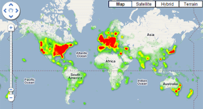
The Ragtag blog has created a Google Map of every Wikipedia page tagged with a latitude and longitude. 424,171 articles in Wikipedia have been geotagged. You can see the geographical distribution of the articles in the heat map above.

Ragtag were also able to find 14,238 historical events that were geotagged on Wikipedia. By plotting the events by year and location Ragtag have managed to create a dynamic visualisation that gives a rough idea of the history of the world in 100 seconds.