Japan Quake Map
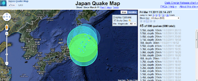
Paul Nicholls, the developer of the Christchurch Quake Map, has created an animated visualisation of all the Japanese earthquakes since March 11th.
The Google Map shows the magnitude and depth of each recorded quake. The size of the displayed polygons reflects the magnitude of each individual earthquake and its colour reflects the depth.
You can pause and resume the animation. A drop down menu also allows you to select to view the data for a specific day.
Worldwide Penis Size Map
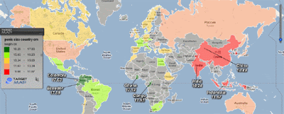
According to this Google Map the men of Congo are the proud owners of the world's largest tadgers. If you want to know which men have the smallest peckers then you need to grab your magnifying glass and visit this user created Target Map.
A choropleth overlay gives you a quick overview of the world's willies. You can also click on individual countries to view the size of Bavarian beefsticks, Canadian cattle prods, Spanish salamis or Russian ramrods.
That's it, I'm out of euphemisms ...
FIND
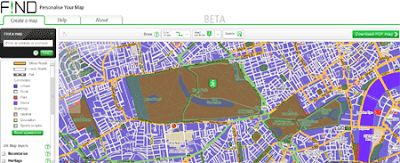
FIND is the first Google Maps creation tool I've seen that allows the user to customise their created map using the Google Maps API Styled Maps functions.
Using FIND it is possible to add map markers, polylines, polygons, text and data from a number of sources to a Google Map. You can the style your map, changing the colours of all the map features to suit your preferences and then save your map to PDF.
The information that can be added to the map includes data from English and Scottish Heritage, the British Geological Survey, Natural England and the RSPB. Maps can be annotated with shapes, text, symbols and measuring tools and then saved to PDF in a neat print template.
A really nice feature of the tool is the ability to customise a Google Map through the 'Your Google Map' option. This feature utilises the Google Maps API Styled Maps functions. The 'Your Google Map' option allows users to change the colour of every feature on their Google Map to suit their specific requirements and preferences.
Nuclear Power Plants and Earthquakes Map
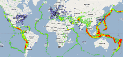
I've always wondered about the advisability of building nuclear power plants on top of fault lines.This Google Map shows global earthquake activity since 1973 and the locations of nuclear power plants around the world.
The map displays a heat map of 75,000 4.5+ magnitude earthquakes since 1973 based on data from the United States Geological Survey. I'm no expert but the map does make me question even more the advisability of building nuclear power stations in places such as Japan and California.
The Canadian Tourism Commission and their creative agency DDB Canada are using Google Maps Street View in an online advertising campaign. The online ads use Street View to promote Canadian cities and tourist attractions.

You can view an example of one of the ads in this mock-up of The Guardian website. The ad in the example zooms in on Montreal on Google Maps before opening up a fully interactive Street View of Rue Bonsecours.
Each online ad ends by directing users to additional location-specific information on the Keep Exploring campaign site where they can further explore what each destination has to offer.
The campaign is currently running in Germany, France and the UK.
Google College Basketball Tournament Map
Google has created a Google Map of the 14 arenas used for the 2011 NCAA Basketball Championship. The map includes all the schools involved, the schedules and the venues.
Also included is a distance tool so you can measure how far each school has to travel. There is even an option to switch on the Google Earth browser and view all 14 arenas in 3D.
If that isn't enough for you the map also contains a little game that lets you shoot some hoops yourself.

Via: Official Google Blog
100 Years of Set Locations

Do you ever wonder what films have been shot in your neighborhood? Well, with BoxOfficeQuant's new Google Map you can find all the movies that have been shot on location near your home.
The map displays the top 2,000 films from 1910-2010 according to IMDB. The location of sets used in each film was also obtained from IMDB. In total the map shows 9,736 locations from the 2,000 films.
The map uses Google Fusion Tables. It is a shame that BoxOfficeQuant didn't add the heat map option provided by Fusion Tables as it would be quite interesting to view the world's hot-spots for movie sets.
BoxOfficeQuant were even kind enough to respond to my wish to view a heat map of the locations used in the films.
Forbes Board
The Mapize team has created a nice visualisation of the Forbes Rich List.

As you can see the visualisation includes a fully interactive Google Map showing the location of the world's billionaires. You can filter the map to show the richest and the 'poorest' billionaires.


