Tuesday, October 12, 2010

Gun Ownership Data on Google Maps

Concealed Handguns in San Antonio: 2009

The Texas Tribune have analyzed a Department of Public Safety database that tracks concealed handgun licenses in Texas. The Tribune have produced a number of Google Maps to show the rates of gun permit ownership and income levels for each county.

My SA News has used the maps and the underlying data to look at how gun permit ownership is tied to income and politics. Overall the My SA News seems to conclude that gun permit ownership is lower in lower income areas because people can't afford the permits rather than that they don't own guns

Monday, October 11, 2010

California History on Google Maps

Calisphere

The University of California have created Calisphere as a gateway to more than 150,000 digitized items. These digitized primary sources include photographs, documents, newspaper pages, political cartoons, works of art, diaries, transcribed oral histories, advertising, and other unique cultural artifacts that reveal the diverse history and culture of California.

As part of the Calisphere project a number of Google Maps have been created to showcase some of the digitized historical photographs in the collection. Five maps have been produced to display the photographs by category. The categories are; transportation, city scenes, civic buildings, disasters andeveryday life.

Each of the maps displays the location of the photograph with a small thumbnail image. If you click on the thumbnail you can view the image in an information window and click through to get more information about the image.

Tagging Ghosts with Google Maps

Ghostag

When I saw the name of this Google Maps application I hoped that the creators had managed to attach GPS devices to a number of ghosts and were tracking their movements in real-time. No such luck. Ghostag is instead a crowd-sourced map of ghost sightings.

To tag a ghost on the map you simply need to click on a location and add the details of your sighting. If you manage to get a picture of the ghost (or failing that - the location of the sighting) you can also add that to the map.

The map uses the Google Maps API v3 Styled Maps function to create a suitably creepy look. When viewing the map turn on your speakers as it also contains some ghostly sounds and the occasional ghost like apparition appearing on top of the map.

Woooooo!

Sunday, October 10, 2010

Imagery of the Hungarian sludge spill

Hot off the satellite, we’ve received brand new Ikonos imagery of the recent sludge spill in Hungary. See the below screen shots for before/after images; you can also view the the imagery in Google Earth using this KML overlay. Special thanks to GeoEye for making updated imagery available so quickly.

Image credit: DigitalGlobe (left) and GeoEye (right)


Image credit: DigitalGlobe (left) and GeoEye (right)


Image credit: DigitalGlobe (left) and GeoEye (right)

Imagery of the Hungarian sludge spill

Hot off the satellite, we’ve received brand new Ikonos imagery of the recent sludge spill in Hungary. See the below screen shots for before/after images; you can also view the the imagery in Google Earth using this KML overlay. Special thanks to GeoEye for making updated imagery available so quickly.

Image credit: DigitalGlobe (left) and GeoEye (right)


Image credit: DigitalGlobe (left) and GeoEye (right)


Image credit: DigitalGlobe (left) and GeoEye (right)

The Chicago Marathon 2010 Route

Going the Distance - The Wall Street Journal

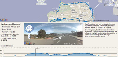
The Wall Street Journal's Going the Distance Marathon comparison tool has the route of this Sunday's Chicago Marathon. The map includes the Chicago Marathon route, an elevations chart and Street Views of the route.

The Wall Street Journal Going the Distance application also has Google Maps of the Boston Marathon route, the New York Marathon and the San Francisco Marathon. Each route is accompanied by an elevation chart and Street View.

My favourite feature of the Wall Street Journals maps is the superb integration between the elevation chart and Street View. If you hover your mouse along the elevation chart the Street View will update to show the respective view. Very cool.

Saturday, October 9, 2010

HubPages Get Google Maps

HubPages - Marks the Spot

HubPages is a self-publishing platform that lets anybody write about what they know and earn money from their original and topical content.

HubPages has added the option to embed a Google Map into a Hub page. HubPage members can now add points of interest to a map that are relevant to their Hub page. Each map gives readers the option to view additional walking, biking, or driving directions and, depending on the location mapped, readers can also view locations with Google Street View.

To launch the new 'map capsule' last month HubPages ran a competition for their members called 'HubPages Marks the Spot'. For the competition Hub pages had to be created that shared local information using HubPages’ new map capsule. 

The Grand Prize Winner of the competition was this HubPage on Where to buy Limoges Porcelain in Limousin, France. This Hub page includes a number of Google Maps, each being used to show the location of porcelain factories and shops in Limousin.

Friday, October 8, 2010

Styled Maps Overview

Styled Maps Using Google Maps API Version 3

41Latitude has produced some great examples of the map styles that you can create in Google Maps with the new Styled Maps feature. Each of the examples is accompanied by some suggestions of how the styles could be used and the JSON code that you can use to create the style.

The styles created include 'Buildings' (example in the pic above), 'Inverted Maps', 'Grayscale' and many, many more. If you are looking to customise the look of your created maps this is a great place to get some inspiration (and the JSON code).

If you want some more ideas about how to customise your maps then the Google Geo-Developers Blog post Five Great Styled Maps Examplesis also a great resource. The article includes seven (not five!) Google Maps applications that use Styled Maps to create an individual look. Here are the seven websites:

London at Night
 

Athens Taxi Cost Calculator 


Google 2010 Election Ratings Map 


Ubilabs’ Tour de France live tracker


Aquila Shoes Store Locator 


Maps Without Maps 


Team Coco Blimp Tracker 

Friday Fun with Google Maps

Pegman takes a Break

Pegman has been caught on camera taking a break after his recent exertions in Ireland, Brazil and Antarctica. If you look at the bottom of his to do list on the white board you can see that Middle Earth is next to get the Street View treatment.

Make Your Own Pegman

Google in Brazil have created PDF templates for you to create your very own Pegman. All you need to do is print out the template, cut Pegman out and stick him together.

How to Cheat in Mazes

Switched has a nice story this week about people trying to cheat in the hedge maze at Longleat Safari Park in the UK.

It normally takes visitors about 90 minutes to work their way out of the maze but the workers recently noticed that some people were flying through the maze in just a few minutes. It turns out that some visitors have been viewing the maze on Google Maps satellite view on their smartphones and using GPS to navigate through their way to the exit.

Thursday, October 7, 2010

Virtually travel the Northeastern U.S.


The Google Earth and Maps Imagery team has just finished pushing out a new set of images for you to explore and enjoy. Fall - when the weather isn’t too hot or too cold - is typically a beautiful season in the the American Northeast, and we’ve made some timely updates in the Poconos and Connecticut to help you see the places you might be planning to visit. For all you folks heading to Washington, D.C. for this month’s Rally to Restore Sanity and the March to Keep Fear Alive, we also recently updated our imagery of the D.C. metro area. Check out the all the sites, prepare for you trip, and don’t forget that you can find metro stops from yourGoogle Maps for mobile app!


Jim Thorpe, Pennsylvania

Washington, D.C.

High Resolution Aerial Updates:
USA: Allentown (PA), Bridgeport (CT), Stamford (CT), Camden County (NC), Washington DC
French Polynesia: Manihi

Countries receiving High Resolution Satellite Updates:
Mexico, Cuba, Guatemala, Honduras, Nicaragua, Costa Rica, Panama, Colombia, Venezuela, Ecuador, Peru, Brazil, Bolivia, Paraguay, Uruguay, Argentina, Chile, Poland, Hungary, Slovenia, Croatia, Austria, Serbia, Albania, Montenegro, Macedonia, Bulgaria, Greece, Russia, Turkey, Morocco, Algeria, Tunisia, Libya, Egypt, Mauritania, Senegal, Guinea, Sierra Leone, Liberia, Mali, Ivory Coast, Burkina Faso, Ghana, Benin, Niger, Nigeria, Cameroon, Chad, Central African Republic, Sudan, Eritrea, Ethiopia, Somalia, Kenya, Uganda, Tanzania, Rwanda, Burundi, Democratic Republic of the Congo, Congo, Angola, Zambia, Malawi, Mozambique, Botswana, Namibia, South Africa, Madagascar, Lesotho, Saudi Arabia, United Arab Emirates, Qatar, Jordan, Israel, Syria, Iran, Uzbekistan, Turkmenistan, Pakistan, India, Nepal, China, Myanmar, Thailand, Cambodia, Vietnam, Indonesia, Philippines, Korea, Mongolia, Australia, New Zealand

Countries receiving Medium Resolution Satellite Updates:
Cuba, China, India

These updates are currently only available in Google Earth, but they'll also be in Google Maps soon. To get a complete picture of where we updated imagery, download this KML for viewing in Google Earth.