Thursday, October 7, 2010

A Google Maps Lottery

GeoSweep

Every couple of months or so I get an e-mail from someone who has come up with the bright idea of setting up a Google Maps application that lets people pay them to own virtual real-estate on their created map. For some reason I'm not overly keen to promote these get-rich-quick schemes on this blog.

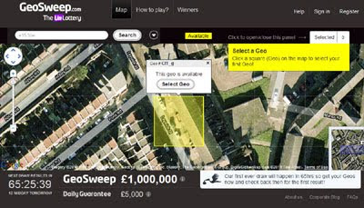
When I first heard about GeoSweep a few weeks ago I have to admit that I was a little dubious about the idea of holding a lottery using locations selected from a Google Map. GeoSweep is a UK nationwide game that involves users buying locations with a 10p stake. These plots are then entered into two daily draws, the first pays out a guaranteed minimum prize pot of £5,000 and the second gives players the chance to win £1 million.

Some of my concerns about GeoSweep have been assuaged by the success this start-up has had in attracting investment. GeoSweep has so far managed to raise over £2 million in investment and have put together a team of 15 who are now working out of their offices in London.

Worldwide Store Locator for Google Maps

Store-Locator.com

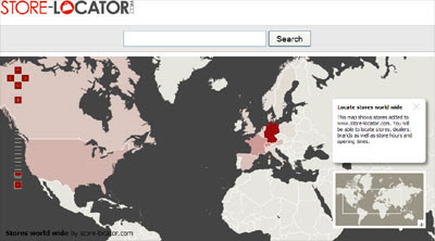
Shopping just got a whole lot easier with Store-Locator.com. Using Store-Locator.com you can find and locate stores worldwide and view information about individual stores including store hours and opening times. Store-Locator.com has mapped nearly 150,000 stores worldwide and are adding around 50,000 stores to their growing database every month.

From the Store-Locator.com home page you can navigate to a dedicated Google Map showing stores in individual cites or for specific store chains. For example, if you select New York you can view the locations of stores in New York on a single map.

If you select a marker on a Store-Locator.com map and click on the 'store hours' link you are taken to the store's individual entry. Here you can view opening hours, the store's address, contact information, website address and view the brands, products and services provided.

Excellent 3D model of a church in Russia

Located 250 miles east of Moscow in the city of Nizhny Novgorod, the Church of the Nativity of Our Lady is a remarkably beautiful structure. SketchUp user Semenov Nikolay has built a 3D model of the church and it's amazingly well done.
nativity-church.jpg
Along with the impressive architecture and texturing, Semenov also built up the terrain around the building to make it more accurate. All in all, it was very well done.
The model is not yet in the Google Earth 3D Buildings layer, but you can get it from the Google 3D WarehouseInfo | KMZ
We often like to showcase excellent 3D models like this on the site (such as Andy Dell andPeter Olsen's work), so if you've created a noteworthy model or a great collection of them, please contact us so we can check it out. Thanks!

Track Conan in New York with Google Maps

The Conan Blimp Live Tracking Map

To promote Conan O'Brien's new show 'Conan' TBS are flying a bright orange blimp over the east coast for the whole of October. You can track the blimp in real-time using the Blimp Map.

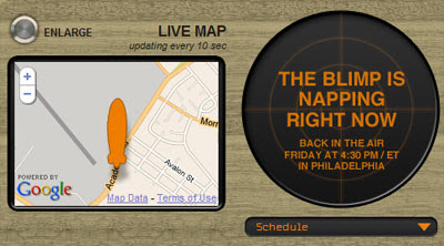
The Blimp Map uses Google Maps to show the real-time location of the Conan Blimp. The map updates every ten seconds to give a very accurate reading of the blimp's location. Alongside the real-time map you can view a live cam from the blimp. 

Currently the blimp seems to be taking a little break but it will be back in the air tomorrow in the skies over New York. 

Share Your Travels with the World

Travellerspoint Trip Maps

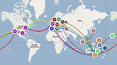
Travellerspoint is an attractive and easy to use application for creating a map of your travels. Using Travellerspoint you can quickly create a Google Map to showcase a trip that you are planning or have made. The application can also be used to show all of your trips on one attractive map.

Using Travellerspoint you can quickly create a trip map, simply entering your destinations. Travellerspoint will then create a map of your trip and automatically provide background information about each of the destinations on your journey from travellerspoint's own wiki travel guide.

If you want to plot separate journeys on one map you can do that. Separate colours are used for each trip and the user can control which colour each trip gets. You can add information about each stop and you can add photographs from your trip. You can even control the curve of each trip line.

You can embed your finished map on external sites and you can share the map with your Facebook friends.

Travellerspoint currently has over 1,000,000 trip stops mapped in its system. 

Google Latitude Just Got Interesting

Google Latitude

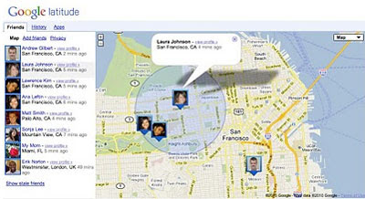
Google have revamped Google Latitude for the browser and added some very nice new features. Now you can view where your friends are and share your location from your desktop. You can also visualise your location history in some pretty cool ways.

Previously you have been able to use Google Latitude from your desktop via an iGoogle application but the new Google Latitude lets you view your friends current location on a large Google Map and also lets you view stats based on your location history.

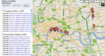
The map shows your current location and the last check-ins of your Latitude friends. The history stats includes a breakdown of the number of hours you have spent at home, work and out and about. It shows you a map of all the countries you have visited and it lets you view an animation of your check-ins to Latitude for any defined time period.


The animation of your check-ins to Latitude on Google Maps (accessed by the 'view and manage' tab') is a very nice feature. It lets you replay your location for any day and shows the time and location for each time your location has been recorded by Latitude. You can also download the data in KML so there is great potential for Latitude users to create their own Google Map animations or heat maps of their recorded locations.

Google Latitude has definitely now become a lot more interesting.

Wednesday, October 6, 2010

An easier way to use Google Latitude on your computer

We’re happy to introduce an easier way to use Google Latitude from your computer atgoogle.com/latitude. You can now see where your friends are, start using Latitude apps, and share your location all from one place when you’re at your computer.

Find your friendsWe launched Latitude with a desktop iGoogle gadget to help you stay in touch with friends and family that may not have a smartphone. We’ve since learned that a desktop experience is important to you even if you’re already using Latitude on your phone. Today, you can now visit a dedicated site that makes it easier than ever to use Latitude when you’re already on your computer. From the Friends tab, you can:
  • See where your friends are on Google Maps
  • Add friends and accept sharing requests
  • Control your privacy settings


Do more with LatitudeYou’ll also now find Latitude and Latitude apps together in one place. After browsing your friends list, go to the History or Apps tabs to turn on optional Latitude apps such as:


Share your locationJust like on your phone, you can choose to share your location with friends and family from your WiFi-enabled computer. Before you can share your location, you’ll need to first give Latitude permission to access your location when prompted by your supported browser. You can always change your browser or Latitude privacy settings later. Learn more in the Help Center.

To get started, go to google.com/latitude on your computer. If you’re new to Latitude, you can then start on your phone by sending yourself a text message or choose to start on your computer.

8 things to do with Historical Imagery in Google Earth

Last week we again showed you how the "Historical Imagery" feature in Google Earth works. It's quite an amazing feature, with a lot of possible uses. With that in mind, here are 8 things you can do using Google Earth's Historical Imagery:
• Find clearer images of a place you want to examine closely. Sometimes areas (even in the base imagery) are obscured by clouds, haze, or poor lighting. You can sometimes find a clearer photo for a specific spot using historical imagery. For example, boaters or scuba divers can use historical imagery to find photos which better reveal underwater landscape, or shipwrecks. The lighting and water clarity varies depending on when photos were taken.
• Find a unique shot of an area on a specific date of historical significance. For example, American Samoa was hit by a Tsunami on September 29, 2009. There's a satellite image of parts of the country (including Pago Pago) where you can see signs of the damage done. Other examples include the massive earthquake in Haiti and the Four Mile Canyon fire in Colorado. Google often acquires its data from satellite companies (like GeoEye or DigitalGlobe) who take images after disasters to help rescue efforts.
• Archaeologists can use historical imagery to find better angles or lighting to reveal subterranean archaeological sites (as was done in France by the armchair archeologist.
deforestation
• Reveal the devastation of deforestation in the Brazilian Amazon, as shown in various examples: disappearing forests | hidden logging | climate change tour
• See places further offshore. Google cut the imagery further offshore when they released the new undersea 3D ocean data in GE 5. But, if you turn on historical imagery you can see images that went further out to sea and reveal things like aircraft in flight, boats, ships,whales, and undersea features.
whales.jpg
• Use historical imagery to sometimes find different seasonal imagery (winter, fall, etc.)
• See the growing urban sprawl in your area. It can be neat to simply look at your house/neighborhood from years ago to see how it has changed.
• Watch the expansion of a major building. Schools and churches are often good examples of this, as they tend to build new wings and various new buildings over time. For example, flip through the historical imagery of this church to see various buildings added on in the past 17 years.
church-1993-2010.jpg

Virtual Tours with Google Maps

VistaZoo

VistaZoo is a new Google Map to showcase the 3D panoramic photographs created with 3DVista products. 3DVista have created a suite of products to help photographers create 360 degree panoramic images. VistaZoo showcases some of the panoramas created on one Google Map.

It is possible to browse the uploaded 3D panoramas by category or by location. The panoramas are displayed on the map with thumbnail images. If you click on an image you can click through to view the uploaded virtual tour. 

VistaZoo has a nice '3D' feature that allows you to view the Google Map tiles from an oblique custom view. The oblique view can be applied to the map, satellite, hybrid or terrain views of Google Maps.

________________

The Greek Experience on Google Maps

My Greece

This Google Map from the official Greek tourism agency hopes to encourage tourists to the country to share their holiday photographs and videos. 

Users of the map can upload their favourite photos and videos of their visits to Greece. If you don't have any photos or videos from Greece you can just browse the map and explore the beauty of the country.

It is possible to browse the map by location, by category or by time of year. Each photo and video is displayed on the map with a small thumbnail image and can be viewed directly on the map by clicking the thumbnail map markers. 

As an added bonus if you love this map you can access the data via an API and create your own Google Maps mashup from the content