Tuesday, August 3, 2010

Finding Bio-Fuel with Google Maps

RouteCNGfinder

Owners of cars that have been converted into bi-fuel vehicles can often have difficulties finding gas stations that sell compressed natural gas (CNG). This can be particularly true if drivers are on long journeys in areas that they are unfamiliar with. In Europe routeCNGfinder can help drivers plan routes that take them via gas stations that sell CNG.

The service currently works in Austria, France, Italy, Netherlands, Poland, Czech Republic and Switzerland. RouteCNGfinder uses the Google Maps API's driving directions service to show a searched route with staged directions. In addition it will show all the gas stations along the route.

Users of the map can print out routes and save the gas stations found along the route or nearby gas stations as a Kml or CSV file.

Via: Le Technoblog du LAC

Open Street Map now in Bing Maps

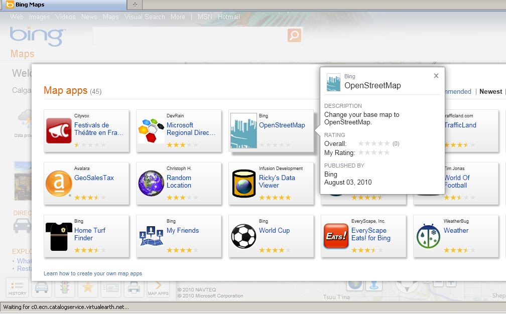
Open Street Map is now available in Bing Maps via the 'Open Street Map' App

Open Street Map now in Bing Maps
MapNik Tile Render via Bing Maps (OSM) APP


Open Street Map now in Bing Maps

http://www.bing.com/maps/explore/#5003/0.6002=
q:NYC:nelat:51.6120377517871:nelong:0.18654357910159:
swlat:51.4079622462129:swlong:-0.446543579101535:nosp:0:adj:0/5872/style=Mapnik&lat=40.65415&lon=-74.024291&z=11&pid=50735

In Addition there are some improvements to Bing Maps Explore:

  • Appearance: Cool colours create a more visually appealing backdrop that helps content ‘pop’ on the map, providing clear differentiation for pushpins, labels and red, yellow and green traffic overlays. 
  • New labels: Larger fonts correspond to larger roads, making it easier to identify major streets and throughways. Crisper labels eliminate the need for bolding and less-attractive glows, allowing users to quickly find locations in a relevant format.
  • Improved international coverage: Data updates deliver improved road and street detail across Central and Eastern Europe, the Middle East, Oceania and Asia.
  • Dynamic Labels (beta): This innovative map navigation allows you to quickly zoom to a region or location on the map with just a few clicks, making it easier to identify and explore areas or neighborhoods of a city. Turn on the dynamic labels beta from the map style selector on bing.com/maps/exploreand labels become clickable

Monday, August 2, 2010

Google Spam Map

Where Spam Originates

Google's e-mail and web security and archiving service Postini has created a Spam Threat Map. The map shows where e-mail spam messages are originating in real time (although the map itself doesn't appear to be real-time). 

It seems that many of those Nigerians wanting to give me money don't actually come from Nigeria. In fact according to the map Europe and India seem to be two of the biggest sources of the spam clogging up my e-mail service.

Google Map Animation with Map Rotation

TipCar


TipCar is a Brazilian car pooling website. Users of the site can offer and find rides quickly and easily.

The home page of TipCar features a cool animated Google Map which features profile pictures and short messages of people looking to share car journeys. The map animates through each message with some nice map rotation and map tilting between messages. You can see the animation effects in the video above. 

I'm pretty sure that the site also uses Google Maps to help users find and display car journeys. Unfortunately my Portuguese wasn't adequate enough to navigate to that part of the site.

NYC Property Records on Google Maps

Blocks and Lots

Blocks And Lots is a new API that provides easy access to NYC’s property records. The new API enables you to incorporate detailed property information into all kinds of web and mobile sites and apps.

The Blocks And Lots API gives you access to more than 5 million NYC property records from the Departments of Finance, Buildings, and City Planning.

In the demo of the service you can enter any NYC street address. The demo then accesses the Blocks and Lots API, finds the information about the property and displays the location on a Google Map. The information window displays building and owner information, assessment values and the sale history. 

EPA data now featured in Google Earth Outreach

Last month, we showed you the KMZ file that the EPA released that had a ton of data about the Gulf oil spill.
epa.jpg
Google has now featured that data on their Google Earth Outreach site. The depth of information available in this file is quite remarkable, and it's a superb resource for those that need more information about the spill.
Information available in the KMZ includes:
  • View EPA air, surface water, sediment and waste sampling locations in Google Earth, which are linked to explanations and information throughout this site.
  • See EPA air monitoring locations and results for total Volatile Organic Compounds (VOCs) and Particulate Matter (PM).
  • Link to EPA data, aerial photography and other information collected by our air sampling plane, the ASPECT.
  • Get National Geospatial - Intelligence Agency's (NGA) map of boom locations and daily tracking updates of the oil spill.
  • See aerial photography and satellite images from NASA, NOAA and the European Space Agency's satellite ENVISAT.
To keep up with the latest items featured by Google Earth Outreach, you can check out their website or follow them on Twitter at @EarthOutreach.

The Simple Ideas Are Often the Best

Story Map

This morning I was reading EDTE.CH's account of the recent Google Maps Session at the Google Teacher Academy UK meeting. The post has a lot of interesting resources for using Google Maps in the classroom but I was very impressed with one particular idea. The idea is to use Google My Maps to create interactive narratives.

To create a Story Map you create a Google My Map with a starter map marker. The first map marker should include a simple start to your story. In the example given a map marker was placed on Westminster Bridge in London with this opening for the narrative:

It was exactly where they said it would be. The Thames swirled below me from a passing barge as I lifted it too my chest.

The bridge seemed quieter than usual, and yet I could feel eyes watching. Which way now? I needed to get moving. I had already spent too long.

I turned and pressed on.

Once you have placed your opening map marker students can then choose from a number of story paths drawn on the map using the line tool, adding their own map markers and continuing the story.

I wish I had thought of this idea when I was still an English teacher. It definitely gets an A+ from me and is on a par with the excellent Edte.ch Maths Maps

All of Kuala Lumpur on Google Maps

MasMap-Online

Masmap overlays very detailed map tiles on top of Google Maps. So if you need a really detailed map of Kuala Lumpur you should use Masmap.

Masmap also includes all the normal Google Map views (map, satellite, hybrid, terrain) and an OpenStreetMap view. However if you use the Masmap view you have access to thousands of interactive points of interest. The POIs include churches, restaurants, hotels, shops etc.

Masmap also includes options to view Panoramio photos on the map and the option to search for a point of interest, a street or an area in Kuala Lumpur.

Mission Possible with Google Maps

Mission Explore

If you have children that you need to keep entertained this summer then you should introduce them to Mission Explore. Mission Explore is a series of challenges designed to get children thinking geographically.

The Mission Explore website already has over 1,000 missions. The project has started in London but the missions will be expanding to other locations soon.The Mission Explore London Map is a Google Map showing the location of the available missions.

The missions are imaginative and fun challenges for children to undertake. For example one mission is to cross a park without being seen by any squirrels. Another mission involves finding as many different types of trees, plants and flowers in a public garden as you can.

Parents who don't live in London are sure to find inspiration for entertaining their children with Mission Explore. As you can see many of the missions can be easily transferred and don't necessarily have to be done at their mapped location.

You can also download the free Mission Explore London iPhone app. With the app you can find the nearest mission to your location when you are out and about in London. The app also has an 'Anywhere' button that provides missions that aren't specific to London locations and can be undertaken anywhere.

Sunday, August 1, 2010

Exploring Quebec with Google Maps

Bonjour Québec

The official tourist website of the Government of Québec has produced a Google Map to showcase the sights and activities available in the Canadian province.

The map markers allow visitors to Québec to find accommodation, attractions and activities for their trip. It is possible to view the map markers by category. For example if you are looking for accommodation for your visit you can choose to view just hotels, just campsites or only B&B's.

If you click on a map marker you will get further details about the point of interest selected. You can also get driving directions and view the chosen location in Street View.

Via: Le Technoblog du LAC