Friday, July 9, 2010

Berlin and Stuttgart are now in 3D


Google released quite a few 3D buildings yesterday. Not only did they publish my house (and presumably hundreds of other user-generated models), but they released two more full cities in 3D -- Berlin and Stuttgart.

stuttgart_SchillerplatzSquare01.jpg

As with their other recent 3D cities, these are very impressive with many thousands of models in each city.
Here is a video overview of the new buildings:

For more about this release, you can check out the Google SketchUp Blog.

Netherlands Google Maps Round-Up


The following Dutch Google Maps mashups were all submitted to the Google Maps API 5th Year Anniversary Map. Have you added your map yet?


This Dutch Google Maps mashup can help you find locations that are related to nature and the environment in the Netherlands.

The huge amount of information on this map is organised into a number of categories. Form the map sidebar it is possible to select from 'Sustainable Economy', 'Flora & Fauna', 'Culture', 'Information', Energy & Recycling', 'Infrastructure', 'Land & Water', 'Recreation', 'Mobility' and 'Pollution'. Each of these categories has itself a large number of selectable subcategories.

Each information window contains an embed option to show a small map of the current point of interest on your own website or blog. There is also the option to get more detailed information about the location and to get driving directions.

This Google Map shows the location of all supermarkets in the Netherlands. Users can search the map to find their local supermarket. Each supermarket map marker includes a link to the store's website.

This Google Map shows the opening hours of shops in the Netherlands. You can search the map by location and by type of shop.

The shops in the Opentot database include supermarkets, DIY, electronic, pharmacies, garden centres, warehouses and real-estate agents.


RouteNX is an amazing route planner for the Netherlands that solves the travelling saleman problem of finding the quickest route when you have multiple stops to make on a journey.

Add your addresses to the map and RouteXL will plan your route, taking in all your stops and in the optimum time.


Thursday, July 8, 2010

Twitter and Driving Directions

Raste Pe -On Your Way

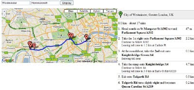
This a basic but interesting Google Maps mashup. The map uses the Google Maps API driving directions with the Twitter API to give driving directions with Twitter messages along your route.

The driving directions are presented in the normal manner, with the length and time of the journey and numbered directions. The Twitter messages along the route are shown with red map markers. If you click on a marker you can read the message and view who it was posted by.

I guess this could be very useful if it was combined with traffic information to give you real-time news along a route that you about to drive.

The Geocaching iPhone App


If you love Geocaching then you will love this iPhone app. Geocaching is a treasure hunt type game in which players try to locate hidden containers, called geocaches. If you download this geocaching app to your iPhone you can get a list of nearby geocaches wherever you are.

Groundspeak's iPhone Application queries the Geocaching.com database in real-time and provides a list of geocaches near you. Using the application you can view nearby caches on a Google Map. You can also view the cache size, terrain and difficulty rating directly from the map screen.

A benchmark is a point assigned by a land surveyor or cartographer whose position is known to a high degree of accuracy. A benchmark is usually marked in some way, often by a specially made metal disk but a benchmark can also just be prominent feature such as a church spire or a radio tower.

Benchmark hunting is a sub-game of geocaching. Using a GPS unit and/or written directions some geocachers like to hunt down NGS survey markers and other items that have been marked in the USA.

This benchmark viewer uses Google Maps to show the locations of NGS benchmarks as gathered from the Archived ShapeFiles Retrieval Page on the NGS Web Site.

Previously Featured

The largest geocaching website is Geocaching.com with hundreds of thousands of caches. The website includes about 904,000 caches in over 200 countries around the world.

GeoJournal is the first application of it's kind written for the Mac to manage your Geocaching adventures. It's got a ton of great features that allow you to plan, manage, and record all of your geocaching adventures.

A Wired article explaining how to take part in a geocaching event using Google Maps without a GPS unit.

New York Named Buildings on Google Maps


Tektonomastics haven't just created a Google Map they have created a whole new branch of onomatology (the study of the history and origin of proper names). 'Tekto' is Greek for buildings, so 'Tektonomastics' is the study of building names.

Combine Tektonomastics with geography and you get a Google Map showing the location of buildings with proper names. By taking photographs and mapping the locations of the named buildings in New York, Tektonomastics hope to help these neglected building names live once more.


My only problem with tektonomastics is that they don't appear to have a taxonomy. I suggest they introduce a tagging system for their mapped buildings. Buildings on the map could be tagged by those named after 'people' (with a sub-category of presidents), those buildings named after geographical places) etc.

World Map 16th Century


Description: World map made by Laurent Fries, woodcut 1522.

Want your home or business in 3D? Estate3D will do it for $99.


Many people out there would like to get their home or business modeled in 3D for Google Earth, but don't have the time or expertise to use Google SketchUp to do it themselves. Over time,Building Maker may provide a good way to do it, but right now it only covers a tiny fraction of the earth and the models tend to be lower quality than hand-designed buildings. What do you do in the meantime?
We talked last year about a few options. Concept3D and CyberCity3D both have packages available, and both do excellent work. The only problem is the pricing; Concept3D starts at $325, and CyberCity is likely in the same area (though they don't list prices). They're certainly worth the price, but what if you just want a simple model? Enter Estate3D.
Estate3D is a new service that will model your home or business for just $99. They'll supply you with the resulting KMZ file and they'll submit it to Google for you so that it'll appear in Google Earth in the main "3D Buildings" layer.
For $99, they'll do a single building that's composed of 50 faces or less; more than enough for most individual buildings. You simply take photos of your building, upload them through their site and give them a few days to turn it around. I had them do my house so I could see how the process worked, and you can can see the result below or view it in Google Earth (3D Warehouse, KML). It's a simple model, but they did a nice job with it. Along with the basic house, they added things like the front porch, back deck and the chimney.
estate3d.jpg
They also provide you with an embed code so you can show the building off on your own website via the Google Earth API. This means users of your website will be able to navigate around the model in 3D, right in their web browser. Here is an example:
If you have a model that you need done, I highly recommend you check them out.
A few notes about that model: The cut-off garage doors are a result of some crazy hills on our property, not the fault of Estate3D. Fixing that would require some terrain editing, which goes well beyond what they do. Also, the trampoline and fort in the backyard are not part of their typical package; just a fun bonus to enjoy. Estate3d will take on any unusual Google Earth modeling tasks you might have - if they go beyond the bounds of their $99 package you can simply apply for a "custom building".

A Sailing Calendar on Google Maps


This Google Maps mashup displays a calendar of upcoming sailing events around the world and shows the location of each event on a map.

You can use the calendar to navigate the map by date. It is possible to quickly navigate to any month, week or year. If you click on an event in the calendar the map will pan to show its location.

You can also browse the events by location. If you click on any of the mapped sailing events the calendar will display the date and time that it is scheduled for.

Who'll Win the World Cup Map Survey?


SurveyMapper is a free real-time geographic survey and polling tool from the ever resourceful Centre for Advanced Spatial Analysis. There are a lot of other web based ‘polling sites’ already in existence but SurveyMapper is the first I've seen that allows you to observe the results in real-time on a Google Map.

To get an idea of how SurveyMapper works check out the results of this public perception of crime survey. If you look at the mapped results for London you can see how effective it is is to have a geographical view of the data. The map clearly shows how residents in East London perceive crime in their area as very high, whereas West Londoners are far happier in their perception of crime.

Currently SurveyMapper is in beta testing in the UK, with coverage down to postcode level. Users can create a survey about anything they want and can survey the nation, a county or just a street. Once a survey closes you can download the data and use it for anything you wish or simply examine the map and the statistics.

SurveyMapper plans to expand to Europe shortly and then to the United States and after that the World, allowing surveys and polls down to building level.

Oh, If you have an opionion about who will win the World Cup you can vote on this World Cup 2010 map survey. Perhaps surprisingly the Netherlands, at the time of writing, are in the lead.

Ordnance Survey Map in Bing Maps - Silverlight


Ordnance Survey Map in Bing Maps 1:25k and 1:50k Mapping Scales

Ordnance Survey 50k Landranger Bing Maps Silverlight

Ordnance Survey 1:50,000 (Landranger series) scale mapping in Bing Maps

Ordnance Survey 25k Landranger Bing Maps Silverlight
Ordnance Survey 1:25.000 (Explorer series) scale mapping in Bing Maps