It’s Christmas Eve, and you know what that means. Santa Claus is busy delivering toys to boys and girls around the world. Where is Santa Claus right now? Below, our annual round up of ways to find Father Christmas, from tracking Santa on Google Earth to monitoring him from your iPhone.
NORAD’s Santa Tracking Monopoly
I’ve been writing about Santa tracking for five years now. Back in 2005, there were a variety of Santa tracking services out there. Since then, most of them have given up and simply point toNORAD Tracks Santa. That’s fine — NORAD does a great job.
NORAD is the joint US-Canadian missile tracking organization. But for more than 50 years, NORAD has also been tracking Kris Kringle due to a misprinted phone number. Since 2007, NORAD partnered formally with Google to produce an entire suite of Jolly St. Nick monitoring tools.
Below, a close-up of specific options from NORAD, with links to the English-language instructions. Need another language? Select from the NORAD site’s home page. After NORAD, I’ll also cover what alternatives remain.
NORAD’s Santa Map & Videos
Using high speed photography, along with fighter jets, satellites in orbit and radar installations to locate him, NORAD films Santa Claus as he passes over landmarks in countries around the world. A map shows where he’s been:

Above, you can see I snapped this image when Father Christmas was in Jakarta, Indonesia — as shown at the bottom of the screenshot.
If you click on Santa himself, you’ll see his current location:
 ‘
‘
Click on any of the gift icons to read more about places he’s already been to:

Finally, select any of the video camera icons you’ll see over select cities, and you’ll be treated to Santa doing a fly-by of local landmarks:

There’s also a Videos page that lists videos of all places that Santa has visited so far:

A collection of videos can also be found on the NORAD Tracks Santa YouTube channel.
Call Or Email For Santa’s Location

I’m old school. I like the fact that NORAD still allows you to call by phone and talk to a real person about where Santa is. Be sure to wish the volunteer tracker a Merry Christmas! The phone numbers are:
Within US: (877) HI NORAD / (877) 446-6723 International: +1 (719) 556-5211 (Cost may be incurred) Hearing Impaired should contact their service provider.
You can also email noradtrackssanta@gmail.com to get an update. Personalized, even!

More information about calling or emailing for the location of Santa Claus, including hours of operation, are here.
Real-Time Santa Tracking Via Google Earth
In previous years, Google released a special file for Google Earth users, to track Santa. This year, it seems to be providing only a special plug-in that allows Google Earth viewing via your web browser. But, that’s pretty cool.
Visit this page with your web browser, and you’ll be prompted to install a plug-in. After that’s done, you’ll see Santa in real-time, as he flies above the earth:

I like how when he comes to a major city, suddenly he zips around delivering presents so fast that all you see is a series of red streaks.
By the way, Google Maps itself has gotten dressed up for the holidays, or at least the Street View “Pegman” has:

Santa Pegman Comes To Google Maps is our story that explains more about this.
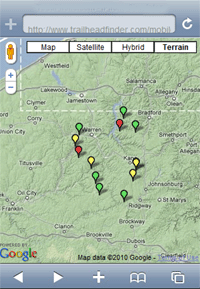
Santa By Google Maps For Mobile
On the move? Google makes it possible to track Santa using your smartphone. If you haveGoogle Maps For Mobile (which is offered for Android, iPhone and BlackBerry), just do a search for “santa,” and his current location will be shown:

OK, it’s not the greatest presentation in the world, but it’s easy, and it works.
Santa By iPhone
After some exploration, I think the Santa Tracker 2010 from Talus Media is your best bet for the iPhone. It’s only $1, and it pinpoints your location (that yellow spot on the left), Santa’s location (the red dot on the right) and presents a countdown clock:

I especially like “The List” feature, which has a “naughty” and “nice” list. Using the main settings menu in the iPhone, you can add your kids to either list. I like to tease them and switch them around throughout the day.
Santa By Android & BlackBerry
I can’t link directly to Android applications because the online version of the Android Market makes it nearly impossible to find things there (no way to search, on a market backed by Google?). However, here’s a rundown on what you might try when searching through the market from your Android phone.
![]()
Santa Tracker Live from Active9.com brings the NORAD Santa Map I highlighted above into your Android phone. However, I found that the Flash videos didn’t work — and this using a Nexus S phone with the latest Android 2.3 software. The app is also very sluggish, but at least you can see Santa on it.
Santa Tracker from Value Apps simple draws a short line from wherever you are to a point indicating that Santa isn’t that far away. Handy if you’re trying to get the kids into bed earlier, especially since NORAD’s system is useless for building excitement that Santa is about to approach, for kids that are put to bed in the early event. With NORAD, it’s assumed Santa only approaches at midnight. Every year, I wish it offered a time-shifting ability. Anyway, the app is slow, buggy but free.
Santa Tracker Christmas is a $2 app from Onteca. It offers a pretty boring current location view. The past sightings are kind of need, with various images of Santa caught in flight in black and white. I wouldn’t recommend buying it, however.
Santa Spotter from Ogilvy Group is kind of neat, in that you swing your phone around toward the sky to spot Santa. Problem is, you never really seem to find him. You do have constellations that light up, which is pretty cool. And, it’s free. It kept crashing on my Nexus S. On my Samsung Fascinate running Android 2.1, it worked fine.
As for the BlackBerry, you might try Santa Tracker For BlackBerry. I haven’t used it, but CrackBerry has a review of this $3 app.
Other Santa Trackers
As I said when starting this article, most alternative Santa trackers out there just seem to point back to the NORAD site. This year, I found only one providing a worthwhile alternative experience,Santa T:

Nothing fancy — but I like how the single page view can give little kids the idea they are sitting at a radar control station. The time countdown is automatic. Santa T probably looks at your computer’s IP address to determine its time zone.
Santa Claus & Twitter
Got Twitter? Then you’ve got Santa tracking. NORAD provides update through Twitter via the@noradsanta account:

Santa Claus & Facebook
Yes, Santa is one of the 500 million people using Facebook! OK, actually, it’s NORAD again, providing updates through the NORAD Santa fan page:

Merry Christmas!
To everyone celebrating Christmas, here’s wishing you a great one.


 , but read on for other ways to follow his journey throughout the day.
 As another fun bonus, Google has just added a Santa hat to "Pegman" (the Street View character) in Google Maps. He doesn't change the functionality of Google Maps at all, but just makes things a bit more festive!