Bonjour Québec The official tourist website of the Government of Québec has produced a Google Map to showcase the sights and activities available in the Canadian province. The map markers allow visitors to Québec to find accommodation, attractions and activities for their trip. It is possible to view the map markers by category. For example if you are looking for accommodation for your visit you can choose to view just hotels, just campsites or only B&B's. If you click on a map marker you will get further details about the point of interest selected. You can also get driving directions and view the chosen location in Street View. Via:Le Technoblog du LAC
Mappybirthday For the fifth anniversary of the Google Maps API I helped Google create a Google Maps mashup that allows map developers to pin their Google Maps mashups to a map. The idea was to highlight some of the amazing maps that people have created with the API all over the world. The map is hosted on Google App Engine and uses Google Fusion Tables to store users' submissions. To help other map developers create their own user submitted maps for Google App Engine the source code for the map has now been added to Google Project Hosting: Mappybirthday on Google Code Mappybirthday itself now has nearly 600 maps listed and is becoming a reasonable resource to find local maps. For example, if you zoom into San Francisco, you can find a Google Map that will help you find somewhere to rent, a map that lets you view real-time ship positions in the Bay, a real-time map of NextBus buses, and a map of crime in San Francisco. Of course if you add a map to Mappybirthday you might also find your map is reviewed on Google Maps Mania!
Tours from Above Luckily it is the weekend, which means you can probably afford to have your attention consumed by Tours From Above. Tours From Above is a showcase for some of the world's best aerial panoramic photographers and some of the most amazing 360 degree panoramas you will ever see. The site uses Google Maps to show you the locations of aerial panoramas. These panoramas allow you to view oceans, forests, waterfalls and some of the world's cities in a way that you have never seen them before. It is truly breathtaking to view New York's skyscrapers in a 360 degree panorama taken from the air. If you get bored of New York you can use the Google Map to fly over to Zambia to view a gorgeous panorama of the Victoria Falls from above. I'm not going to waste any more of your time talking about Tours From Above. You are going to need all the time you can spare to view these amazing panoramas. So, go visit!
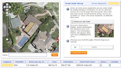
Save the Rain This Google Map can help you calculate how much rain water you can harvest from your property. One way to prepare for the effects of global warming on water supply is to capture rain water running off of roofs. This process is known as rainwater harvesting. The rainwater can then be used to flush toilets, and, even do laundry. Save the Rain can help you calculate how much rainwater your roof could capture. This is done by simple calculating the area of your roof, and, multiplying by the mean yearly precipitation. To use the map just enter your address and then find the satellite image of your house. Once you have identified your house all you have to do is draw around your roof and press 'finish'. Save the Rain will then calculate the area of your roof, the amount of water you get in a year and how much water you could harvest. Also See Roofray Have you ever thought about adding solar panels to your house? Roofray can help you decide. Roofray is an amazing tool built on Google Maps that can calculate the solar energy potential of your house. To do this you start by simply tracing a a polygon on top of the Google Map satellite image of your house. When you have traced your roof you then drag a marker on the map to show the direction your roof slopes. The next step is simply to enter the angle of your roof tilt. Once you have entered your details Roofray calculates your month-to-month photovoltaic output levels based on your coordinates and regional characteristics such as the average weather cycle, cloud cover, surface albedo, and the orientation and area of your solar array.
Over the last couple of days I've been working on trying to copy Microsoft's excellent demo of Street Slide with Google Maps Street View. You can see Microsoft's demo in the video above. You can view my latest attempt at recreating the effecthere. I've used Jamie Thomspon'sStreet View Tile Viewerto grab static images from Google Street View to provide the side on views. For each Street View I've grabbed two static image tiles. You can see which two tiles I've used in the screenshot above. I've then placed the two images side by side and then placed them side by side with two static images from the next Street View and so on down the street. If you look closely at the static images in mydemoyou can see that the adjacent Street View images don't stitch together perfectly. If you wanted you could stitch the images together a little better if you worked on them in Photoshop. If you are better programmer than me you could probably create the static images directly from javascript using nextPanoId to grab the panoId for adjacent Street Views. In this way you could probably create the static image side street view directly from javascript for any location in the world that has Google Maps Street View. At the moment in my demo if you want to switch back from the Street View to the static side view you need to click the link under the Street View. My next step will be to replace the Google Maps controls in Street View with custom controls. With a custom control for the zoom I should be able to switch to the static view when the user zooms out of Street View (e.g. when the street view = 'zoom:0'). If you want to try any of this yourself you are free to reuse my code. Bonus Demo- I got a little bored of working on Street View Slide so I decided to use the Street View Tile Viewer to create this little animation of Oxford Street, London.