Friday, December 24, 2010
Pegmans Gets A Hat

Thursday, December 23, 2010
Friday geonews delayed... happy holiday break to all!
MapQuest Introduces Open.Mapquest.com
The official MapQuest blog introduces open.mapquest.com.
From the announcement: "After the successful launches of 10 open-sourced maps in Europe and Asia in partnership with OpenStreetMap (OSM), MapQuest is proud to launch its U.S. site located at Open.Mapquest.com. [...] Open.Mapquest.com provides the same features as our 10 sites in Europe and Asia, and also debuts a new error-reporting tool (which has been added to all of MapQuest’s open sites). For many, this tool may be their first step in becoming OSM contributors."
New Poll on 2011 and Poll Results on The Future of the Shapefile Format
About time we change our front page poll. The new poll asks you about what 2011 in geospatial will be like.
The results and comments on the poll about the future of the Shapefile formatare pretty interesting. Out of 347 answers, 35% believe the shapefile will stay with us forever and 25% believe SpatiaLite will become the choice of many. Otherwise, it's pretty mixed results, 13% admit they don't know, 11% think that web services will eventually replace flat files, 8% think the GML standard will become widely used, the same amount of people believe ESRI's Geodatabase format will eventually replace the shapefile format. Please also take a look at the insightful comments shared by our users for that poll.
Living in Toronto, Looking for a Condo

TheRedPin is Toronto and the GTA's first one-stop condo destination, where condo buyers can find all project details, such as floor plans, amenities, model suites and more. On top of the project details, buyers also have access to a wealth of neighbourhood information, such as nearby schools and daycares, investment stats and neighbourhood amenities.
You can search for a condo using TheRedPin Google Map. You can search by location, price and by number of bed and bathrooms. TheRedPin also uses Google Maps to provide local amenity information as well as sales office directions for each condo project
Wednesday, December 22, 2010
Local News & Events with Google Maps
EveryMap

Australian website EveryMap is a local report website that allows people to share what is happening or has happened locally.
Users of EveryMap can submit reports on anything from upcoming local events, local news, problems that need fixing to their favourite bars and restaurants. Submitted reports are then added to a Google Map.
It is possible to search the reports posted to the map by category and by time. EveryMap includes a very useful timeline function that allows you to adjust the reports shown on the map by a starting and closing date.
Finding Hiking Trails with Google Maps
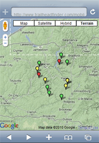
TrailHeadFinderTrailHeadFinder, the hiking trail directory, has released a mobile version of its Google Map of trails and campgrounds.
Using the application from your phone it is possible to find the nearest trails and camping grounds to your nearest location.
The difficulty of trails are indicated by the colour of the map marker on the map. Red markers indicate strenuous trails, yellow markers show intermediate trails and green markers show that the trail is fairly easy.
________________
Labels: Google Maps for Mobile
Australian Budget Travel with Google Maps

A report (PDF) published by aus-emaps.com shows where to find the cheapest holiday accommodation in each state and territory in Australia. The report is accompanied by an online Google Map illustrating the report's findings.
The report is particularly useful for budget conscious travellers who could make substantial savings if they aren't fixed on specific locations. For example, in Queensland, Fraser Coast north of Brisbane offers much better prices than adjoining Sunshine Coast (which is almost 50% more expensive) and the Gold Coast (approximately 35% more expensive).
The researchers examined average takings per night by accredited accommodation service providers in each tourism region around Australia and mapped out the results. The outcome is a colourful map matrix that highlights regions with both the cheapest and the most expensive accommodation.
On a state and territory basis, Tasmania has the cheapest accommodation while the Australian Capital Territory is comparatively the most expensive ($128 and $163 respectively). The cheapest region in Australia goes to Victoria's Wimmera region, which has an average accommodation cost of just $83.82 per night. Close second is South Australia's Yorke Peninsula ($85.36), followed by Northern Territory's Barkly ($87.98), Victoria's Upper Yarra ($90.48) and Outback NSW ($93.14).
Holiday trees in 3D
Tuesday, December 21, 2010
New Orleans Gets Birds Eye View

New Orleans is now covered by Google Maps' oblique satellite views. I'm sure there must be more cities that have been recently added but New Orleans is the only one I've found so far.
This Google Map shows the cities around the world that Google have aerial views for (New Orleans has yet to be added). I've updated my Aerial View Mapto include aerial imagery of the Louisiana Superdome and Jackson Square in New Orleans.
I've also updated the Bird's Eye View with the new imagery. This map allows you to compare Bing Maps' Bird's Eye View side by side with Google Maps' aerial view.
________________