Tuesday, December 21, 2010

New Orleans Gets Birds Eye View


New Orleans is now covered by Google Maps' oblique satellite views. I'm sure there must be more cities that have been recently added but New Orleans is the only one I've found so far.

This Google Map shows the cities around the world that Google have aerial views for (New Orleans has yet to be added). I've updated my Aerial View Mapto include aerial imagery of the Louisiana Superdome and Jackson Square in New Orleans.

I've also updated the Bird's Eye View with the new imagery. This map allows you to compare Bing Maps' Bird's Eye View side by side with Google Maps' aerial view.

________________

The Google Map of Love's Labour's Lost


Tuesday, December 21, 2010

" layout="standard" show_faces="true" width="450" action="like" colorscheme="light">

You Were Cute

So you have this crush on the guy / girl of your dreams but you can never conjure up the courage to ask them out.

What do you do?

Well, you could try You Were Cute, a new Google Map application that hopes to help you with your missed connections. You can add a message to the Crush Map at any location simply be completing a short form.

Hopefully the object of your crush will then find your message on the map, reciprocate in kind and, well, the rest is really up to you.

I do love this Google Map. It is such a simple idea brilliantly executed, with just the right note of poignancy.

Create a Google Map in 60 Seconds

Mapbiquity

Mapbiquity is a Google Maps based creation tool that can help you create a Google Map for your website.

Mapbiquity helps you build a map with your own data. To create a map all you really need to do is upload some Shapefile data. You can then style the map to fit the design of your website.

When you have completed you map you can then add it to your site by cutting and pasting a short piece of code.

Monday, December 20, 2010

Where Will You Watch the Lunar Eclipse?

Event Map: Where Will You Be?

NASA have created a Google Map so that you can share where you will be watching tonight's total lunar eclipse. NASA hopes to build a community of moon-gazers across the country by everyone sharing their lunar eclipse viewing spots, comments and photos.

You can add yourself to the moon-gazing map by entering your 10-digit cell phone number on the NASA website. NASA will then text you with tips and resources for viewing the eclipse. You can then text NASA your zip code and they will add you to the map.

Remember you can also tune into NASA's live video feed of the eclipse and view a simulation of the eclipse on the Google Earth browser with HeyWhatsThat's Event Map: Where Will You Be?

Regional Accents on Google Maps

Map Your Voice

The British Library has created a Google Map to record and map English accents around the world.

The British Library are asking people all over the world to read and record the children's story 'Mr. Tickle' by Roger Hargreaves. The story has been chosen for the range of English sounds it contains when read out loud.

You can listen to the recordings already made by clicking on the map markers on the map and pressing play on the embedded audio player.

This isn't the first sound map produced by The British Library. The UK SoundMap is a Google Map of soundscapes captured around the UK.

Via: ReadWriteWeb

Telling Stories with Google Maps

MapSkip

MapSkip is an interesting Google Map that allows users to map stories about places. The stories can be about the place you fell in love, where you had a dream vacation or where you took a great picture. Alternatively your stories can be about the places that are important in your life, such as where you live, eat, work and have fun.

MapSkip has a community of over 1,000 registered users and has mapped over 1,200 stories. MapSkip is particularly popular with many schools and teachers. The site allows teachers to create student accounts and adjust settings so that students' work is not visible to others. A Teacher's Interface also allows teachers to review stories submitted by their students.

The MapSkip map of submitted stories can be filtered to show only your added stories and places, to display only your favourited stories, or only stories that have sound or video.

Sunday, December 19, 2010

Create a Google Map in 60 Seconds

TIXIK.com

If you need to create a simple Google Map then TIXIK.com can help. Using this map creator you can create an embeddable map for your website in a matter of seconds.

To create a map you just need to enter a location. A Google Map showing the location is then displayed with the code to embed the map on a website. If the location needs adjusting you can drag the map marker to the correct position.

TIXIK.com also allows you to adjust the height and width of your map, set the map type, the zoom level and adjust the map border.

The Lunar Eclipse Simulator

HeyWhatsThat: Eclipses

Early in the morning of December the 21st, on the winter solstice, there will be a total lunar eclipse. If you live in North America you should have great views of the eclipse. If you live in Western Europe you should be able to see the beginning of the eclipse.

HeyWhatsThat: Eclipses uses the Google Earth plug-in to simulate solar and lunar eclipses. Using Eclipses you can watch a simulation of the lunar eclipse from your location. Use the timeline beneath the Google Earth plug-in to view the eclipse at different times during the night.

If you live in the southern hemisphere you can enjoy the summer solstice. However you can also tune into NASA's live video feed of the eclipse.

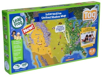
usa maps


Map of the USA that is compatible with the Tag™ reading system. Loaded with facts about individual states and regions. For ages 4 - 7.


offiial site

Saturday, December 18, 2010

Imagery Update - Week of December 12th

‘Tis the season of giving! For those of you who’d like nothing more than to receive the gift of new places to explore on Google Earth and Maps, you’re in luck. Our imagery team’s latest update includes many places that relate metaphorically to the holiday season.

For example, it’s often at the end of the year that we remark “Out with the old, and in with the new.” That concept can also be applied to the below image that captures two military installations located North West of Beijing. You can see the fascinating juxtaposition of the modern Yongning Air Force base (bottom right) and an adjacent section of the ancient Great Wall of China (upper left quadrant) that outlines parts of the Shibapan Ling mountain range. And yes, you really can see the wall from space!

Near Beijing, China

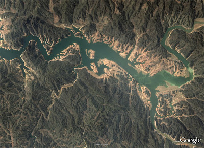
Wouldn’t gold make a great stocking stuffer? Take a look at the below image of Jin Xixin Lake, the dammed section of the Minjiang River also known as the Gold Lake, located south of Mount Wuyi, China. In this image, you can see lots of prime locations that might make great prospecting camps. Get out your pans!

Gold (but no frankincense) near Mount Wuyi, China

Finally, although this time of year is often associated with the Christian-based holidays, when thinking about China, thoughts naturally turn to Buddhism. Just the other day on the Google campus in Mountain View, a group of Tibetan monks visited to build a Sand Mandala and lead a meditation group. In this spirit, I’ve included the below image of the first Buddhist monastery built in Tibet, the Samye Monastery.

A site of enlightenment in Tibet

The examples above only hint at the type and breadth of features that can be seen and discovered in our latest batch of published imagery. Happy exploring and happy holidays!

High resolution aerial updates:
USA: Birmingham AL, Little Rock AK, Peoria IL, Tuscaloosa AL, Worcester MA, Jerome ID, Stevenson WA, Knoxville TN, Morganton NC, and Statesville NC
Canada: Powell River, and Sunshine Coast, BC., Canmore, and Cold Lake
Netherlands: Hilversum
South Africa: Northern, Eastern, and Western Cape, and Limpopo
Sweden: Gävleborgs Län, Jönköpings Län, Uppsala Län, Västerbottens Län, and Västra Götalands Län

Countries receiving high resolution satellite updates:
Albania, Algeria, Angola, Argentina, Armenia, Australia, Austria, Azerbaijan, Bahrain, Bangladesh, Belgium, Bhutan, Bolivia, Bosnia and Herzegovina, Botswana, Brazil, British Virgin Islands, Brunei Darussalam, Bulgaria, Burkina Faso, Cambodia, Cameroon, Canada, Chad, Chile, China, Colombia, Costa Rica, Croatia, Cuba, Democratic People's Republic of Korea, Democratic Republic of the Congo, Denmark, Dominican Republic, Ecuador, El Salvador, Estonia, Ethiopia, Finland, France, Georgia, Germany, Greece, Guatemala, Haiti, Honduras, Hungary, India, Indonesia, Iran, Ireland, Israel, Italy, Japan, Jordan, Kazakhstan, Kenya, Kuwait, Kyrgyzstan, Laos, Latvia, Lesotho, Liberia, Libya, Lithuania, Luxembourg, Madagascar, Malawi, Malaysia, Mali, Mauritania, Mexico, Mongolia, Montenegro, Morocco, Mozambique, Myanmar, Namibia, Nepal, Netherlands, New Caledonia, New Zealand, Nigeria, Norway, Oman, Pakistan, Panama, Papua New Guinea, Paraguay, Peru, Philippines, Poland, Portugal, Puerto Rico, Republic of Korea, Romania, Russia, Samoa, Saudi Arabia, Senegal, Serbia, Slovakia, Slovenia, Solomon Islands, South Africa, Spain, Sri Lanka, Sudan, Sweden, Switzerland, Syria, Taiwan, Tajikistan, Tanzania, Thailand, Turkey, Turkmenistan, Uganda, Ukraine, United Arab Emirates, United Kingdom, United States, Uruguay, Uzbekistan, Venezuela, Vietnam, Virgin Islands, West Bank, Yemen, Zambia, Zimbabwe

These updates are currently only available in Google Earth, but they'll also be in Google Maps soon. To get a complete picture of where we updated imagery, download this KML for viewing in Google Earth.