The iPhone 4 officially landed in China yesterday, so I bought one from the new Apple Store at Xidan in Beijing. In China, Apple sells its iPhones unlocked and without a contract (16GB = USD747, 32GB = USD895), so you can pretty much stick in any sim card and go. This is how I like my phones — and why I skipped buying an iPhone 4 in Sweden or the US (contract-only) or Belgium (hefty VAT markup).
I soon discovered that the Chinese version of the iPhone 4 comes with an aggravating quirk, though: The built-in Maps app is crippled. My phone's base map is hard-wired to Google Maps' censored dataset for China, where the depiction of China's borders complies with the official propaganda of the Chinese government. It does not, for example, show the region of Arunachal Pradesh as being disputed by China and India. On my phone, it belongs to China, even though the facts on the ground belie it — it is currently administered by India.
I discovered this quirk because the first thing I did after activation was to do a wholesale install of the backed-up contents of my old iPhone 3GS, bought in Hong Kong. On my 3GS, I knew exactly how the Maps app worked: If I went online in China without a VPN, the Google Maps dataset was an English-language version that nevertheless had borders which complied with Chinese law (i.e. they show Arunachal Pradesh as being Chinese). As soon as I turned on my VPN to tunnel into San Francisco, the refreshed base map automatically showed the proper international version, the one which the rest of the world gets to see. You could make the case that Apple and
Google just want to comply with local Chinese law — even though
the legality of Google's mapping service in China is even now in question, as it still needs to comply successfully with a new Chinese law that requires a license to publish online maps in China.
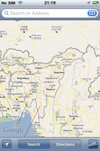 Hong Kong iPhone 3GS online in Beijing, no VPN
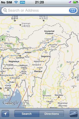 Hong Kong iPhone 3GS online in Beijing, VPN enabled
But my new Chinese iPhone 4 does things differently, even though ostensibly it is meant to be running exactly the same software as my old phone. The Maps app always shows China's borders as the Chinese government would have them — regardless of whether I use my VPN or not. If I take this phone to the US or Europe, it will still show the same crippled, semi-fictional base map. And there is no way that I can change it.
 Chinese iPhone 4, online in Beijing, VPN enabled
(The Chinese iPhone 4's dataset is slightly different from the one served inside China to my Hong Kong iPhone 3GS, however: on my Chinese iPhone 4, place names outside China are both in Chinese and English (and sometimes also in a local script, such as Arabic). San Francisco, for example, is accompanied by its Chinese name, 旧金山. That's not the case on my Hong Kong iPhone 3GS — all names outside China are just in English (and sometimes also in a local script).
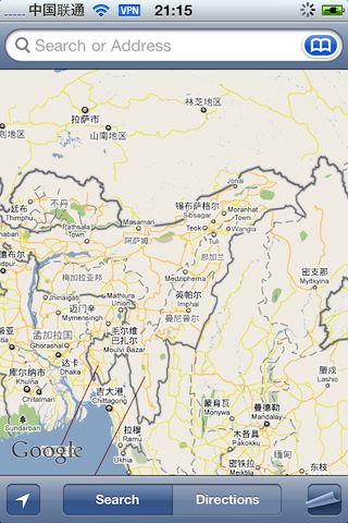
 Hong Kong iPhone 3GS, online in Beijing, no VPN
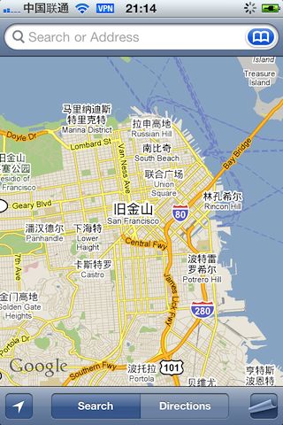 Chinese iPhone 4, online in Beijing, VPN enabled
In other words, Google keeps and serves two base map datasets that comply with Chinese law — one in English, and one in Chinese.)
This is not the first time Apple has willingly crippled its iPhones to legally access new markets. In Egypt, the first iPhones
lacked a GPS receiver to comply with a local ban. The first Chinese iPhones
lacked wifi. iPhone 4s currently sold in the United Arab Emirates
lack the Facetime feature, possibly to abide by VOIP regulations.
The question is whether crippling the Maps app on Chinese iPhones is a legal requirement, or whether it's a case of Apple (and Google) going beyond the call of duty. Is it really illegal to sell a phone where the software settings allow you to choose a base map different from the default? In any case, is it a good idea to rely on a map that may not ever get a license to be legally served in China? Shouldn't that possibility argue for the ability to choose different base map datasets (OpenStreetMap, for one, perhaps Bing Maps)? Right now, the Maps app reminds me of those cold-war era Soviet radios, without a dial, able to receive just one (propaganda) channel.
Because Apple's own apps are not deletable, I've now buried the Maps app in an obscure folder, and instead replaced the icon with a direct link to maps.google.com, whose mobile-enabled mapping template is just great: Compared with Apple's app, it serves up a reality-based map in China even without VPN, has much better search (with suggestions) and content such as Wikipedia and Panoramio photos. (Directions are lacking in the mobile version, though.) Another option is to use Google Earth for the iPhone, which looks simply awesome on the iPhone 4's screen.
Luckily, routing around censorship on the internet is still easy, though not with any help from Apple, in this case.


