This Labor day brought Colorado its most destructive wildfire to date, as measured in structures lost. 169 homes were destroyed and 6,181 acres of mountain terrain were scorched as the Four Mile Canyon fire blazed its way through our hillside.
Community members worked together to create a collaborative map to show the location of the fire and track its progress. The map was open for anyone to contribute information as soon as it became available. For many, this was a primary source for the most up-to-date information available about the fire.
View Boulder Fire Area in a larger map
Additionally, new imagery from GeoEye of the burn area is now available as a KML overlay. We will be adding this to our base layer soon. When viewed in 3D using Google Earth, this image vividly illustrates the extent and magnitude of the damage.
Our profound gratitude goes to the fire fighters who worked tirelessly to subdue the fire in the face of high winds and difficult terrain. If you would like to help, you can learn more here.
Thursday, September 16, 2010
Live webinar for businesses on 9/23: Google Apps for mobile
With the rapid adoption of Internet-enabled mobile devices, employees increasingly seek access to their email, documents, and other corporate data from their mobile phones. In addition, employees are bringing their personal smartphones to work or carry multiple devices creating new challenges for IT administrators.
Join me next week for a live webinar where we will share our vision of enabling mobile workers with easy access to information anywhere, anytime. You’ll also learn about the various mobile applications and recent innovations. We’ll also highlight support for Google Apps on mobile devices and also discuss the various tools that are available for IT administrators to manage Google Mobile products for businesses.
Register to attend the live webinar on 9/23 @ 10am PST / 1pm EST / 5 pm GMT. We hope to see you there.
The Onion on Google Maps
The Onion - Atlas Of The Planet Earth

Forget Wikimapia! If you really want to find out about the World you need to browse The Onion's Atlas of The Planet Earth. This Google Map's based guide to the countries of the World includes hundreds of little known facts.
The map includes some very interesting country profiles. For example, did you know that Canada will live in the shadow of the USA until it stops refusing to drill for oil in wildlife preserves and begins to unilaterally invade Middle Eastern States.
As well as country profiles the map contains many other interesting factoids about the countries of the world. In India, for example, The Onion reports that Gandhi, discouraged by the failure of his many hunger strikes, vowed to eat non-stop until India was granted Independence.
The Onion's Atlas Of The Planet Earth is full of scintillating facts such as this. If you find that there is far too much information to peruse via your browser you can even buy the Atlas in book form.
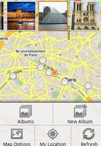
For your viewing pleasure: a new and improved way to explore online photos
When you’re curious about a new place - be it a restaurant that you haven’t yet tried or a popular tourist attraction you’re considering visiting on an upcoming trip - you may find it useful to see what that place looks like in advance. For this reason, Place pages make it possible to visually explore various locations by aggregating and displaying photos from around the web.
Today, we’re offering you a better, more streamlined way to view these photos. With this new feature, you can easily flip through a whole collection of photos and find the sites on the web that have relevant pictures of a given place. Photos that have been uploaded by our Panoramio or Google Places users will appear in high-resolution as an overlay when users click on them. For photos from other sources, you can easily click on a specific photo to see more and visit the site it comes from.


This simple and intuitive online album experience makes it easier to explore all the wonderful photographs of places all over the world. For example, the above photos on the Place page for Coit Tower in San Francisco really help bring the place to life since they’re shot from multiple angles and different times of day, and provide context about this landmark’s location in San Francisco.
If you’re interested in uploading your photos of places and making them more discoverable online, check out Panoramio, a great way to share geo-tagged photos on the Web.
Wednesday, September 15, 2010
The Marijuna Futures Market Mapped
The Price of Weed

Some enterprising supporters of the free market have developed this Google Map to track the retail price index of marijuana. In order to gauge the true street value of this globally traded product the Price of Weed has decided to crowdsource the cost of marijuana and post the results on a handy Google Map.
Currently the map only shows marijuana prices in the USA and Canada. Other countries will be added to the map once the data begins to flow in. If you click on a map marker you can view the average prices for weed in that location. You can also view the latest submission below the map.
Warning: Please remember the value of your investment in this market could go up in smoke.
Also See
Potlocator - medical marijuana dispensaries
Medical Marijuana Shopping - more medical marijuana dispensaries
Hat-tip: Street View Funny
5 Google Map Apps You Can't Live Without
I've only had an Android phone for a couple of weeks now and I've already discovered a few Google Maps based applications that I now can't imagine how I lived without.
Google Navigation, the Android phone's GPS navigation system has already proved invaluable to me on more than one occasion. I'm now looking forward to trying out the new Google Maps Navigation Walking.
I haven't had time yet to explore all the great Google Maps based applications available in the Android Market but here are five free applications that I have already installed and love:
My Tracks
 My Tracks allows you to record GPS tracks and view live statistics,such as time, speed, distance, and elevation, whilst hiking, biking or running. The application includes the option to export your tracks to Google Spreadsheets and visualise them on Google My Maps.
My Tracks also allows you to view the elevation profile of a track by time or distance, create waypoints on your track and spilt tracks into subtracks.
http://market.android.com/search?q=com.google.android.maps.mytracks
(use your Android phone to open these links - the links won't work from a desktop)
Google Sky Map
 The Google Sky Map is a brilliant window into the night sky and an essential tool for astronomers. The map uses the Android phone's built-in compass, GPS, and clock to display an annotated Sky Map of the area it is facing.
The application includes an horizon layer, planets layer, Messier Objects layer and a constellations layer. The application also includes a great gallery of Hubble photographs. If you click on a picture in the gallery the Sky Map will even point you towards the location of the subject in the night sky.
http://market.android.com/search?q=com.google.android.stardroid
Been There
 Been There is a Google Maps based browser for your photographs. The application allows you to view the photographs you have taken with your phone on a Google Map.
The photographs are displayed at the location where they were shot. This is a great way to browse photo albums on your phone. Not only does it allow you to view your pictures in their geographical context it is a handy way to find pictures, as you can normally remember where you were when you took a particular photograph.
http://market.android.com/search?q=com.picmap.ui
WHERE
 WHERE for Android is a local search and recommendation service. The application lets you search for local restaurants, bars and cafes and read real-time user reviews. The application comes with a host of other features, such as local events, gas prices, movies, weather, news, traffic information, special offers and coupons.
Once you have found a destination with the WHERE application you can get text or mapped directions. WHERE also includes a check-in feature called Placebook that helps you keep track of your daily travels and reviews.
RunKeeper
 RunKeeper uses the Android phone's GPS to track your runs. The application can track your distance, time, pace / speed and how many calories you burn. The applciation can also show you your track using Google Maps
RunKeeper Pro for Android has also just been released. This paid application has all of the same core functionality as RunKeeper Free, plus audio cues and no advertising.
http://market.android.com/search?q=com.fitnesskeeper.runkeepe
If you are interested in developing your own Google Maps based application for Android InformIT has a great tutorial: Mobile Mapping on Android and iPhone Using the Google Maps JavaScript API.
________________
Get your building modeled by PopArchitexture
We've discussed a variety of companies that can help you get your home or business modeled in Google Earth. I'm always happy to show off new companies, as increased competition is always good for us consumers.
The latest is a company called PopArchitexture. They got their start in Google's "Build Your Campus" competition back in 2006.
PopArchitexture offers three different pricing levels:
• 'Pure and Simple' tier: For $95, receive a 3D digital model viewable in Google Earth or embeddable on any website.
• 'Detailed' tier: For $295 and up, receive a detailed 3D digital model for GE or embeddable.
• 'Sophisticated' tier: For $595 and up, receive a hand built 3D paper model as well as a detailed 3D digital model.
In addition, you can get a 10% discount on any order that uses the voucher code 'GEARTHBLOG'.
The paper models are a unique option, and they appear to be quite cool. Here is an example of one they recently built for a client:
Of course, they're not the only option out there. We've covered a variety of different companies in the past, and here is a brief rundown:
Concept 3D: They offer custom 3D models in various formats including high quality photorealistic renders to Google Earth. They also offer web development services and interactive campus mapping service in Earth/Maps using 3D, 360 degree photography and video, which can leverage their Campus Bird interactive map site and CMS. Prices vary based on scope of project.
CyberCity 3D: For residential 3D they offer two options: "Premium" ($100-$150), usually done with terrestrial photo-textures provided by client and "Deluxe" ($200-$300), which includes more detail with added geometry.
Estate 3D: As we covered a few months ago, for $99 they'll do a single building that's composed of 50 faces or less.
Google Map of the Week
Commute Map

This Google Maps lets you discover who commutes where from any given zip code. The map uses data from the Census Transportation Planning Package and calculates travel times using the Google Maps API.
To use the map you first need to enter a zip code and choose whether you want to view commutes from this area or commutes to the area. The map will then displays the commuting results using blue lines and red map markers. The blue lines indicate where people commute to and from. The size of the red dots reflect the numbers of people commuting in that location.
As well as the map view Commute Map presents the results of your search via an interactive chart.
Google Map of London's Expensive Homes
Dwellings by Council Tax Map - Bands F,G,H

CASA's Map Tube has been used to visualise the number of houses in different council tax bands in London. The council tax is the name for local authority taxation in the UK.
The level of tax that citizens pay is based on the value of their homes. Band A homes are the cheapest properties and therefore pay the least in local taxation, Band H homes are the most expensive properties and the owners in Band H are required to pay more in council tax.
The Council Tax Maps overlay the number of properties in different tax bands over a map of London. The resulting choropleth maps show which areas of London have the most expensive and the cheapest houses.
One of the great features of Map Tube is that you can add different data sets to the map. This means that you can compare cost of housing in different areas in London to other data sets such as crime, drug use and health.
Check out the Map Tube search option to browse the available overlays.
Tuesday, September 14, 2010
What you say is what you search
Many of you have searched the web by speaking since the launch of voice search in 2008. In fact, one in every four searches from an Android phone in the US is by voice. In certain situations, voice search just works much better than typing. It’s a lot faster than typing on a small phone screen. You can search things even when you don’t know the correct spelling. It’s more fun as you can share what you’re doing with your friends. And it’s safer when you’re walking around. Once you start using voice search, you start discovering all sorts of new ways to use it.
We’ve thought of a few interesting uses for voice search and made some short videos out of them. Check them out on our new YouTube channel. But we know you can do better. What are some of your most frequent or unusual voice search queries? Leave us a comment below or on our YouTube channel.

We’ve thought of a few interesting uses for voice search and made some short videos out of them. Check them out on our new YouTube channel. But we know you can do better. What are some of your most frequent or unusual voice search queries? Leave us a comment below or on our YouTube channel.

Subscribe to:
Posts (Atom)