Sunday, December 19, 2010

Create a Google Map in 60 Seconds

TIXIK.com

If you need to create a simple Google Map then TIXIK.com can help. Using this map creator you can create an embeddable map for your website in a matter of seconds.

To create a map you just need to enter a location. A Google Map showing the location is then displayed with the code to embed the map on a website. If the location needs adjusting you can drag the map marker to the correct position.

TIXIK.com also allows you to adjust the height and width of your map, set the map type, the zoom level and adjust the map border.

The Lunar Eclipse Simulator

HeyWhatsThat: Eclipses

Early in the morning of December the 21st, on the winter solstice, there will be a total lunar eclipse. If you live in North America you should have great views of the eclipse. If you live in Western Europe you should be able to see the beginning of the eclipse.

HeyWhatsThat: Eclipses uses the Google Earth plug-in to simulate solar and lunar eclipses. Using Eclipses you can watch a simulation of the lunar eclipse from your location. Use the timeline beneath the Google Earth plug-in to view the eclipse at different times during the night.

If you live in the southern hemisphere you can enjoy the summer solstice. However you can also tune into NASA's live video feed of the eclipse.

usa maps


Map of the USA that is compatible with the Tag™ reading system. Loaded with facts about individual states and regions. For ages 4 - 7.


offiial site

Saturday, December 18, 2010

Imagery Update - Week of December 12th

‘Tis the season of giving! For those of you who’d like nothing more than to receive the gift of new places to explore on Google Earth and Maps, you’re in luck. Our imagery team’s latest update includes many places that relate metaphorically to the holiday season.

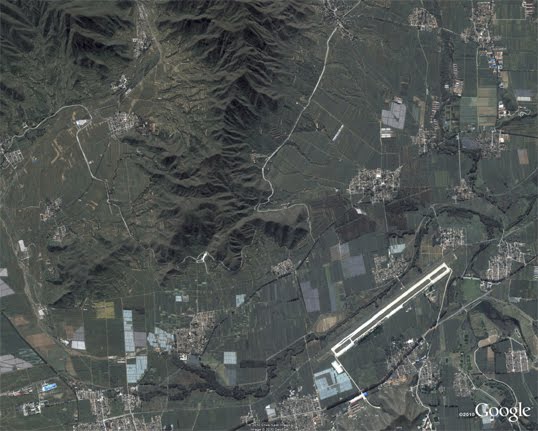
For example, it’s often at the end of the year that we remark “Out with the old, and in with the new.” That concept can also be applied to the below image that captures two military installations located North West of Beijing. You can see the fascinating juxtaposition of the modern Yongning Air Force base (bottom right) and an adjacent section of the ancient Great Wall of China (upper left quadrant) that outlines parts of the Shibapan Ling mountain range. And yes, you really can see the wall from space!

Near Beijing, China

Wouldn’t gold make a great stocking stuffer? Take a look at the below image of Jin Xixin Lake, the dammed section of the Minjiang River also known as the Gold Lake, located south of Mount Wuyi, China. In this image, you can see lots of prime locations that might make great prospecting camps. Get out your pans!

Gold (but no frankincense) near Mount Wuyi, China

Finally, although this time of year is often associated with the Christian-based holidays, when thinking about China, thoughts naturally turn to Buddhism. Just the other day on the Google campus in Mountain View, a group of Tibetan monks visited to build a Sand Mandala and lead a meditation group. In this spirit, I’ve included the below image of the first Buddhist monastery built in Tibet, the Samye Monastery.

A site of enlightenment in Tibet

The examples above only hint at the type and breadth of features that can be seen and discovered in our latest batch of published imagery. Happy exploring and happy holidays!

High resolution aerial updates:
USA: Birmingham AL, Little Rock AK, Peoria IL, Tuscaloosa AL, Worcester MA, Jerome ID, Stevenson WA, Knoxville TN, Morganton NC, and Statesville NC
Canada: Powell River, and Sunshine Coast, BC., Canmore, and Cold Lake
Netherlands: Hilversum
South Africa: Northern, Eastern, and Western Cape, and Limpopo
Sweden: Gävleborgs Län, Jönköpings Län, Uppsala Län, Västerbottens Län, and Västra Götalands Län

Countries receiving high resolution satellite updates:
Albania, Algeria, Angola, Argentina, Armenia, Australia, Austria, Azerbaijan, Bahrain, Bangladesh, Belgium, Bhutan, Bolivia, Bosnia and Herzegovina, Botswana, Brazil, British Virgin Islands, Brunei Darussalam, Bulgaria, Burkina Faso, Cambodia, Cameroon, Canada, Chad, Chile, China, Colombia, Costa Rica, Croatia, Cuba, Democratic People's Republic of Korea, Democratic Republic of the Congo, Denmark, Dominican Republic, Ecuador, El Salvador, Estonia, Ethiopia, Finland, France, Georgia, Germany, Greece, Guatemala, Haiti, Honduras, Hungary, India, Indonesia, Iran, Ireland, Israel, Italy, Japan, Jordan, Kazakhstan, Kenya, Kuwait, Kyrgyzstan, Laos, Latvia, Lesotho, Liberia, Libya, Lithuania, Luxembourg, Madagascar, Malawi, Malaysia, Mali, Mauritania, Mexico, Mongolia, Montenegro, Morocco, Mozambique, Myanmar, Namibia, Nepal, Netherlands, New Caledonia, New Zealand, Nigeria, Norway, Oman, Pakistan, Panama, Papua New Guinea, Paraguay, Peru, Philippines, Poland, Portugal, Puerto Rico, Republic of Korea, Romania, Russia, Samoa, Saudi Arabia, Senegal, Serbia, Slovakia, Slovenia, Solomon Islands, South Africa, Spain, Sri Lanka, Sudan, Sweden, Switzerland, Syria, Taiwan, Tajikistan, Tanzania, Thailand, Turkey, Turkmenistan, Uganda, Ukraine, United Arab Emirates, United Kingdom, United States, Uruguay, Uzbekistan, Venezuela, Vietnam, Virgin Islands, West Bank, Yemen, Zambia, Zimbabwe

These updates are currently only available in Google Earth, but they'll also be in Google Maps soon. To get a complete picture of where we updated imagery, download this KML for viewing in Google Earth.

The Antique Map for your iPhone

The Cartographer

The Cartographer is an iPhone app that combines an antique map style with custom Google My Maps viewing and editing.

The unique selling point of The Cartographer has to be its unique antique map design but it also has a number of other useful features. The Cartographer syncs well with Google My Maps. You can create Google My Maps from your desktop and the resulting maps can be effortlessly accessed and edited on the iPhone.

Users can also access The Cartographer offline and so avoid data and roaming charges.

________________

Labels:

Under the hood of Google Maps 5.0 for Android

Yesterday we introduced Google Maps 5.0 for Android with two significant new features: 3D interaction and offline reliability. In order to create these features, we rebuilt Maps using vector graphics to dynamically draw the map as you use it. Building a vector graphics engine capable of achieving the visual quality and performance level you expect from Google Maps was a major technical challenge and enables all sorts of future possibilities. So we wanted to give you a closer look under the hood at the technology driving the next generation of mobile maps.

Vector graphics
Before diving into how Maps uses vector graphics, it may be helpful to understand how maps were created before. Previously, Google Maps downloaded the map as sets of individual 256x256 pixel “image tiles.” Each pre-rendered image tile was downloaded with its own section of map imagery, roads, labels and other features baked right in. Google Maps would download each tile as you needed it and then stitch sets together to form the map you see. It takes more than 360 billion tiles to cover the whole world at 20 zoom levels!

Now, we use vector graphics to dynamically draw the map. Maps will download “vector tiles” that describe the underlying geometry of the map. You can think of them as the blueprints needed to draw a map, instead of static map images. Because you only need to download the blueprints, the amount of data needed to draw maps from vector tiles is drastically less than when downloading pre-rendered image tiles. Google Maps isn’t the first mobile app to use vector graphics—in fact, Google Earth and our Navigation (Beta) feature do already. But a combination of modern device hardware and innovative engineering allow us to stream vector tiles efficiently and render them smoothly, while maintaining the speed and readability we require in Google Maps. Just try it out and see for yourself!

See the difference between image tiles (left) and vector tiles (right) tilted to show 3D buildings.

One map, many perspectives
Using vector tiles instead of image tiles gives Maps the flexibility to re-draw the same map from different perspectives using the same set of data. Zooming is one example of this at work. If you magnify an map image tile by 2x, lines such as roads and text would get twice as wide and appear blurry. As a result, we had to constrain Maps to 20 fixed “zoom levels,” each one twice as close as the last. Every time you zoomed in further, you’d need to download a completely new set of image tiles. It took time to load new data over a mobile data connection, and would fail when you lost your connection in a subway or large building.

Compared to image tiles (left), vector tiles (right) keep lines and labels crisp as you zoom.

With vector graphics, you no longer need to “round” to the nearest zoom level and then download all the tiles for that level. One vector tile has the underlying vector data (or blueprints) to draw the map at many different levels of scale. So when you zoom, the map stops when your fingers stop, and roads and labels always stay crisp. This same technique powers the new 3D map interactions: tilt, rotate and compass mode. Just like with zooming, Maps uses the same vector data to draw the map from any angle or direction as you tilt or rotate.

We can also display entirely new levels of detail that weren’t possible with flat image tiles. For example, in the 100+ cities where we have 3D building data, each building is drawn in 3D using a polygonal building footprint and heights for different parts of the building. And with tilt and rotate, you can see them from a variety of different angles.

Reading the map
Just like other map features, labels are dynamically drawn so they continue to face you and stay legible if you rotate the rest of the map or use compass mode. Maps also “chooses” the best labels to show you based on several factors. You’ll notice labels fade in and out as you interact with the map so that the most useful ones appear and the map never gets too cluttered.

See the difference between rotating maps with static labels (left) and dynamic labels (right).

Vector graphics also allow us to draw additional data on the map more clearly. For example, traffic or transit lines no longer block the labels beneath them. We can also draw the same map in different styles—like “satellite view” where the roads are translucent over aerial imagery, or Navigation’s “night mode” where a darker palette helps your eyes adjust quickly in the lower light.

Previously, map features like labels and traffic could conflict (left) instead of blend seamlessly (right).

Offline reliability
Vector graphics also enable another significant new feature: the ability to continue viewing maps even when you have poor—or no—network connections. Because each vector tile works across multiple zoom levels, it requires more than 100 times less data to view maps across all zoom levels than before, allowing Maps to cache much larger areas of the map on your device.

With this first version, Maps proactively caches map data for the places you use Maps the most—where you’re actively using it as well as places for which you search or get directions. Then when you’re plugged in and connected over WiFi, caching happens automatically. Near your frequent places, you’ll get detailed vector tiles for city-sized regions so you can see every road labeled. Further away, you’ll have less detail but will typically have towns and highways labeled for miles. We’re continuing to work on these algorithms, so you’ll see improvements over time.

Offline rerouting
With Google Maps Navigation (Beta), you’ll also see the benefits of additional caching with offline rerouting. This feature is only possible because Navigation caches not only map data but also data like turn restrictions for the areas surrounding your route. You’ll still need to be connected when you first start a trip to download and cache your route. But this way, even if you take a wrong turn after losing your connection, Navigation can use the cached data to get you back on your way. We will be rolling this feature out gradually over the next few weeks.

This is just the start, and we’re really excited about all the possible ways to use vector graphics technology for the next generation of Google Maps. So please stay tuned!

Friday, December 17, 2010

Friday Fun with Google Maps

" layout="standard" show_faces="true" width="450" action="like" colorscheme="light">Google Maps FAIL

I find this very hard to believe - apparently Google Maps occasionally makes mistakes. Google Maps FAIL is dedicated to exposing the sometimes hilarious errors in Google Maps.

Fail Maps is another nice blog highlighting the mistakes made in maps.

Google Demo Slam
These two videos, featured on Google Demo Slam, caught my eye this week.

Hat-tip: @geoparadigm


Map Ties

I've had to wear a tie a couple of times in my life. It's not an experience I want to repeat. But if you do force me then I want to wear one of these natty numbers.

________________

Labels:


Great British Google Maps Round-Up

Great British Life

Great British Life is a website that celebrates everything that is great about Great Britain. This celebration includes a Google Map that allow readers to browse restaurant reviews, upcoming events and reader's photographs by location.

It is possible to filter the map by 'articles', 'events', 'photos' and 'blogs'. If you click on a map marker you can read a brief review and view ratings. Each window also includes a link to read the full article.

LiveMap Devon

Prolific Google Maps developer Colin Johnson has produced a number of UK based Google Maps under the LiveMaps label.

This Google Map details events in the county of Devon, featuring Town Shows, Carnivals, Farmers Markets etc. The map displays events for the next three months. The map also links to a Devon Live Entertainment page which features the leading theatres and venues in the region, a Devon Attractions site detailing a wide variety of things to do and places to visit and a Devon Holiday Accommodation page.

LiveMap English Football Ground Guide
This Google Map is a guide to the soccer clubs in the top 16 divisions of English football.

LiveMap RoadworksLiveMap Lincoln Essentials
This Google Map is a directory with a difference. Detailing a range of useful locations such as car parks, cash machines, recycling banks, post offices in the city of Lincoln

LiveMap Wildlife Parks
LiveMap Wildlife Parks plots the location of over 130 zoos, safari parks, butterfly farms and other wildlife attractions throughout the UK.

LiveMap Theatres & Venues
Details hundreds of theatres and live entertainment venues throughout the UK.

Citizens Report UK
Citizens Report UK, a website dedicated to helping citizens improve their personal safety, uses Google Maps to help report on many safety and crime issues in the UK. A couple of weeks ago Google Maps Mania featured the Citizens Report UK map of British Road Casualties 2008 & 2009.

Interactive Map of Recorded Offence

This Google Map uses Fusion Tables plots Recorded Offence Volumes in the Local Authorities of England and Wales - from 2003 to 2010.

The map makes great use of the Fusion Tables queries function. It is possible to refine the results shown on the map by offence, date and region.

________________

Labels:

Paris in 3D

The Eiffel Tower is one of the most popular sights in Google Earth, and it's had a high-quality 3D model for a few years now. However, the rest of the city has been rather flat -- until now.

Google has rolled out extensive 3D building coverage for the city and it looks great! (NOTE from Frank: There are some areas - especially around the Eiffel Tower, where the building models look half-finished. Many of the sides are missing photo-realistic textures. But, hopefully this will inspire people to use Building Maker to finish the models.]

paris.jpg

Check out some of the cool sites like the Eiffel Tower, the Notre Dame Cathedral or the the Arc de Triomphe.

To simply explore the city for yourself, fly there using this KML file.

Google Maps for Android adds 3D, offline reliability and re-routing

Those who checked their Android device to see if their Android Market apps need an update were pleasantly surprised on Thursday. Google has released Google Maps 5.0 for Android, including 3D support (sans glasses) and greater offline reliability.

Here's how the 3D portion is explained (although, only some 100+ cities currently have the 3D imagery set up).
Until now, Google Maps has always downloaded the map as a set of small, square images that we stitch together to form the map you see. (You’ve probably seen those gray squares getting filled in, block-by-block, as the images load over the network.) Starting today, we’ll use vector graphics to dynamically draw the map on your device as you use it, allowing you to interact with it in new ways:
  • Tilting: Drag down with two fingers to tilt the map. Tilt while zoomed in on one of the 100+ cities around the world with 3D buildings to see a skyline spring to life.
  • Rotating: Twist with two fingers to rotate the map. After tilting to see 3D buildings, rotate around them to gain a new perspective from any direction.
  • Smooth zooming: Slide two fingers together or apart, and see the map and labels continuously scale to any zoom level, stopping when your fingers stop.
  • Compass mode: Center the map on your location, and then tap the compass button in the top right corner. The map will flip into 3D mode and start rotating to match your perspective, while still keeping all the labels upright and readable.
Vector graphics are also much lighter weight than the traditional stitched-together images used previously, which leads into the other change: better caching to allow better offline functionality.

Google will do this by caching the areas you visit the most. They'll do this at night when your device is connected to wi-fi and charging.

Finally, they are also adding offline re-routing, though this will roll out gradually over the next few weeks. You'll still need a connection to start a route, but if you lose it after that, you yourself won't get lost. Google says:
You’ll still need a connection to start a route, but if you miss a turn along the way, we’ll quickly get you back on track, even if you don’t have an Internet connection. We’ll be rolling this feature out gradually over the next few weeks.
While Android 1.6 devices can get Google Maps 5.0, it won't have the 3D or offline features; those require Android 2.0+. At least those devices still stuck on Android 2.1 can get the features.

Also, some devices will not support all the features. These limitations are detailedhere. You can watch a video on Google Maps 5.0 below.