Tuesday, July 6, 2010

Education Tidbits


"Fairfax County Public Schools and Google Inc. are pairing up to create an educational initiative in advanced Google Earth applications."

Google will train Fairfax Virginia area educators to use Google Earth products. Teachers, in turn will then produce at least 24 curriculum packets (meeting state and federal ed guidelines) which will be distributed worldwide. Teachers will receive stipends as part of the $35,000 donation from Google.


Terry Brase, associate professor of ag geospatial technology, and his team at Kirkwood Community College in Cedar Rapids, IA, have built a program for students with designs on a career in agriculture technology. There's an interview with Brase about the two year program which features GIS, GPS and precision-focused career training.


Princeton University historian John Haldon, a leading authority on medieval Byzantine history is leading a project to make sense of a rural town via the Euchaita/Avkat Project in Turkey, near the current-day village of Beyozu.


One of the project's unusual aspects is that it has integrated GIS (geographical information system) technology and mapping right from the beginning of the research.
"We can basically reconstruct the medieval landscape, land-use patterns, communications network, hydrology" and other information into computer models, he said.


Bowdoin College (Brunswick, ME) Environmental Studies students have been contributors to the Sagadahoc Regional Rural Resources Initiative (SRRRI), which is the outgrowth of region-wide interest in protecting the area's "rural resources" for four years. Students have done GIS needs assessments, mapping wildlife corridors, and provided maps to local communities. That made the program part of the project that was awarded the Association of Maine Planners: "Plan of the Year." 

Crowdsourcing Competitive Intelligence by iPhone


This makes complete and utter sense to me. Instead of having professional (aka high priced) competitive intelligence practitioners do the (completely legal) field work required to track prices or the number of cars in the parking lot, why not outsource it to people with iPhones and pay them for each small task? That's what Field Agent does. Go snap a picture of a BBQ at Target via your iPhone and get a few bucks via PayPal. Or, do a survey while sitting on the bus and get a few more. The money goes to your account within 48 hours. 

WGRZ

Monmonier on e-Maps Restricting our Freedom


He writes in New Scientist.
In 2010, however, restrictive cartography is on the verge of more invasive applications as electronic technology replaces graphic lines requiring conscious interpretation with invisible fences, erected by proactive, self-enforcing geographical restrictions.

GPS Tidbits


Singapore has put out a tender to us GNSS to solve its congestion problems on the roads. The current system uses "tolls" with "smart cards" but adding in new "toll booths" is simply costly and causes more congestion in other areas as drivers try to finder cheaper alternatives. The hope is that satellite managed systems will make the payment simpler and keep traffic moving.


911 ETA is new software for smartphones and in-car GPS systems designed to "pre-alert" drivers of on-coming emergency vehicles. It will be tested by Denver's West Metro's Fire Department later this year. Smartphones will "buzz" and in-car GPS will speak a warning when the vehicle is within 900 feet - but that can be adjusted as the jurisdiction prefers. The system can be made to turn down the radio and open windows.


Intel is developing a "black box" for cars that could do everything from video where the car has gone (to share with insurance companies after an accident), keep tabs on nearby cars (to help the driver from getting to close), take over the driving (when a car goes the wrong way down a one way street) and even report potholes (to local authorities).

CyberCity 3D unveils the Sanborn Emergency Response Map


CyberCity 3D has teamed up with The Sanborn Map Company to create an "engaging map can be customized for a variety of uses for entities including Emergency Medical Services, Police Departments, Fire Departments, Utilities, and Public Safety. Available data includes specific building types and locations; emergency exits; fire hydrant/fire house sites; utilities; and parking." An example of the map is seen below, and you can try it for yourself here.
cybercity-sanborn.jpg
This product will officially launch at the 2010 ESRI International User Conference in a couple of weeks.
More merged products from the two companies are expected in the future, which makes perfect sense given their very complimentary offerings. I think we'll see some great stuff from them in the future.
The full text of their press release is below:
El Segundo, CA - CyberCity 3D, Inc., a state-of-the-art 3D geospatial modeling company based in El Segundo, CA and international geospatial solutions provider The Sanborn Map Company, headquartered in Colorado Springs, CO, today announced they will launch the first of a series of products resulting from their recent partnership at the annual ESRI International User Conference in San Diego, CA July 12th through the 16th.

The Sanborn Emergency Response Maps website combines Sanborn's detailed CitySets and CyberCity 3D's data integration to provide critical building and surrounding area information through the power of the Google Earth™ API plug-in. The site (www.cybercity3d.com/sanbornermaps) offers maps in 3D on Google Earth™ through its API plug-in, in 2D on Google maps™, in Google Street View™, and via satellite imagery.

This engaging map can be customized for a variety of uses for entities including Emergency Medical Services, Police Departments, Fire Departments, Utilities, and Public Safety. Available data includes specific building types and locations; emergency exits; fire hydrant/fire house sites; utilities; and parking.

"We look forward to working with Sanborn to deliver new and engaging public services web mapping sites. The synergies between the two companies are quite complimentary. Web mapping is undergoing great change and the combination of Sanborn's vast experience and strong relationships combined with CyberCity's cutting-edge technologies is a perfect fit," CyberCity 3D CEO Kevin DeVito stated.

"Sanborn and CyberCity 3D combined now have the largest online catalog of 3D structures. Coupled with the advanced web application services, we are even more capable to meet and exceed our customers' requirements today and in the future," said Robert Lega, Sanborn Products Manager.

The CyberCity 3D / Sanborn alliance enables the companies to provide groundbreaking GeoWeb solutions like the Sanborn Emergency Response Maps to a variety of government agencies and geographic information system (GIS) services as well as data products.

The CyberCity 3D/Sanborn collaboration integrates the two companies' 3D libraries to bring clients more 3D choices and high quality, cutting-edge web solutions-- including those built around the Google Earth™ API platform.

In their continuing partnership, the companies plan to create more merged products involving web publishing and planning.

About CyberCity 3D, Inc.:
CyberCity 3D (www.cybercity3d.com) specializes in emerging GeoWeb solutions for government agencies, the environment, geographic information systems (GIS), and travel destinations, as well as commercial and residential real estate. The Company also develops 3D, web-based, energy efficiency applications in addition to green house gas (GHG) information-gathering and computing tools designed to assist municipalities, utilities, and environmental agencies in their implementation of environmentally sustainable programs. CyberCity 3D is one of the first to offer realistic, three-dimensional, building and city models through the Google Earth™ API plug-in.

About Sanborn Map Company, Inc.:
Sanborn (www.sanborn.com) has been delivering quality geospatial solutions to clients worldwide since 1866. Sanborn provides high value solutions for mapping and geographic data, imagery and spatial analysis, custom applications, system integration, data management, and outsourcing as well as advanced web-based information systems, 3D modeling and visualization systems for customers worldwide.

Tales of the South Pacific — Suwarrow Atoll


Sometimes the actions of a remarkable person on a remote island forever mark that place, turning it into an destination for future generations of adventurous fans. Some well-known examples are Paul Gauguin with Hiva Oa, Father Damien with Molokai, Ernest Shackleton with Elephant Island and Robert Louis Stevenson with Upolu.
220px-TomNeale.jpg
Then there is the case of 
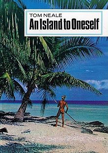
Tom Neale, who is less famous, though no less remarkable. In 1952, at the age of 50, he decided to cast off from society and survive by himself on an uninhabited and remote atoll in the South Pacific. He then wrote a book about his adventures — An Island to Oneself, published in 1966 — which ever since has enjoyed cult status among adventurers and lovers of the South Pacific. He ended up living on his island for a total of 16 years in three stints, up until shortly before his death in 1977.

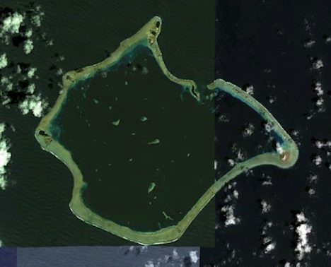
The "island" Neale had to himself isSuwarrow atoll, atop a lone and remote seamount in the northern Cook Islands, out of the way of shipping routes. I was unaware of both Neale and Suwarrow until yesterday, when I learned that two friends are planning to drop anchor there on their sail across the Pacific. I wondered what attracted them to Suwarrow, so I googled the place. Tom Neale's adventures immediately stood out, and brought the place to life.
suwarrow-sat.jpg
Soon, I discovered that long extracts of Neale's book are available online (part 1part 2part 3). Be careful, because it makes for addictive reading: I thought I'd skim it in 15 minutes, but several hours later I was still at it, rapt, and managed to finish the book today.
Neale goes into meticulous detail about what surviving on a deserted island requires, along with the mishaps that befell him, the lucky escapes, and tales of the infrequent (and often dumbfounded) visitors. But the book's appeal transcends its narrow focus, because his life plays out a fantasy many of us have had from the safety of our cubicle offices — what would it be like to be Robinson Crusoe, for real?
No wonder my friends are headed that way, to take in, just for a day or two, Neale's world. Rhian and Andy are sailing across the Pacific from Chile (and blogging the trip, including their harrowing account of destruction and rescue when the Chile quake tsunami hit the Juan Fernandez islands). Rhian is an Antarctic research scientist while Andy is an ex-military adventurer-climber, so their attraction to Neale's tale of extreme self-sufficiency makes perfect sense.
Neale's book describes his atoll very precisely — the lengths and shapes of the various islets, the location of the pier he tries to repair, his cabin, the beaches he combs for flotsam, the trees he uses for food or tools... All of it ripe for enhancement with Google Earth.
Sure enough, Google Earth delivers very high resolution imagery from several different dates: February 5 and January 13, 2009, as well as from April 5, 2005 and November 17, 2004. Each set has different strengths — for example, the 2004 imagery has the most glorious turquoise views of the reefs. On all images you can see the pier, his cabin, the beaches, even the specific trees he mentions, and you can certainly count the crowns of the palm trees.
suwarrow.jpg
(To scrub between these different images, zoom in on Suwarrow, turn on the historical imagery slider and drag the marker to the different dates.)
Here is a KMZ file for Google Earth pinpointing the location of Suwarrow, and adding many of the places Neale mentions. Place names were added after cross-checking with this high resolution map of Suwarrow.
Strangely, around the atoll there is a large (15km) discrepancy between Google's place name database and the satellite imagery. (The high resolution map linked to above corresponds to the satellite imagery). Geonames.org also shows a (smaller) discrepancy, so there is definitely a need to reconcile these diverging datasets.

These days, all of Suwarrow Atoll is a national park and one of the Pacific's most important bird breeding areas. A caretaker lives on the island during the off-cyclone season, with perhaps 50 yachts per year visiting. (You can see several boats at anchor in the 2005 imagery.) A room in Neale's cabin has been preserved just as he left it.

It's people and places like Neale on Suwarrow that make the world such an interesting place. It's just up to us to get out and go find them.

Google Earth tip: Give precedence to imagery along coastlines


Prolific neogeographer Barry Hunter at nearby.org.uk has a gripe with Google Earth's visualization of ocean bathymetry, because it takes precedence over aerial and satellite imagery, which often would show features in shallow water. He's even started a petition to make the 3D rendering of oceans in Google Earth optional.
A worthy cause, no doubt, but in the meantime there is a simple hack that gives back most of what Barry wants: Simply turn on the historical timeline in Google Earth, then drag the handle just a fraction into the past — bingo, the unseemly seam where imagery meets bathymetry is gone, with the most recent image tiles regaining the upper hand. Try it on Suwarrow Island from the previous post.

Wage Negotiations with Google Maps


During the next year a new period of negotiations for a collective wage agreement will take place in Sweden. This Google Map from Almega, a Swedish employers' organisation is designed to raise the debate about wages and how people think work should be valued.

Anybody can share their opinions and experiences of wage negotiations with the website and they will appear on the map. Users can also take a simple test which will show which of four criteria – experience, development, engagement or achievement – is valued the most. Users can also share stories about the wage negotiation process.

Each test result and story is added as a marker on the map depending on where the user lives. There is also the possibility of commenting on other user's test results or stories.

The map is the creation of StoryLabs and Sthlm Connection. Sthlm Connection are writing a series of posts on how they created the map. There are three tutorials, the first of which is Creative Google Maps I: Taking control of the location.

Follow Team HTC-Columbia on Google Maps


As a former professional cyclist, nothing beats the thrill of being in the peloton and racing towards the finish line. Although I’ve traded in my cycling career for life as a Googler, I’m still a fan and enjoy watching my former teammates and friends battle in races like the Tour de France, which started on Saturday. While the cyclists were preparing to tackle the pave of Arrenberg and the Cols in the Alps, I got to thinking about ways that we can bring that experience to the hundreds of millions of fans who will be following the Tour de France over the next few weeks. Google is home to many other cycling enthusiasts, so we got together to work on ways to build a My Tracks-based gadget that will allow all the other fans to follow the action like never before.

The My Tracks application for Android phones lets you record and share your own outdoor activities, and now Team HTC-Columbia will use a special version of the app with SRM to transmit their telemetry and location in real-time as they make their way through the 3,642 kilometers of the Tour de France. The nine riders (sadly, now eight, as Adam Hanson was injured on Sunday) on Team HTC-Columbia are carrying HTC Legend phones with ANT+ that use My Tracks to capture their location along with their power, heart rate, cadence and speed. On www.google.com/mytrackstour, you’ll see a Google Map showing the team members’ location on the course and a detailed telemetry report. You can observe how Michael Rogers’ heart rate spikes as he attacks the climbs in the Alps on Stage 9, see how many watts Mark Cavendish puts out in the sprint on the famous sprinters’ stage into Bordeaux, and see just how fast riders climb the famous Col du Tourmalet.


From the image above, you can see how Maxime Monfort took the lead during Stage 2 between Bruxelles and Spa yesterday. Right now, the riders are racing in Stage 3, which takes them across the border into France and you can follow all the latest action on our website or directly on your own iGoogle page.

The team also built a map gadget that is available for you to embed on your own website or blog. We’re also publishing an API that any web developer or broadcaster can use to build their own custom application or use to enhance the live television coverage. I'm excited about the potential for web developers and broadcasters to make use of the API and data in creative ways to help all the Tour de France followers (myself included!) get even closer to the action.

This project was the work of many Googlers in their 20% time, and as cycling fans ourselves, we’re happy to be able to share it with the world. We hope you enjoy this unique way of following Team HTC-Columbia over the next few weeks.

Sunday, July 4, 2010

Welcome to Plymouth with Google Maps


Google Maps is such a great tool for promoting towns and cities I'm surprised there aren't more sites like 3D Plymouth. 3D Plymouth is a Google Maps based guide to the picturesque town of Plymouth, Michigan.

Plymouth 3D uses the Google Earth browser plug-in to allow you to explore the town in glorious 3D. If you don't like the 3D option you can select Google Maps to view all the information with a normal map view.

And what a lot of information there is.

Plymouth 3D can show you the location of any store in the town. If you need a hair cut, select 'Barber' and you can view the location of all the town's barbers, or maybe you fancy an icecream, if so just select 'Candies & Ice Cream'. There is in fact over 40 categories of store to choose from.

If you have finished your shopping then Plymouth 3D can even help you find some entertainment. The 'Locate Events' section can show you the location of upcoming entertainment and sporting events in the town.

There are also options to view the weather, local traffic, road closures, schools, Street View and local property for sale. There are so many options with this map that I'm sure I've even missed a few.